

194 Kikuro Miyakoda
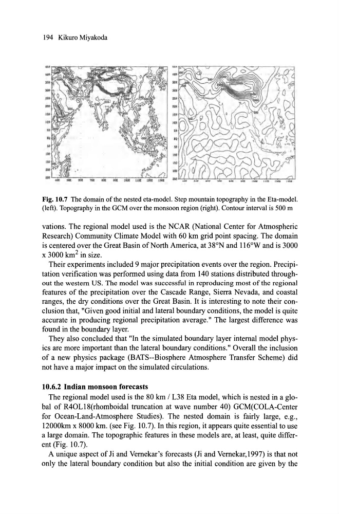
Fig. 10.7 The domain ofthe nested eta-model. Step mountain topography in the Eta-model.
(Ieft). Topography in the GCM over the monsoon region (right). Contour interval is 500 m
vations. The regional model used is the NCAR (National Center for Atmospheric
Research) Community Climate Model with 60 lan grid point spacing. The domain
is centered over the Great Basin ofNorth America, at 38°N and 116°W and is 3000
x 3000 1an 2 in size.
Their experiments included 9 major precipitation events over the region. Precipitation verification was performed using data from 140 stations distributed throughout the westem US. The model was successful in reproduc ing most of the regional
features of the precipitation over the Cascade Range, Sierra Nevada, and coastal
ranges, the dry conditions over the Great Basin. It is interesting to note their conc1usion that, "Given good initial and lateral boundary conditions, the model is quite
ac curate in produc ing regional precipitation average." The largest difference was
found in the boundary layer.
They also concluded that "In the simulated boundary layer internal model physics are more important than the lateral boundary conditions." Overall the inclusion
of a new physics package (BATS--Biosphere Atmosphere Transfer Scheme) did
not have a major impact on the simulated circulations.
10.6.2 Indian monsoon forecasts
The regional model used is the 80 lan / L38 Eta model, which is nested in a global of R40Ll8(rhomboidal truncation at wave number 40) GCM(COLA-Center
for Ocean-Land-Atmosphere Studies). The nested domain is fairly large, e.g.,
120001an x 8000 lan. (see Fig. 10.7). In this region, it appears quite essential to use
a large domain. The topographic features in these models are, at least, quite different (Fig. 10.7).
A unique aspect of Ji and Vernekar's forecasts (Ji and Vernekar, 1997) is that not
only the lateral boundary condition but also the initial condition are given by the
Fig. 10.7 The domain ofthe nested eta-model. Step mountain topography in the Eta-model.
(Ieft). Topography in the GCM over the monsoon region (right). Contour interval is 500 m
vations. The regional model used is the NCAR (National Center for Atmospheric
Research) Community Climate Model with 60 lan grid point spacing. The domain
is centered over the Great Basin ofNorth America, at 38°N and 116°W and is 3000
x 3000 1an 2 in size.
Their experiments included 9 major precipitation events over the region. Precipitation verification was performed using data from 140 stations distributed throughout the westem US. The model was successful in reproduc ing most of the regional
features of the precipitation over the Cascade Range, Sierra Nevada, and coastal
ranges, the dry conditions over the Great Basin. It is interesting to note their conc1usion that, "Given good initial and lateral boundary conditions, the model is quite
ac curate in produc ing regional precipitation average." The largest difference was
found in the boundary layer.
They also concluded that "In the simulated boundary layer internal model physics are more important than the lateral boundary conditions." Overall the inclusion
of a new physics package (BATS--Biosphere Atmosphere Transfer Scheme) did
not have a major impact on the simulated circulations.
10.6.2 Indian monsoon forecasts
The regional model used is the 80 lan / L38 Eta model, which is nested in a global of R40Ll8(rhomboidal truncation at wave number 40) GCM(COLA-Center
for Ocean-Land-Atmosphere Studies). The nested domain is fairly large, e.g.,
120001an x 8000 lan. (see Fig. 10.7). In this region, it appears quite essential to use
a large domain. The topographic features in these models are, at least, quite different (Fig. 10.7).
A unique aspect of Ji and Vernekar's forecasts (Ji and Vernekar, 1997) is that not
only the lateral boundary condition but also the initial condition are given by the