

Physical Characteristics of Coastal Hazards 25.2 Coastal Impacts 555
Part C | 25.2
In summary, existing development and future
anthropogenic activities may themselves aggravate
coastal flooding and erosion. Combined with other natural threats, including sea-level rise, it is prudent consider long-term and regional impacts during all phases
of coastal development, planning, and design.
25.2 Coastal Impacts
25.2.1 Winds
Winds associated with both tropical and extratropical
cyclones must be considered during coastal development. High winds, which vary temporally and spatially,
can damage residential and commercial infrastructure
and can lead to route closures during evacuation. From
a coastal engineering perspective, an understanding of
storm winds is also relevant as they are the primary
forcing mechanism for wave and surge generation.
Field observations via satellite, point measurement, and
real-time aircraft-based measurement transects have
been used recently to successfully reconstruct cyclone
wind fields [25.69, 70] and to provide real-time information on wind speeds. For cyclonic winds, the
momentum balance yields the following equation for
wind speed (U) in a moving reference frame relative to
the cyclone’s center
U D
1
a f
@p
@r
C
U
2
f O
r c
;
(25.1)
where a is air density, f is the Coriolis parameter, p
is the barometric pressure, r is the radial distance from
the cyclone’s center, and O
r c is the radius of curvature of
the isobars. The actual wind velocity relative to earth
(U a ) must include the storm’s translational, or forward,
velocity (V f ). A simple approximation of the actual
wind velocity is the vector sum: U a D U C V f . Thus,
the strongest winds in a cyclone are typically in the forward right (left) quadrant of the storm for storms in the
Northern (Southern) hemisphere.
Because they tend to be less well organized, wind
fields from extratropical cyclones are not as readily parameterized, and wind-field reconstructions for
individual storms are typically developed from observations [25.71]. On the other hand, because tropical
cyclones tend to be well organized, several vortex-based
models exist [25.72–75] that may be used to estimate
the cyclone’s wind field for use in coastal hazard analysis and engineering design. The class of models known
as planetary boundary layer (PBL) models generally
assume that the tropical cyclone’s barometric pressure
field (p) is described as follows,
@p
@r
D
B.p far p c /
r
 R max
r
à B
exp
"
 R max
r
à B
#
;
(25.2)
where r is the radial distance from the cyclone’s center,
B is Holland’s [25.72] pressure profile shape parameter, p far is the far-field barometric pressure, p c is the
cyclone’s central pressure, and R max is the radial distance from the cyclone’s center to the location of the
maximum wind speed. Equations (25.1) and (25.2) may
be solved numerically to develop the tropical cyclone’s
wind field. In the centermost portion of the tropical
cyclone, the second term in (25.1) approaches zero, allowing analytical estimation of the maximum relative
wind speed parameter, U max
U max D
s
B
a e
.p far p c / ;
(25.3)
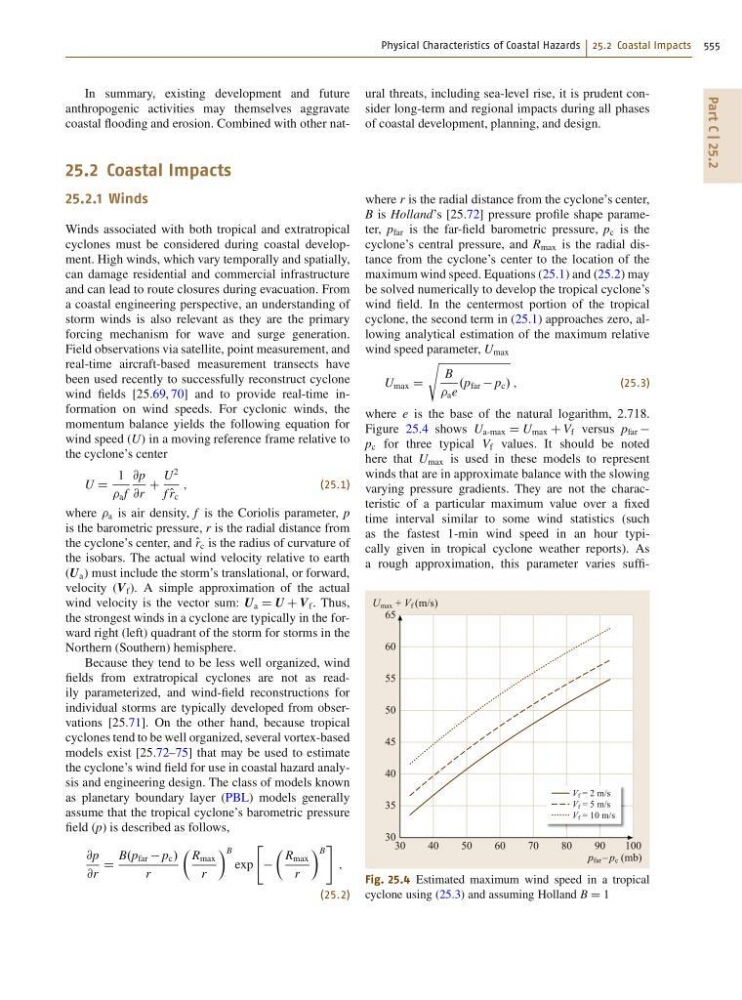
where e is the base of the natural logarithm, 2.718.
Figure 25.4 shows U a-max D U max C V f versus p far
p c for three typical V f values. It should be noted
here that U max is used in these models to represent
winds that are in approximate balance with the slowing
varying pressure gradients. They are not the characteristic of a particular maximum value over a fixed
time interval similar to some wind statistics (such
as the fastest 1-min wind speed in an hour typically given in tropical cyclone weather reports). As
a rough approximation, this parameter varies suffiV f = 2 m/s
V f = 5 m/s
V f = 10 m/s
30
40
50
60
70
80
90
100
U max + V f (m/s)
p far – p c (mb)
65
60
55
50
45
40
35
30
Fig. 25.4 Estimated maximum wind speed in a tropical
cyclone using (25.3) and assuming Holland B D 1