

Autonomous Underwater Vehicle Navigation 14.4 Conclusion 353
Part B | 14.4
14.3.3 Standard AUV Sensor Suite
The standard AUV adds a DVL to the list of sensors.
When the DVL is able to obtain bottom lock a very
accurate vehicle-referenced velocity vector u
V is available and the navigation accuracy improves by an order
of magnitude. Drift rates as low as 1% of the distance
traveled can be obtained with a well calibrated magnetic
compass. Standard AUVs operating in a confined area
are often outfitted with an LBL system. When operating within the polygon established by the position of the
LBL beacons, the position drift will remain bounded.
14.3.4 High-End AUV
The dominant source of error in the standard AUV sensor suite described above is introduced during the transformation of vehicle-referenced velocities to worldreferenced velocities as a result of errors in the heading
measurements. Replacing the simple magnetic compass
with an FOG improves the navigation by two orders of
magnitude (0:1% of the distance traveled). When the
DVL is not able to obtain bottom lock all of the vehicles
described so far can only rely on the vehicle’s linear acceleration sensors to obtain velocities. Due to the large
noise introduced by these sensors the navigation accuracy decreases dramatically.
14.3.5 Special-Task AUV Using Visual SLAM
The special-task AUV has the same sensors as the
standard AUV. Additionally, it uses a bottom-looking
camera to take a series of pictures of the sea-floor. When
revisiting a point it has taken a picture of before, it
is able to recognize that fact and the navigation algoCost
DR-accuracy
Power consumption
Vehicle class
$ 40 000
50 W
0 %***
15 %*
$ 80 000
30 W
0.1%
15%*
$ 30 000
16.5 W
1 %
15 %*
$ 4100
2.5 W
10 %
$ 3600
0.2 W**
30 %
Cost, position drift, power consumption of navigation suite
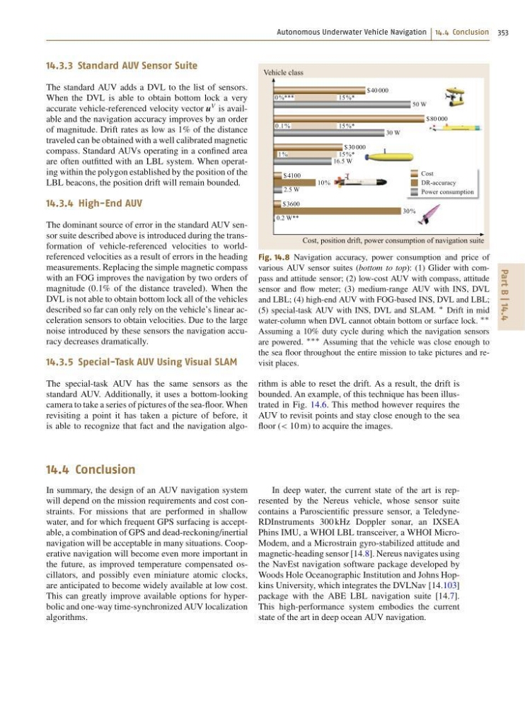
Fig. 14.8 Navigation accuracy, power consumption and price of
various AUV sensor suites (bottom to top): (1) Glider with compass and attitude sensor; (2) low-cost AUV with compass, attitude
sensor and flow meter; (3) medium-range AUV with INS, DVL
and LBL; (4) high-end AUV with FOG-based INS, DVL and LBL;
(5) special-task AUV with INS, DVL and SLAM.
Drift in mid
water-column when DVL cannot obtain bottom or surface lock.
Assuming a 10% duty cycle during which the navigation sensors
are powered.
Assuming that the vehicle was close enough to
the sea floor throughout the entire mission to take pictures and revisit places.
rithm is able to reset the drift. As a result, the drift is
bounded. An example, of this technique has been illustrated in Fig. 14.6. This method however requires the
AUV to revisit points and stay close enough to the sea
floor (< 10 m) to acquire the images.
14.4 Conclusion
In summary, the design of an AUV navigation system
will depend on the mission requirements and cost constraints. For missions that are performed in shallow
water, and for which frequent GPS surfacing is acceptable, a combination of GPS and dead-reckoning/inertial
navigation will be acceptable in many situations. Cooperative navigation will become even more important in
the future, as improved temperature compensated oscillators, and possibly even miniature atomic clocks,
are anticipated to become widely available at low cost.
This can greatly improve available options for hyperbolic and one-way time-synchronized AUV localization
algorithms.
In deep water, the current state of the art is represented by the Nereus vehicle, whose sensor suite
contains a Paroscientific pressure sensor, a TeledyneRDInstruments 300 kHz Doppler sonar, an IXSEA
Phins IMU, a WHOI LBL transceiver, a WHOI MicroModem, and a Microstrain gyro-stabilized attitude and
magnetic-heading sensor [14.8]. Nereus navigates using
the NavEst navigation software package developed by
Woods Hole Oceanographic Institution and Johns Hopkins University, which integrates the DVLNav [14.103]
package with the ABE LBL navigation suite [14.7].
This high-performance system embodies the current
state of the art in deep ocean AUV navigation.
Part B | 14.4
14.3.3 Standard AUV Sensor Suite
The standard AUV adds a DVL to the list of sensors.
When the DVL is able to obtain bottom lock a very
accurate vehicle-referenced velocity vector u
V is available and the navigation accuracy improves by an order
of magnitude. Drift rates as low as 1% of the distance
traveled can be obtained with a well calibrated magnetic
compass. Standard AUVs operating in a confined area
are often outfitted with an LBL system. When operating within the polygon established by the position of the
LBL beacons, the position drift will remain bounded.
14.3.4 High-End AUV
The dominant source of error in the standard AUV sensor suite described above is introduced during the transformation of vehicle-referenced velocities to worldreferenced velocities as a result of errors in the heading
measurements. Replacing the simple magnetic compass
with an FOG improves the navigation by two orders of
magnitude (0:1% of the distance traveled). When the
DVL is not able to obtain bottom lock all of the vehicles
described so far can only rely on the vehicle’s linear acceleration sensors to obtain velocities. Due to the large
noise introduced by these sensors the navigation accuracy decreases dramatically.
14.3.5 Special-Task AUV Using Visual SLAM
The special-task AUV has the same sensors as the
standard AUV. Additionally, it uses a bottom-looking
camera to take a series of pictures of the sea-floor. When
revisiting a point it has taken a picture of before, it
is able to recognize that fact and the navigation algoCost
DR-accuracy
Power consumption
Vehicle class
$ 40 000
50 W
0 %***
15 %*
$ 80 000
30 W
0.1%
15%*
$ 30 000
16.5 W
1 %
15 %*
$ 4100
2.5 W
10 %
$ 3600
0.2 W**
30 %
Cost, position drift, power consumption of navigation suite
Fig. 14.8 Navigation accuracy, power consumption and price of
various AUV sensor suites (bottom to top): (1) Glider with compass and attitude sensor; (2) low-cost AUV with compass, attitude
sensor and flow meter; (3) medium-range AUV with INS, DVL
and LBL; (4) high-end AUV with FOG-based INS, DVL and LBL;
(5) special-task AUV with INS, DVL and SLAM.
Drift in mid
water-column when DVL cannot obtain bottom or surface lock.
Assuming a 10% duty cycle during which the navigation sensors
are powered.
Assuming that the vehicle was close enough to
the sea floor throughout the entire mission to take pictures and revisit places.
rithm is able to reset the drift. As a result, the drift is
bounded. An example, of this technique has been illustrated in Fig. 14.6. This method however requires the
AUV to revisit points and stay close enough to the sea
floor (< 10 m) to acquire the images.
14.4 Conclusion
In summary, the design of an AUV navigation system
will depend on the mission requirements and cost constraints. For missions that are performed in shallow
water, and for which frequent GPS surfacing is acceptable, a combination of GPS and dead-reckoning/inertial
navigation will be acceptable in many situations. Cooperative navigation will become even more important in
the future, as improved temperature compensated oscillators, and possibly even miniature atomic clocks,
are anticipated to become widely available at low cost.
This can greatly improve available options for hyperbolic and one-way time-synchronized AUV localization
algorithms.
In deep water, the current state of the art is represented by the Nereus vehicle, whose sensor suite
contains a Paroscientific pressure sensor, a TeledyneRDInstruments 300 kHz Doppler sonar, an IXSEA
Phins IMU, a WHOI LBL transceiver, a WHOI MicroModem, and a Microstrain gyro-stabilized attitude and
magnetic-heading sensor [14.8]. Nereus navigates using
the NavEst navigation software package developed by
Woods Hole Oceanographic Institution and Johns Hopkins University, which integrates the DVLNav [14.103]
package with the ABE LBL navigation suite [14.7].
This high-performance system embodies the current
state of the art in deep ocean AUV navigation.