

139
Emplacement of HF radar networks operating directional antennae (common
equipment throughout the USA and elsewhere) requires significant forethought and
planning since vector solutions (an explicit numerical expression of the surface current in terms of latitude, longitude, vector bearing, and vector magnitude) requires
the input of two or more radial coincident vectors pointing toward or away from
individual observation posts (antenna sites). Solutions are strongest in the antenna
mid-range and at data points where radial observation pairs are orthogonal (90°) to
one another. Solutions weaken as the angle between signals widens or contracts
becoming indeterminate at small angles and approaching 180° (see Sect. 2.2.3 for a
detailed description of HF radar operation). The planning effort requires maximizing area coverage while avoiding data gaps. Proper positioning maximizes far-field
cover while optimizing field-of-view overlap to minimize the data gaps in the nearshore between observation emplacements, where solutions are weakest. For this
reason, observation posts along linear coastlines are spaced at distances appropriate
to antenna range varying from about 40 km for short-range units to over 100 km for
long-range units. Bays and semi-enclosed water bodies offer the possibility of multiple antennae coverage. Isolated capes may however offer unobstructed fields of
view with effective coverage exceeding 180°. Emplacement on islands within
antenna range can greatly aid in increasing coverage while minimizing the number
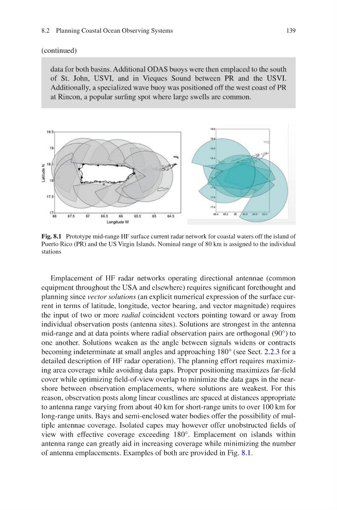
of antenna emplacements. Examples of both are provided in Fig. 8.1.
Fig. 8.1 Prototype mid-range HF surface current radar network for coastal waters off the island of
Puerto Rico (PR) and the US Virgin Islands. Nominal range of 80 km is assigned to the individual
stations
data for both basins. Additional ODAS buoys were then emplaced to the south
of St. John, USVI, and in Vieques Sound between PR and the USVI.
Additionally, a specialized wave buoy was positioned off the west coast of PR
at Rincon, a popular surfing spot where large swells are common.
(continued)
8.2 Planning Coastal Ocean Observing Systems
Emplacement of HF radar networks operating directional antennae (common
equipment throughout the USA and elsewhere) requires significant forethought and
planning since vector solutions (an explicit numerical expression of the surface current in terms of latitude, longitude, vector bearing, and vector magnitude) requires
the input of two or more radial coincident vectors pointing toward or away from
individual observation posts (antenna sites). Solutions are strongest in the antenna
mid-range and at data points where radial observation pairs are orthogonal (90°) to
one another. Solutions weaken as the angle between signals widens or contracts
becoming indeterminate at small angles and approaching 180° (see Sect. 2.2.3 for a
detailed description of HF radar operation). The planning effort requires maximizing area coverage while avoiding data gaps. Proper positioning maximizes far-field
cover while optimizing field-of-view overlap to minimize the data gaps in the nearshore between observation emplacements, where solutions are weakest. For this
reason, observation posts along linear coastlines are spaced at distances appropriate
to antenna range varying from about 40 km for short-range units to over 100 km for
long-range units. Bays and semi-enclosed water bodies offer the possibility of multiple antennae coverage. Isolated capes may however offer unobstructed fields of
view with effective coverage exceeding 180°. Emplacement on islands within
antenna range can greatly aid in increasing coverage while minimizing the number
of antenna emplacements. Examples of both are provided in Fig. 8.1.
Fig. 8.1 Prototype mid-range HF surface current radar network for coastal waters off the island of
Puerto Rico (PR) and the US Virgin Islands. Nominal range of 80 km is assigned to the individual
stations
data for both basins. Additional ODAS buoys were then emplaced to the south
of St. John, USVI, and in Vieques Sound between PR and the USVI.
Additionally, a specialized wave buoy was positioned off the west coast of PR
at Rincon, a popular surfing spot where large swells are common.
(continued)
8.2 Planning Coastal Ocean Observing Systems