

42
Multiscale Hydrologic Remote Sensing: Perspectives and Applications
designed based on the dispersion relationship, in which the dependency of the phase
speed (celerity) of surface waves may be confirmed according to the Doppler effect
on the near-surface current in shallow areas with varying water depth. The implemented method is based on Cartesian images. The first step of the signal processing pipeline consists of the transformation from polar to Cartesian coordinates. The
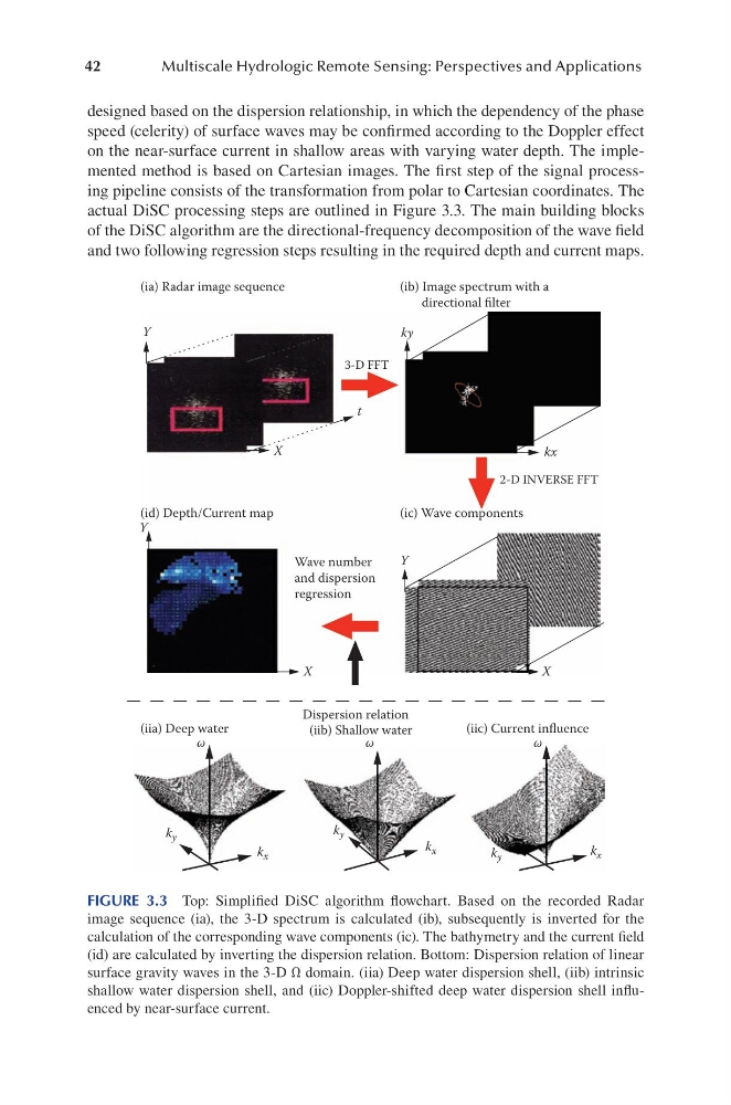
actual DiSC processing steps are outlined in Figure 3.3. The main building blocks
of the DiSC algorithm are the directional-frequency decomposition of the wave field
and two following regression steps resulting in the required depth and current maps.
(ia) Radar image sequence
(ib) Image spectrum with a
directional filter
ky
3-D FFT
2-D INVERSE FFT
t
X
Y
X
ω
k y
k x
k x
k y
k y
k x
ω
ω
X
Y
Y
kx
(id) Depth/Current map
(iia) Deep water
(iib) Shallow water
(iic) Current influence
(ic) Wave components
Wave number
and dispersion
regression
Dispersion relation
FIGURE 3.3 Top: Simplified DiSC algorithm flowchart. Based on the recorded Radar
image sequence (ia), the 3-D spectrum is calculated (ib), subsequently is inverted for the
calculation of the corresponding wave components (ic). The bathymetry and the current field
(id) are calculated by inverting the dispersion relation. Bottom: Dispersion relation of linear
surface gravity waves in the 3-D Ω domain. (iia) Deep water dispersion shell, (iib) intrinsic
shallow water dispersion shell, and (iic) Doppler-shifted deep water dispersion shell influenced by near-surface current.
Multiscale Hydrologic Remote Sensing: Perspectives and Applications
designed based on the dispersion relationship, in which the dependency of the phase
speed (celerity) of surface waves may be confirmed according to the Doppler effect
on the near-surface current in shallow areas with varying water depth. The implemented method is based on Cartesian images. The first step of the signal processing pipeline consists of the transformation from polar to Cartesian coordinates. The
actual DiSC processing steps are outlined in Figure 3.3. The main building blocks
of the DiSC algorithm are the directional-frequency decomposition of the wave field
and two following regression steps resulting in the required depth and current maps.
(ia) Radar image sequence
(ib) Image spectrum with a
directional filter
ky
3-D FFT
2-D INVERSE FFT
t
X
Y
X
ω
k y
k x
k x
k y
k y
k x
ω
ω
X
Y
Y
kx
(id) Depth/Current map
(iia) Deep water
(iib) Shallow water
(iic) Current influence
(ic) Wave components
Wave number
and dispersion
regression
Dispersion relation
FIGURE 3.3 Top: Simplified DiSC algorithm flowchart. Based on the recorded Radar
image sequence (ia), the 3-D spectrum is calculated (ib), subsequently is inverted for the
calculation of the corresponding wave components (ic). The bathymetry and the current field
(id) are calculated by inverting the dispersion relation. Bottom: Dispersion relation of linear
surface gravity waves in the 3-D Ω domain. (iia) Deep water dispersion shell, (iib) intrinsic
shallow water dispersion shell, and (iic) Doppler-shifted deep water dispersion shell influenced by near-surface current.