

406
Multiscale Hydrologic Remote Sensing: Perspectives and Applications
Additionally, the spatial information of soil moisture provided by AMSR-E remotely
sensed data has considerable potential to improve hydrological prediction at large
scale. The anticipated SMAP mission is expected to be better suited than the current
AMSR-E for hydrological simulation.
In a recent validation study of SMOS soil moisture product, Juglea et al. (2010)
simulated the soil moisture of a whole SMOS pixel at 50 × 50 km in Spain for the
period 2004–2008 using a land surface model called Soil–Vegetation–Atmosphere–
Transfer (SVAT). Ground and meteorological measurements over the 50-km grid
area are used as the inputs to the SVAT model, and the simulated results are compared with ground in situ soil moisture observations and remote sensing soil moisture
data from the AMSR-E and the European Remote Sensing Satellites Scatterometers.
Juglea et al. (2010) concluded that the SVAT model simulated soil moisture data are
adequate for validating the SMOS soil moisture estimation and also expected future
works of simulating the SMOIS brightness temperature into the SVAT model as part
of the SMOS validation activities.
17.5 CONCLUSIONS
This chapter summarized the satellite remote sensing sensors commonly used
for soil moisture estimation, with a particular focus on microwave remote sensing methods. Both passive and active microwave remote sensing methods are
(a) AMSR-E daily effective data count in 2005 (days)
300
200
100
0
(b) Correlation coefficient
0.5
0.4
0.3
0.2
0.1
0 0
3
6
9
12
API (days)
Corr. coeff.
15
18
21
24
27
30
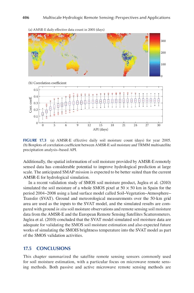
FIGURE 17.3 (a) AMSR-E effective daily soil moisture count (days) for year 2005.
(b) Boxplots of correlation coefficient between AMSR-E soil moisture and TRMM multisatellite
precipitation analysis–based API.
Multiscale Hydrologic Remote Sensing: Perspectives and Applications
Additionally, the spatial information of soil moisture provided by AMSR-E remotely
sensed data has considerable potential to improve hydrological prediction at large
scale. The anticipated SMAP mission is expected to be better suited than the current
AMSR-E for hydrological simulation.
In a recent validation study of SMOS soil moisture product, Juglea et al. (2010)
simulated the soil moisture of a whole SMOS pixel at 50 × 50 km in Spain for the
period 2004–2008 using a land surface model called Soil–Vegetation–Atmosphere–
Transfer (SVAT). Ground and meteorological measurements over the 50-km grid
area are used as the inputs to the SVAT model, and the simulated results are compared with ground in situ soil moisture observations and remote sensing soil moisture
data from the AMSR-E and the European Remote Sensing Satellites Scatterometers.
Juglea et al. (2010) concluded that the SVAT model simulated soil moisture data are
adequate for validating the SMOS soil moisture estimation and also expected future
works of simulating the SMOIS brightness temperature into the SVAT model as part
of the SMOS validation activities.
17.5 CONCLUSIONS
This chapter summarized the satellite remote sensing sensors commonly used
for soil moisture estimation, with a particular focus on microwave remote sensing methods. Both passive and active microwave remote sensing methods are
(a) AMSR-E daily effective data count in 2005 (days)
300
200
100
0
(b) Correlation coefficient
0.5
0.4
0.3
0.2
0.1
0 0
3
6
9
12
API (days)
Corr. coeff.
15
18
21
24
27
30
FIGURE 17.3 (a) AMSR-E effective daily soil moisture count (days) for year 2005.
(b) Boxplots of correlation coefficient between AMSR-E soil moisture and TRMM multisatellite
precipitation analysis–based API.