

21
Advanced Ground-Penetrating Radar for Soil Moisture Retrieval
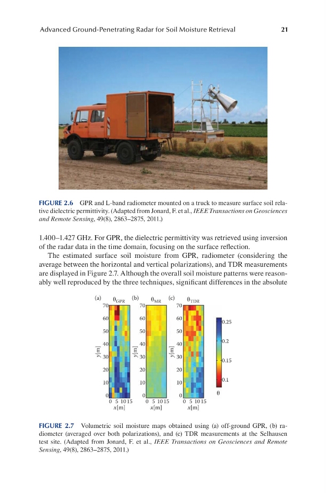
1.400–1.427 GHz. For GPR, the dielectric permittivity was retrieved using inversion
of the radar data in the time domain, focusing on the surface reflection.
The estimated surface soil moisture from GPR, radiometer (considering the
average between the horizontal and vertical polarizations), and TDR measurements
are displayed in Figure 2.7. Although the overall soil moisture patterns were reasonably well reproduced by the three techniques, significant differences in the absolute
FIGURE 2.6 GPR and L-band radiometer mounted on a truck to measure surface soil relative dielectric permittivity. (Adapted from Jonard, F. et al., IEEE Transactions on Geosciences
and Remote Sensing, 49(8), 2863–2875, 2011.)
70
60
50
40
y[m]
(a)
30
20
10
0
70
60
50
40
y[m]
30
20
10
0
70
60
50
40
y[m]
30
20
10
0
x[m]
0 5 10 15
x[m]
0 5 10 15
x[m]
0 5 10 15
θ GPR
(b)
(c)
θ MR
θ TDR
0.25
0.2
0.15
0.1
θ
FIGURE 2.7 Volumetric soil moisture maps obtained using (a) off-ground GPR, (b) ra -
diometer (averaged over both polarizations), and (c) TDR measurements at the Selhausen
test site. (Adapted from Jonard, F. et al., IEEE Transactions on Geosciences and Remote
Sensing, 49(8), 2863–2875, 2011.)
Advanced Ground-Penetrating Radar for Soil Moisture Retrieval
1.400–1.427 GHz. For GPR, the dielectric permittivity was retrieved using inversion
of the radar data in the time domain, focusing on the surface reflection.
The estimated surface soil moisture from GPR, radiometer (considering the
average between the horizontal and vertical polarizations), and TDR measurements
are displayed in Figure 2.7. Although the overall soil moisture patterns were reasonably well reproduced by the three techniques, significant differences in the absolute
FIGURE 2.6 GPR and L-band radiometer mounted on a truck to measure surface soil relative dielectric permittivity. (Adapted from Jonard, F. et al., IEEE Transactions on Geosciences
and Remote Sensing, 49(8), 2863–2875, 2011.)
70
60
50
40
y[m]
(a)
30
20
10
0
70
60
50
40
y[m]
30
20
10
0
70
60
50
40
y[m]
30
20
10
0
x[m]
0 5 10 15
x[m]
0 5 10 15
x[m]
0 5 10 15
θ GPR
(b)
(c)
θ MR
θ TDR
0.25
0.2
0.15
0.1
θ
FIGURE 2.7 Volumetric soil moisture maps obtained using (a) off-ground GPR, (b) ra -
diometer (averaged over both polarizations), and (c) TDR measurements at the Selhausen
test site. (Adapted from Jonard, F. et al., IEEE Transactions on Geosciences and Remote
Sensing, 49(8), 2863–2875, 2011.)