

347
Airborne Water Vapor Differential Absorption Lidar
14.3.1.4 Application Examples
The latest field campaign that LEANDRE II participated in is the International H 2 O
Project (IHOP_2002). It took place over the Southern Great Plains of the United
States from May 13 to June 25, 2002. The main objective of this field campaign
was to determine if improved measurements of water vapor lead to a corresponding
improvement in our ability to predict convective rainfall amounts. In this project, the
LEANDRE II DIAL system was equipped on an NRL P-3 aircraft and accomplished
24 missions (total of 142-h scientific flights).
During the missions for bores investigation, the vertical structure of the bore
was investigated with the nadir-pointing DIAL LEANDRE II from an altitude of
4.5 km mean sea level (MSL) on June 20, 2002, Oklahoma panhandle (Flamamt et
al. 2004). The evolution of the bore was best captured along the westernmost north–
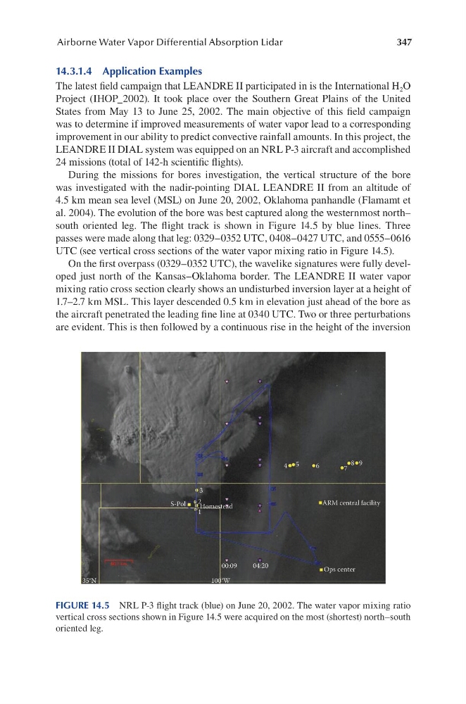
south oriented leg. The flight track is shown in Figure 14.5 by blue lines. Three
passes were made along that leg: 0329–0352 UTC, 0408–0427 UTC, and 0555–0616
UTC (see vertical cross sections of the water vapor mixing ratio in Figure 14.5).
On the first overpass (0329–0352 UTC), the wavelike signatures were fully developed just north of the Kansas–Oklahoma border. The LEANDRE II water vapor
mixing ratio cross section clearly shows an undisturbed inversion layer at a height of
1.7–2.7 km MSL. This layer descended 0.5 km in elevation just ahead of the bore as
the aircraft penetrated the leading fine line at 0340 UTC. Two or three perturbations
are evident. This is then followed by a continuous rise in the height of the inversion
4 5
3
2
1
S-Pol
Homestead
ARM central facility
Ops center
00:09
100°W
35°N
04:20
6
7
8 9
FIGURE 14.5 NRL P-3 flight track (blue) on June 20, 2002. The water vapor mixing ratio
vertical cross sections shown in Figure 14.5 were acquired on the most (shortest) north–south
oriented leg.
Airborne Water Vapor Differential Absorption Lidar
14.3.1.4 Application Examples
The latest field campaign that LEANDRE II participated in is the International H 2 O
Project (IHOP_2002). It took place over the Southern Great Plains of the United
States from May 13 to June 25, 2002. The main objective of this field campaign
was to determine if improved measurements of water vapor lead to a corresponding
improvement in our ability to predict convective rainfall amounts. In this project, the
LEANDRE II DIAL system was equipped on an NRL P-3 aircraft and accomplished
24 missions (total of 142-h scientific flights).
During the missions for bores investigation, the vertical structure of the bore
was investigated with the nadir-pointing DIAL LEANDRE II from an altitude of
4.5 km mean sea level (MSL) on June 20, 2002, Oklahoma panhandle (Flamamt et
al. 2004). The evolution of the bore was best captured along the westernmost north–
south oriented leg. The flight track is shown in Figure 14.5 by blue lines. Three
passes were made along that leg: 0329–0352 UTC, 0408–0427 UTC, and 0555–0616
UTC (see vertical cross sections of the water vapor mixing ratio in Figure 14.5).
On the first overpass (0329–0352 UTC), the wavelike signatures were fully developed just north of the Kansas–Oklahoma border. The LEANDRE II water vapor
mixing ratio cross section clearly shows an undisturbed inversion layer at a height of
1.7–2.7 km MSL. This layer descended 0.5 km in elevation just ahead of the bore as
the aircraft penetrated the leading fine line at 0340 UTC. Two or three perturbations
are evident. This is then followed by a continuous rise in the height of the inversion
4 5
3
2
1
S-Pol
Homestead
ARM central facility
Ops center
00:09
100°W
35°N
04:20
6
7
8 9
FIGURE 14.5 NRL P-3 flight track (blue) on June 20, 2002. The water vapor mixing ratio
vertical cross sections shown in Figure 14.5 were acquired on the most (shortest) north–south
oriented leg.