

263
Multispectral Satellite Data for Flood Monitoring and Inundation Mapping
FAR is substantially reduced to as low as 0.15. The CSI is improved from 0.19 at 30
m to more than 0.76 at a radius of 600 m.
11.5 CONCLUSIONS
To characterize the spatial extents of flooding over sparsely gauged or ungauged
basins, this study compared the best available remote sensing images with the modeling outputs derived by a well-calibrated hydrologic model—CREST. Practical
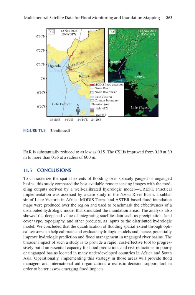
implementation was assessed by a case study in the Nzoia River Basin, a subbasin of Lake Victoria in Africa. MODIS Terra- and ASTER-based flood inundation
maps were produced over the region and used to benchmark the effectiveness of a
distributed hydrologic model that simulated the inundation areas. The analysis also
showed the deepened value of integrating satellite data such as precipitation, land
cover type, topography, and other products, as inputs to the distributed hydrologic
model. We concluded that the quantification of flooding spatial extent through optical sensors can help calibrate and evaluate hydrologic models and, hence, potentially
improve hydrologic prediction and flood management in ungauged river basins. The
broader impact of such a study is to provide a rapid, cost-effective tool to progressively build an essential capacity for flood predictions and risk reductions in poorly
or ungauged basins located in many underdeveloped countries in Africa and South
Asia. Operationally, implementing this strategy in those areas will provide flood
managers and international aid organizations a realistic decision support tool in
order to better assess emerging flood impacts.
33°50'E 34°0'E 34°10'E 34°20'E
0°30'N
0°20'N
0°10'N
0°10'S
0°20'S
0°0'
MODIS flood detection
Nzoia River
Nzoia River basin
Lake Victoria
Country boundary
High: 4122
Low: 952
Elevation (m)
Lake Victoria
Kenya
Kenya
Uganda
Uganda
Lake Victoria
N z o ia R iv e r
12 Nov 2008
(DOY 317)
12 Nov 2008
(DOY 317)
(e1)
(e2)
N
FIGURE 11.3 (Continued)
Multispectral Satellite Data for Flood Monitoring and Inundation Mapping
FAR is substantially reduced to as low as 0.15. The CSI is improved from 0.19 at 30
m to more than 0.76 at a radius of 600 m.
11.5 CONCLUSIONS
To characterize the spatial extents of flooding over sparsely gauged or ungauged
basins, this study compared the best available remote sensing images with the modeling outputs derived by a well-calibrated hydrologic model—CREST. Practical
implementation was assessed by a case study in the Nzoia River Basin, a subbasin of Lake Victoria in Africa. MODIS Terra- and ASTER-based flood inundation
maps were produced over the region and used to benchmark the effectiveness of a
distributed hydrologic model that simulated the inundation areas. The analysis also
showed the deepened value of integrating satellite data such as precipitation, land
cover type, topography, and other products, as inputs to the distributed hydrologic
model. We concluded that the quantification of flooding spatial extent through optical sensors can help calibrate and evaluate hydrologic models and, hence, potentially
improve hydrologic prediction and flood management in ungauged river basins. The
broader impact of such a study is to provide a rapid, cost-effective tool to progressively build an essential capacity for flood predictions and risk reductions in poorly
or ungauged basins located in many underdeveloped countries in Africa and South
Asia. Operationally, implementing this strategy in those areas will provide flood
managers and international aid organizations a realistic decision support tool in
order to better assess emerging flood impacts.
33°50'E 34°0'E 34°10'E 34°20'E
0°30'N
0°20'N
0°10'N
0°10'S
0°20'S
0°0'
MODIS flood detection
Nzoia River
Nzoia River basin
Lake Victoria
Country boundary
High: 4122
Low: 952
Elevation (m)
Lake Victoria
Kenya
Kenya
Uganda
Uganda
Lake Victoria
N z o ia R iv e r
12 Nov 2008
(DOY 317)
12 Nov 2008
(DOY 317)
(e1)
(e2)
N
FIGURE 11.3 (Continued)