

238
Multiscale Hydrologic Remote Sensing: Perspectives and Applications
10.4.6 cliMate change
The focus of this research is to project the range of likely impacts of climate change
on the water supply and distribution across the Snake River Plain of southern Idaho.
Given the high degree of uncertainty in future climate, a broad range of modelprojected climate change scenarios were incorporated into this analysis. The scenarios used were selected from among the output from running 18 different models
for the Intergovernmental Panel on Climate Change (IPCC) in preparation for the
IPCC Fourth Assessment Report (AR4; http://www.ipcc.ch/publications_and_data/
publications_and_data_reports.shtml). Each model was run using a variety of carbon emission scenarios developed by the IPCC. The A1B emission scenario was
developed based on an economic rather than environmental focus, assuming rapid
global economic growth in which income and social and cultural interactions converge between regions and assuming a balanced emphasis on carbon and noncarbon
emitting energy sources, especially after the year 2050. In this scenario, world population is anticipated to peak at 9 billion in 2050 and then decline gradually. In this
study, results obtained from a general circulation model (GCM) corresponding to the
A1B emission scenario were used.
A comparison of the output from the collection of GCMs showed that greater
uncertainty existed for precipitation than for temperature. Therefore, in order to
encompass a wide range of possible outcomes for this region, precipitation was used
as the differentiating variable regarding which GCMs output to select for use in this
research. Three internationally recognized GCMs were selected, which captured a
wide range of change in precipitation, approximating the 10%, 50%, and 90% probability density function quantiles developed by the National Center for Atmospheric
Research (NCAR) from the output of the 18 GCMs run for the IPCC AR4. These
were called the “DRY,” “MID,” and “WET” models, respectively. The selected
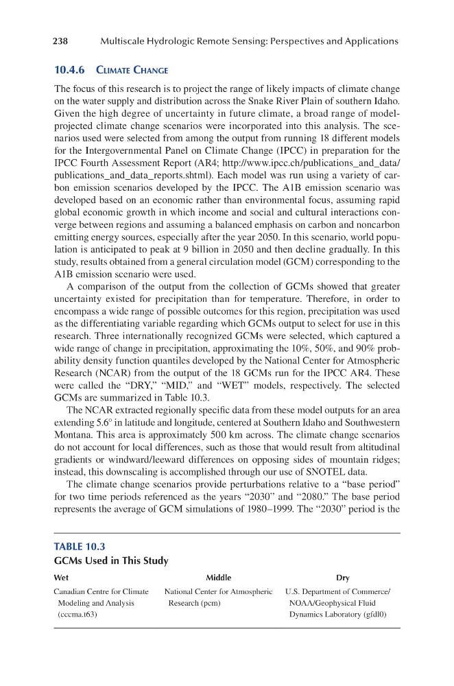
GCMs are summarized in Table 10.3.
The NCAR extracted regionally specific data from these model outputs for an area
extending 5.6° in latitude and longitude, centered at Southern Idaho and Southwestern
Montana. This area is approximately 500 km across. The climate change scenarios
do not account for local differences, such as those that would result from altitudinal
gradients or windward/leeward differences on opposing sides of mountain ridges;
instead, this downscaling is accomplished through our use of SNOTEL data.
The climate change scenarios provide perturbations relative to a “base period”
for two time periods referenced as the years “2030” and “2080.” The base period
represents the average of GCM simulations of 1980–1999. The “2030” period is the
TABLE 10.3
GCMs Used in This Study
Wet
Middle
Dry
Canadian Centre for Climate
Modeling and Analysis
(cccma.t63)
National Center for Atmospheric
Research (pcm)
U.S. Department of Commerce/
NOAA/Geophysical Fluid
Dynamics Laboratory (gfdl0)
Multiscale Hydrologic Remote Sensing: Perspectives and Applications
10.4.6 cliMate change
The focus of this research is to project the range of likely impacts of climate change
on the water supply and distribution across the Snake River Plain of southern Idaho.
Given the high degree of uncertainty in future climate, a broad range of modelprojected climate change scenarios were incorporated into this analysis. The scenarios used were selected from among the output from running 18 different models
for the Intergovernmental Panel on Climate Change (IPCC) in preparation for the
IPCC Fourth Assessment Report (AR4; http://www.ipcc.ch/publications_and_data/
publications_and_data_reports.shtml). Each model was run using a variety of carbon emission scenarios developed by the IPCC. The A1B emission scenario was
developed based on an economic rather than environmental focus, assuming rapid
global economic growth in which income and social and cultural interactions converge between regions and assuming a balanced emphasis on carbon and noncarbon
emitting energy sources, especially after the year 2050. In this scenario, world population is anticipated to peak at 9 billion in 2050 and then decline gradually. In this
study, results obtained from a general circulation model (GCM) corresponding to the
A1B emission scenario were used.
A comparison of the output from the collection of GCMs showed that greater
uncertainty existed for precipitation than for temperature. Therefore, in order to
encompass a wide range of possible outcomes for this region, precipitation was used
as the differentiating variable regarding which GCMs output to select for use in this
research. Three internationally recognized GCMs were selected, which captured a
wide range of change in precipitation, approximating the 10%, 50%, and 90% probability density function quantiles developed by the National Center for Atmospheric
Research (NCAR) from the output of the 18 GCMs run for the IPCC AR4. These
were called the “DRY,” “MID,” and “WET” models, respectively. The selected
GCMs are summarized in Table 10.3.
The NCAR extracted regionally specific data from these model outputs for an area
extending 5.6° in latitude and longitude, centered at Southern Idaho and Southwestern
Montana. This area is approximately 500 km across. The climate change scenarios
do not account for local differences, such as those that would result from altitudinal
gradients or windward/leeward differences on opposing sides of mountain ridges;
instead, this downscaling is accomplished through our use of SNOTEL data.
The climate change scenarios provide perturbations relative to a “base period”
for two time periods referenced as the years “2030” and “2080.” The base period
represents the average of GCM simulations of 1980–1999. The “2030” period is the
TABLE 10.3
GCMs Used in This Study
Wet
Middle
Dry
Canadian Centre for Climate
Modeling and Analysis
(cccma.t63)
National Center for Atmospheric
Research (pcm)
U.S. Department of Commerce/
NOAA/Geophysical Fluid
Dynamics Laboratory (gfdl0)