

225
Modeling Snowmelt Runoff under Climate Change Scenarios
differences between cloud and snow/ice reflectance and emission properties (http://
ndsic.org/data/docs/daad/mod10a2_modis_terra_snow_8-day).
To calculate the NDSI, the automated snow mapping algorithm uses at-satellite
reflectance in MODIS bands 4 (0.545–0.565) and 6 (0.628–1.652) for Terra data,
whereas bands 4 and 7 are used in calculating the NDSI for Aqua data (Hall and
Riggs 2007; Parajka and Blöschl 2008b):
NDSI = (MODIS4 – MODIS6)/(MODIS4 + MODIS6) (for Terra data) (10.6)
NDSI = (MODIS4 – MODIS7)/(MODIS4 + MODIS7) (for Aqua data). (10.7)
The adoption of band 7 in the Aqua MODIS algorithms was a result of the failure
of a larger percentage of band 6 detectors on the Aqua MODIS shortly after launch.
Unforested pixels where the NDSI ≥ 0.4 and band 2 (0.841 – 0.876 μm) reflectance >
0.11 are mapped as snow covered (Molotch and Margulis 2008). The mapping of snow
cover becomes limited in areas with dense forest canopies. In forest canopies, eventually, the snow falls off the canopy to the ground, where it is difficult to detect (Hall et al.
2006). In order to overcome this problem, the NDSI and the normalized difference vegetation index (NDVI) are used together for snow mapping in forested locations (Hall
et al. 1998). However, the combination of NDSI and NDVI is only useful for forestland
snow mapping with Terra data; it cannot be applied to Aqua data due to increased false
snow detection observed when applied to Aqua imagery (Hall et al. 2006).
Parajka and Blöschl (2008a) summarize the conclusions of various studies conducted on the accuracy of MODIS into two points. First, MODIS snow cover products
are very accurate (~93%) in estimating snow cover extent under clear-sky conditions
(Hall and Riggs 2007), but the degree of accuracy varies by land cover type and
snow condition. The accuracy of MODIS under clear-sky conditions was found to be
95% in a study conducted by Parajka and Blöschl (2006) over Austria and about 94%
in a study by Hall and Riggs (2007). Wang et al. (2008) also reported an accuracy
of 94% for snow and 99% for land when compared with ground-based SD measurements. This advantage has made MODIS the preferred product of several researchers
who have used it in estimating snow cover extent across different parts of the world.
Snow
Open water
Land
Cloud
Missing data
Night observation
Mask
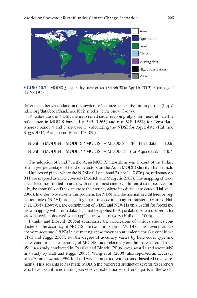
FIGURE 10.2 MODIS global 8-day snow extent (March 30 to April 6, 2003). (Courtesy of
the NSIDC.)
Modeling Snowmelt Runoff under Climate Change Scenarios
differences between cloud and snow/ice reflectance and emission properties (http://
ndsic.org/data/docs/daad/mod10a2_modis_terra_snow_8-day).
To calculate the NDSI, the automated snow mapping algorithm uses at-satellite
reflectance in MODIS bands 4 (0.545–0.565) and 6 (0.628–1.652) for Terra data,
whereas bands 4 and 7 are used in calculating the NDSI for Aqua data (Hall and
Riggs 2007; Parajka and Blöschl 2008b):
NDSI = (MODIS4 – MODIS6)/(MODIS4 + MODIS6) (for Terra data) (10.6)
NDSI = (MODIS4 – MODIS7)/(MODIS4 + MODIS7) (for Aqua data). (10.7)
The adoption of band 7 in the Aqua MODIS algorithms was a result of the failure
of a larger percentage of band 6 detectors on the Aqua MODIS shortly after launch.
Unforested pixels where the NDSI ≥ 0.4 and band 2 (0.841 – 0.876 μm) reflectance >
0.11 are mapped as snow covered (Molotch and Margulis 2008). The mapping of snow
cover becomes limited in areas with dense forest canopies. In forest canopies, eventually, the snow falls off the canopy to the ground, where it is difficult to detect (Hall et al.
2006). In order to overcome this problem, the NDSI and the normalized difference vegetation index (NDVI) are used together for snow mapping in forested locations (Hall
et al. 1998). However, the combination of NDSI and NDVI is only useful for forestland
snow mapping with Terra data; it cannot be applied to Aqua data due to increased false
snow detection observed when applied to Aqua imagery (Hall et al. 2006).
Parajka and Blöschl (2008a) summarize the conclusions of various studies conducted on the accuracy of MODIS into two points. First, MODIS snow cover products
are very accurate (~93%) in estimating snow cover extent under clear-sky conditions
(Hall and Riggs 2007), but the degree of accuracy varies by land cover type and
snow condition. The accuracy of MODIS under clear-sky conditions was found to be
95% in a study conducted by Parajka and Blöschl (2006) over Austria and about 94%
in a study by Hall and Riggs (2007). Wang et al. (2008) also reported an accuracy
of 94% for snow and 99% for land when compared with ground-based SD measurements. This advantage has made MODIS the preferred product of several researchers
who have used it in estimating snow cover extent across different parts of the world.
Snow
Open water
Land
Cloud
Missing data
Night observation
Mask
FIGURE 10.2 MODIS global 8-day snow extent (March 30 to April 6, 2003). (Courtesy of
the NSIDC.)