

204
Multiscale Hydrologic Remote Sensing: Perspectives and Applications
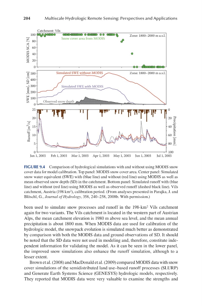
been used to simulate snow processes and runoff in the 198-km 2 Vils catchment
again for two variants. The Vils catchment is located in the western part of Austrian
Alps, the mean catchment elevation is 1980 m above sea level, and the mean annual
precipitation is about 1800 mm. When MODIS data are used for calibration of the
hydrologic model, the snowpack evolution is simulated much better as demonstrated
by comparison with both the MODIS data and ground observations of SD. It should
be noted that the SD data were not used in modeling and, therefore, constitute independent information for validating the model. As it can be seen in the lower panel,
the improved snow simulations also enhance the runoff simulation, although to a
lesser extent.
Brown et al. (2008) and MacDonald et al. (2009) compared MODIS data with snow
cover simulations of the semidistributed land use–based runoff processes (SLURP)
and Generate Earth Systems Science (GENESYS) hydrologic models, respectively.
They reported that MODIS data were very valuable to examine the strengths and
Jan 1, 2003
Feb 1, 2003 Mar 1, 2003 Apr 1, 2003 May 1, 2003 Jun 1, 2003
Jul 1, 2003
0
5
10
15
20
25
Runoff [m 3
/s]
100
80
60
40
20
0
Precipitation [mm]
0
100
200
300
400
500
SWE [mm], SD [cm]
Zone: 1800–2000 m a.s.l.
0
20
40
60
80
100
MODIS SCA [%]
Zone: 1800–2000 m a.s.l.
Catchment: Vils
Simulated SWE without MODIS
Simulated SWE with MODIS
Observed snow depth
Snow cover area from MODIS
FIGURE 9.4 Comparison of hydrological simulations with and without using MODIS snow
cover data for model calibration. Top panel: MODIS snow cover area. Center panel: Simulated
snow water equivalent (SWE) with (blue line) and without (red line) using MODIS as well as
mean observed snow depth (SD) in the catchment. Bottom panel: Simulated runoff with (blue
line) and without (red line) using MODIS as well as observed runoff (dashed black line). Vils
catchment, Austria (198 km 2 ), calibration period. (From analyses presented in Parajka, J. and
Blöschl, G., Journal of Hydrology, 358, 240–258, 2008b. With permission.)
Multiscale Hydrologic Remote Sensing: Perspectives and Applications
been used to simulate snow processes and runoff in the 198-km 2 Vils catchment
again for two variants. The Vils catchment is located in the western part of Austrian
Alps, the mean catchment elevation is 1980 m above sea level, and the mean annual
precipitation is about 1800 mm. When MODIS data are used for calibration of the
hydrologic model, the snowpack evolution is simulated much better as demonstrated
by comparison with both the MODIS data and ground observations of SD. It should
be noted that the SD data were not used in modeling and, therefore, constitute independent information for validating the model. As it can be seen in the lower panel,
the improved snow simulations also enhance the runoff simulation, although to a
lesser extent.
Brown et al. (2008) and MacDonald et al. (2009) compared MODIS data with snow
cover simulations of the semidistributed land use–based runoff processes (SLURP)
and Generate Earth Systems Science (GENESYS) hydrologic models, respectively.
They reported that MODIS data were very valuable to examine the strengths and
Jan 1, 2003
Feb 1, 2003 Mar 1, 2003 Apr 1, 2003 May 1, 2003 Jun 1, 2003
Jul 1, 2003
0
5
10
15
20
25
Runoff [m 3
/s]
100
80
60
40
20
0
Precipitation [mm]
0
100
200
300
400
500
SWE [mm], SD [cm]
Zone: 1800–2000 m a.s.l.
0
20
40
60
80
100
MODIS SCA [%]
Zone: 1800–2000 m a.s.l.
Catchment: Vils
Simulated SWE without MODIS
Simulated SWE with MODIS
Observed snow depth
Snow cover area from MODIS
FIGURE 9.4 Comparison of hydrological simulations with and without using MODIS snow
cover data for model calibration. Top panel: MODIS snow cover area. Center panel: Simulated
snow water equivalent (SWE) with (blue line) and without (red line) using MODIS as well as
mean observed snow depth (SD) in the catchment. Bottom panel: Simulated runoff with (blue
line) and without (red line) using MODIS as well as observed runoff (dashed black line). Vils
catchment, Austria (198 km 2 ), calibration period. (From analyses presented in Parajka, J. and
Blöschl, G., Journal of Hydrology, 358, 240–258, 2008b. With permission.)