

192
Multiscale Hydrologic Remote Sensing: Perspectives and Applications
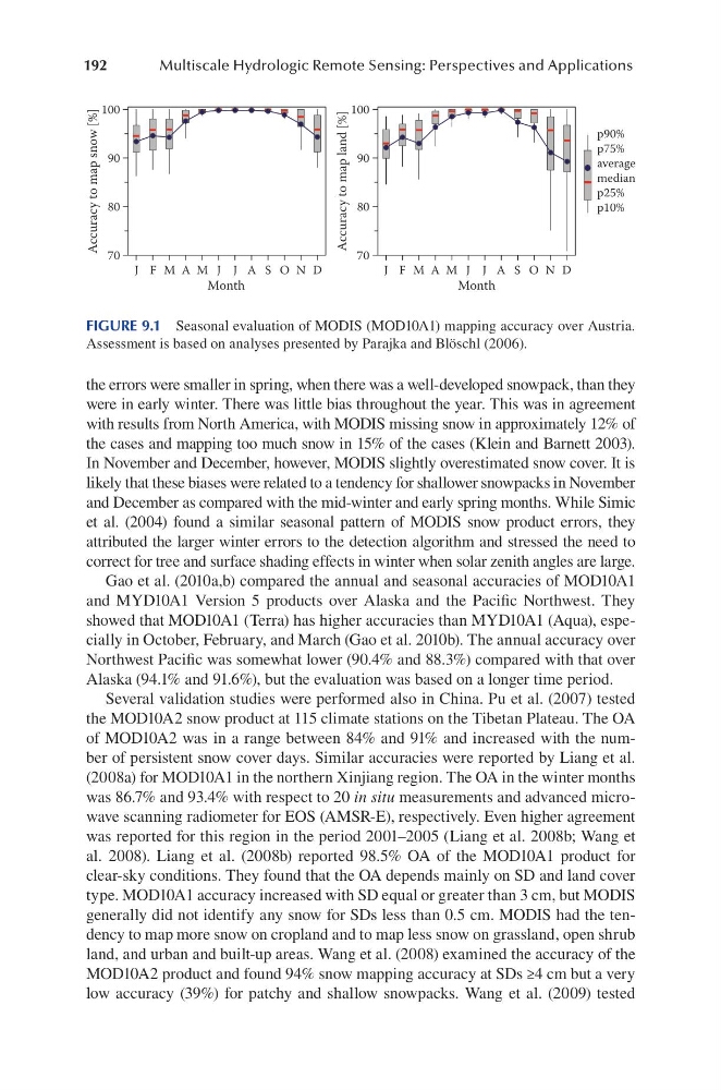
the errors were smaller in spring, when there was a well-developed snowpack, than they
were in early winter. There was little bias throughout the year. This was in agreement
with results from North America, with MODIS missing snow in approximately 12% of
the cases and mapping too much snow in 15% of the cases (Klein and Barnett 2003).
In November and December, however, MODIS slightly overestimated snow cover. It is
likely that these biases were related to a tendency for shallower snowpacks in November
and December as compared with the mid-winter and early spring months. While Simic
et al. (2004) found a similar seasonal pattern of MODIS snow product errors, they
attributed the larger winter errors to the detection algorithm and stressed the need to
correct for tree and surface shading effects in winter when solar zenith angles are large.
Gao et al. (2010a,b) compared the annual and seasonal accuracies of MOD10A1
and MYD10A1 Version 5 products over Alaska and the Pacific Northwest. They
showed that MOD10A1 (Terra) has higher accuracies than MYD10A1 (Aqua), especially in October, February, and March (Gao et al. 2010b). The annual accuracy over
Northwest Pacific was somewhat lower (90.4% and 88.3%) compared with that over
Alaska (94.1% and 91.6%), but the evaluation was based on a longer time period.
Several validation studies were performed also in China. Pu et al. (2007) tested
the MOD10A2 snow product at 115 climate stations on the Tibetan Plateau. The OA
of MOD10A2 was in a range between 84% and 91% and increased with the number of persistent snow cover days. Similar accuracies were reported by Liang et al.
(2008a) for MOD10A1 in the northern Xinjiang region. The OA in the winter months
was 86.7% and 93.4% with respect to 20 in situ measurements and advanced microwave scanning radiometer for EOS (AMSR-E), respectively. Even higher agreement
was reported for this region in the period 2001–2005 (Liang et al. 2008b; Wang et
al. 2008). Liang et al. (2008b) reported 98.5% OA of the MOD10A1 product for
clear-sky conditions. They found that the OA depends mainly on SD and land cover
type. MOD10A1 accuracy increased with SD equal or greater than 3 cm, but MODIS
generally did not identify any snow for SDs less than 0.5 cm. MODIS had the tendency to map more snow on cropland and to map less snow on grassland, open shrub
land, and urban and built-up areas. Wang et al. (2008) examined the accuracy of the
MOD10A2 product and found 94% snow mapping accuracy at SDs ≥4 cm but a very
low accuracy (39%) for patchy and shallow snowpacks. Wang et al. (2009) tested
J
M
M
J
S
N
F
A
J
A
O
D
Month
J
M
M
J
S
N
F
A
J
A
O
D
Month
70
80
90
100
Accuracy to map snow [%]
70
80
90
100
Accuracy to map land [%]
p90%
p75%
average
median
p25%
p10%
FIGURE 9.1 Seasonal evaluation of MODIS (MOD10A1) mapping accuracy over Austria.
Assessment is based on analyses presented by Parajka and Blöschl (2006).
Multiscale Hydrologic Remote Sensing: Perspectives and Applications
the errors were smaller in spring, when there was a well-developed snowpack, than they
were in early winter. There was little bias throughout the year. This was in agreement
with results from North America, with MODIS missing snow in approximately 12% of
the cases and mapping too much snow in 15% of the cases (Klein and Barnett 2003).
In November and December, however, MODIS slightly overestimated snow cover. It is
likely that these biases were related to a tendency for shallower snowpacks in November
and December as compared with the mid-winter and early spring months. While Simic
et al. (2004) found a similar seasonal pattern of MODIS snow product errors, they
attributed the larger winter errors to the detection algorithm and stressed the need to
correct for tree and surface shading effects in winter when solar zenith angles are large.
Gao et al. (2010a,b) compared the annual and seasonal accuracies of MOD10A1
and MYD10A1 Version 5 products over Alaska and the Pacific Northwest. They
showed that MOD10A1 (Terra) has higher accuracies than MYD10A1 (Aqua), especially in October, February, and March (Gao et al. 2010b). The annual accuracy over
Northwest Pacific was somewhat lower (90.4% and 88.3%) compared with that over
Alaska (94.1% and 91.6%), but the evaluation was based on a longer time period.
Several validation studies were performed also in China. Pu et al. (2007) tested
the MOD10A2 snow product at 115 climate stations on the Tibetan Plateau. The OA
of MOD10A2 was in a range between 84% and 91% and increased with the number of persistent snow cover days. Similar accuracies were reported by Liang et al.
(2008a) for MOD10A1 in the northern Xinjiang region. The OA in the winter months
was 86.7% and 93.4% with respect to 20 in situ measurements and advanced microwave scanning radiometer for EOS (AMSR-E), respectively. Even higher agreement
was reported for this region in the period 2001–2005 (Liang et al. 2008b; Wang et
al. 2008). Liang et al. (2008b) reported 98.5% OA of the MOD10A1 product for
clear-sky conditions. They found that the OA depends mainly on SD and land cover
type. MOD10A1 accuracy increased with SD equal or greater than 3 cm, but MODIS
generally did not identify any snow for SDs less than 0.5 cm. MODIS had the tendency to map more snow on cropland and to map less snow on grassland, open shrub
land, and urban and built-up areas. Wang et al. (2008) examined the accuracy of the
MOD10A2 product and found 94% snow mapping accuracy at SDs ≥4 cm but a very
low accuracy (39%) for patchy and shallow snowpacks. Wang et al. (2009) tested
J
M
M
J
S
N
F
A
J
A
O
D
Month
J
M
M
J
S
N
F
A
J
A
O
D
Month
70
80
90
100
Accuracy to map snow [%]
70
80
90
100
Accuracy to map land [%]
p90%
p75%
average
median
p25%
p10%
FIGURE 9.1 Seasonal evaluation of MODIS (MOD10A1) mapping accuracy over Austria.
Assessment is based on analyses presented by Parajka and Blöschl (2006).