

190
Multiscale Hydrologic Remote Sensing: Perspectives and Applications
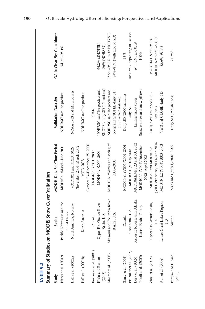
TABLE 9.2
Summary of Studies on MODIS Snow Cover Validation
Study
Region
MODIS Data Set/Time Period
Validation Data Set
OA in Clear Sky Conditions a
Bitner et al. (2002)
Pacific Northwest and the
Great Plains
MOD10A1/March–June 2001
NOHRSC satellite product
94.2%–95.1%
Hall et al. (2002a)
North America, Norway
MOD10C1 and MOD10C2/
November 2001–March 2002
NOAA IMS and MI products
Hall et al. (2002b)
North America
MOD10C2/
October 23–December 25, 2000
NOHRSC satellite product
Bussières et al. (2002)
Canada
MOD10A1/2001–2002
SSM/I
Klein and Barnett
(2003)
Upper Rio Grande River
Basin, U.S.
MOD10A1/2000–2001
NOHRSC satellite product and
SNOTEL daily SD (15 stations)
94.2% (SNOTEL)
86% (NOHSRC)
Maurer et al. (2003)
Missouri and Columbia River
Basins, U.S.
MOD10A1/Winter and spring of
2000–2001
NOHRSC satellite product and
co-op and SNOTEL daily SD
(1330 + 762 stations)
87.5%–95.8% (with NOHRSC)
74%–81% (with ground SD)
Simic et al. (2004)
Canada
MOD10A1 (V003)/2000–2001
Daily SD (2000 stations)
93%
Brubaker et al. (2005)
Continental U.S.
MOD10C1 (V003)/2000
Daily SD
70%–95% depending on season
Déry et al. (2005)
Kuparuk River Basin, Alaska
MOD10A1/May 23 and 30, 2002
Landsat snow cover
R 2
= 0.91 and 0.19
Tekeli et al. (2005)
Karasu Basin, Turkey
MOD10A1 (V004)/December
2002–April 2003
Snow courses and snow pillows
100%
Zhou et al. (2005)
Upper Rio Grande Basin,
U.S.
MOD10A1 and MOD10A2
(V003)/February 2000–June 2004
Daily SWE (four SNOTEL
stations)
MOD10A1: 92%–95.9%
MOD10A2: 89.5%–93.2%
Ault et al. (2006)
Lower Great Lakes Region,
U.S.
MOD10_L2 (V004)/2000–2003
NWS and GLOBE daily SD
85.6%–92.3%
Parajka and Blöschl
(2006)
Austria
MOD10A1(V004)/2000–2005
Daily SD (754 stations)
94.7% b
Multiscale Hydrologic Remote Sensing: Perspectives and Applications
TABLE 9.2
Summary of Studies on MODIS Snow Cover Validation
Study
Region
MODIS Data Set/Time Period
Validation Data Set
OA in Clear Sky Conditions a
Bitner et al. (2002)
Pacific Northwest and the
Great Plains
MOD10A1/March–June 2001
NOHRSC satellite product
94.2%–95.1%
Hall et al. (2002a)
North America, Norway
MOD10C1 and MOD10C2/
November 2001–March 2002
NOAA IMS and MI products
Hall et al. (2002b)
North America
MOD10C2/
October 23–December 25, 2000
NOHRSC satellite product
Bussières et al. (2002)
Canada
MOD10A1/2001–2002
SSM/I
Klein and Barnett
(2003)
Upper Rio Grande River
Basin, U.S.
MOD10A1/2000–2001
NOHRSC satellite product and
SNOTEL daily SD (15 stations)
94.2% (SNOTEL)
86% (NOHSRC)
Maurer et al. (2003)
Missouri and Columbia River
Basins, U.S.
MOD10A1/Winter and spring of
2000–2001
NOHRSC satellite product and
co-op and SNOTEL daily SD
(1330 + 762 stations)
87.5%–95.8% (with NOHRSC)
74%–81% (with ground SD)
Simic et al. (2004)
Canada
MOD10A1 (V003)/2000–2001
Daily SD (2000 stations)
93%
Brubaker et al. (2005)
Continental U.S.
MOD10C1 (V003)/2000
Daily SD
70%–95% depending on season
Déry et al. (2005)
Kuparuk River Basin, Alaska
MOD10A1/May 23 and 30, 2002
Landsat snow cover
R 2
= 0.91 and 0.19
Tekeli et al. (2005)
Karasu Basin, Turkey
MOD10A1 (V004)/December
2002–April 2003
Snow courses and snow pillows
100%
Zhou et al. (2005)
Upper Rio Grande Basin,
U.S.
MOD10A1 and MOD10A2
(V003)/February 2000–June 2004
Daily SWE (four SNOTEL
stations)
MOD10A1: 92%–95.9%
MOD10A2: 89.5%–93.2%
Ault et al. (2006)
Lower Great Lakes Region,
U.S.
MOD10_L2 (V004)/2000–2003
NWS and GLOBE daily SD
85.6%–92.3%
Parajka and Blöschl
(2006)
Austria
MOD10A1(V004)/2000–2005
Daily SD (754 stations)
94.7% b