

171
Modeling Stream Flow Changes
ANNs can be designed to formulate a quantitative linkage between input and output
variables through a numerical approximation of the neural network. Ideally, influential factors can be identified with a semiempirical approach for cases in which physical processes are not fully understood or are highly complex with nonlinear nature.
When influential factors associated with such physical processes cannot be realized
up front, additional methods such as EOF may combine with ANNs to provide synergistic effects in hydrologic system analysis. The case study in the Tarim River Basin,
China, is a response to recent scientific hypothesis stating that the impact of climate
change in this study region has dominated the flow regime since the late 1980s. To
confirm this hypothesis, the main objectives of this study are to (1) extract the spatial
patterns of the precipitation and temperature variance from the Tropical Rainfall
Measuring Mission/Precipitation Radar (TRMM/PR) and the moderate resolution
imaging spectroradiometer (MODIS) land surface temperature (LST) matrix data
using EOF technique and (2) generate a group of input variables for the ANN model
to simulate the stream flow change based on the patterns achieved from the above
EOF analysis, thereby providing some numerical endeavor for hydrologic research
in poorly gauged basins.
8.2 STUDY AREA
The Tarim River Basin is the largest continental river basin in Central Asia. Far
from oceans, the lower Tarim River Basin is often characterized by extremely arid
conditions due to the rain shadow of the surrounding Tienshan, Pamirs, Kunlun,
and Altun mountains. Its annual precipitation varies from 17 to 42 mm, whereas the
annual potential evaporation varies between 2500 and 3000 mm (Hou et al. 2007).
It is considered one of the most environmentally degraded regions in the world (Sun
et al. 2010). Due to stream flow interruption, the lower Tarim River and the Lop Nur
Lake (once the largest lake in the arid region of China) dried up in 1972 and 1970,
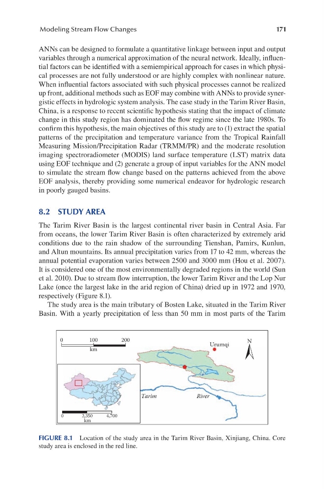
respectively (Figure 8.1).
The study area is the main tributary of Bosten Lake, situated in the Tarim River
Basin. With a yearly precipitation of less than 50 mm in most parts of the Tarim
Urumqi
Tarim
River
0
100
km
km
0
2,350
4,700
200
N
FIGURE 8.1 Location of the study area in the Tarim River Basin, Xinjiang, China. Core
study area is enclosed in the red line.
Modeling Stream Flow Changes
ANNs can be designed to formulate a quantitative linkage between input and output
variables through a numerical approximation of the neural network. Ideally, influential factors can be identified with a semiempirical approach for cases in which physical processes are not fully understood or are highly complex with nonlinear nature.
When influential factors associated with such physical processes cannot be realized
up front, additional methods such as EOF may combine with ANNs to provide synergistic effects in hydrologic system analysis. The case study in the Tarim River Basin,
China, is a response to recent scientific hypothesis stating that the impact of climate
change in this study region has dominated the flow regime since the late 1980s. To
confirm this hypothesis, the main objectives of this study are to (1) extract the spatial
patterns of the precipitation and temperature variance from the Tropical Rainfall
Measuring Mission/Precipitation Radar (TRMM/PR) and the moderate resolution
imaging spectroradiometer (MODIS) land surface temperature (LST) matrix data
using EOF technique and (2) generate a group of input variables for the ANN model
to simulate the stream flow change based on the patterns achieved from the above
EOF analysis, thereby providing some numerical endeavor for hydrologic research
in poorly gauged basins.
8.2 STUDY AREA
The Tarim River Basin is the largest continental river basin in Central Asia. Far
from oceans, the lower Tarim River Basin is often characterized by extremely arid
conditions due to the rain shadow of the surrounding Tienshan, Pamirs, Kunlun,
and Altun mountains. Its annual precipitation varies from 17 to 42 mm, whereas the
annual potential evaporation varies between 2500 and 3000 mm (Hou et al. 2007).
It is considered one of the most environmentally degraded regions in the world (Sun
et al. 2010). Due to stream flow interruption, the lower Tarim River and the Lop Nur
Lake (once the largest lake in the arid region of China) dried up in 1972 and 1970,
respectively (Figure 8.1).
The study area is the main tributary of Bosten Lake, situated in the Tarim River
Basin. With a yearly precipitation of less than 50 mm in most parts of the Tarim
Urumqi
Tarim
River
0
100
km
km
0
2,350
4,700
200
N
FIGURE 8.1 Location of the study area in the Tarim River Basin, Xinjiang, China. Core
study area is enclosed in the red line.