

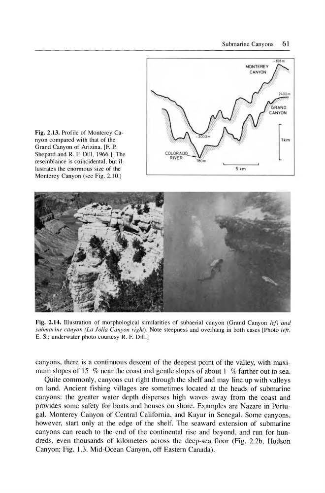
Fig. 2.13. Profile of Monterey Canyon compared with that of the
Grand Canyon of Arizina. [F. P.
Shepard and R. F. Dill, 1966.]. The
resemblance is coincidental, but illustrates the enormous size of the
Monterey Canyon (see Fig. 2.10.)
Submarine Canyons
61
5km
Fig. 2.14. Illustration of morphological similarities of subaerial canyon (Grand Canyon lef) and
submarine canyon (La lolla Canyon right). Note steepness and overhang in both cases [Photo left ,
E. S.; underwater photo courtesy R. F. Dill.]
canyons, there is a continuous descent of the deepest point of the valley, with maximum slopes of 15 % near the coast and gentle slopes of about 1 % farther out to sea.
Quite commonly, canyons cut right through the shelf and may line up with valleys
on land. Ancient fishing vil\ages are sometimes located at the heads of submarine
canyons: the greater water depth disperses high waves away from the coast and
provides some safety for boats and houses on shore. Examples are Nazare in Portugal. Monterey Canyon of Central California, and Kayar in Senegal. Some canyons,
however, start only at the edge of the shelf. The seaward extension of submarine
canyons can reach to the end of the continental rise and beyond, and run for hundreds, even thousands of kilometers across the deep-sea floor (Fig. 2.2b, Hudson
Canyon; Fig. 1.3. Mid-Ocean Canyon, off Eastern Canada).
Grand Canyon of Arizina. [F. P.
Shepard and R. F. Dill, 1966.]. The
resemblance is coincidental, but illustrates the enormous size of the
Monterey Canyon (see Fig. 2.10.)
Submarine Canyons
61
5km
Fig. 2.14. Illustration of morphological similarities of subaerial canyon (Grand Canyon lef) and
submarine canyon (La lolla Canyon right). Note steepness and overhang in both cases [Photo left ,
E. S.; underwater photo courtesy R. F. Dill.]
canyons, there is a continuous descent of the deepest point of the valley, with maximum slopes of 15 % near the coast and gentle slopes of about 1 % farther out to sea.
Quite commonly, canyons cut right through the shelf and may line up with valleys
on land. Ancient fishing vil\ages are sometimes located at the heads of submarine
canyons: the greater water depth disperses high waves away from the coast and
provides some safety for boats and houses on shore. Examples are Nazare in Portugal. Monterey Canyon of Central California, and Kayar in Senegal. Some canyons,
however, start only at the edge of the shelf. The seaward extension of submarine
canyons can reach to the end of the continental rise and beyond, and run for hundreds, even thousands of kilometers across the deep-sea floor (Fig. 2.2b, Hudson
Canyon; Fig. 1.3. Mid-Ocean Canyon, off Eastern Canada).