

54 Origin and Morphology of Ocean Margins
b
DECREASING INTERGRANULAR PERMEABI LITY
INCREASING FRACTURE PERMEABILITY
CHEMICALLY EXOTIC
FLUID FLOWS TO
X : RFACE
HI GH ~~i;aILIT,~;;~:;:,i:l;m~rr;i!i!!ll ! !l l l l l i ! !
DECOL LE MENT
IV
MINERAL DEHYDRATlG.'1 AND
HYDROCI\R130N GENERATION '
"
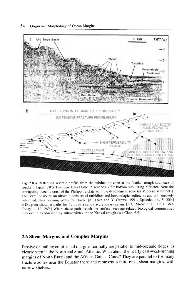
Fig. 2.8 a Reflection seismic profile from the subduction zone at the Nankai trough southeast of
southern Japan. 7WS Two-way travel time in seconds; BSR bottom simulating reflector. Note the
downgoing oceanic crust of the Philippine plate with the decollement zone (in Miocene sediments) .
The accretionary prism above it consists of turbidites and hemipelagic sediments and is intensively
deformed, thus opening paths for fluids . [A. Taira and Y. Ogawa, 1991 , Episodes 14, 3: 209.]
b Diagram showing paths for fluids in a sandy accretionary pri sm. [J. C. Moore et aI., 199 I, GSA
Today, I, 12: 269.] Where these paths reach the surface, seepage-related biological communities
may occur, as obse rved by submersibles in the Nankai trough (see Chap. 6.9).
2.6 Shear Margins and Complex Margins
Passive or trailing continental margins normally are parallel to mid-oceanic ridges , as
clearly seen in the North and South Atlantic. What about the nearly east-west-running
margins of North Brazil and the African Guinea Coast? They are parallel to the many
fracture zones near the Equator there and represent a third type, shear margins, with
narrow shelves.
b
DECREASING INTERGRANULAR PERMEABI LITY
INCREASING FRACTURE PERMEABILITY
CHEMICALLY EXOTIC
FLUID FLOWS TO
X : RFACE
HI GH ~~i;aILIT,~;;~:;:,i:l;m~rr;i!i!!ll ! !l l l l l i ! !
DECOL LE MENT
IV
MINERAL DEHYDRATlG.'1 AND
HYDROCI\R130N GENERATION '
"
Fig. 2.8 a Reflection seismic profile from the subduction zone at the Nankai trough southeast of
southern Japan. 7WS Two-way travel time in seconds; BSR bottom simulating reflector. Note the
downgoing oceanic crust of the Philippine plate with the decollement zone (in Miocene sediments) .
The accretionary prism above it consists of turbidites and hemipelagic sediments and is intensively
deformed, thus opening paths for fluids . [A. Taira and Y. Ogawa, 1991 , Episodes 14, 3: 209.]
b Diagram showing paths for fluids in a sandy accretionary pri sm. [J. C. Moore et aI., 199 I, GSA
Today, I, 12: 269.] Where these paths reach the surface, seepage-related biological communities
may occur, as obse rved by submersibles in the Nankai trough (see Chap. 6.9).
2.6 Shear Margins and Complex Margins
Passive or trailing continental margins normally are parallel to mid-oceanic ridges , as
clearly seen in the North and South Atlantic. What about the nearly east-west-running
margins of North Brazil and the African Guinea Coast? They are parallel to the many
fracture zones near the Equator there and represent a third type, shear margins, with
narrow shelves.