

Endogenic Processes
17
The exact nature of the forces and motions deep within the Earth is not accessible
to direct observation by sampling. Even the deepest drill holes (down to 12 km) only
scratch the surface of the Earth. They do not penetrate the crust, which is defined as
the uppermost layer of the solid Earth. Continental crust is about 20 to 50 km thick,
while oceanic crust is much thinner, 5-10 km. The mantle below the crust is the
source of the endogenic forces working on the crust. It is 2850 km thick and makes
a r---------------------------~
4000 - --U-------4--- ~--r_----+_~~
I
2
3
4
S
6
Km
Continental
-
Slope
-
c Rise
Channel
ABYSSAL PLAIN
MID -OC EANIC RIDGE
Seamount
ABYSSAL
HILLS
Flank
Rift Valley
Cr est
Fl ank
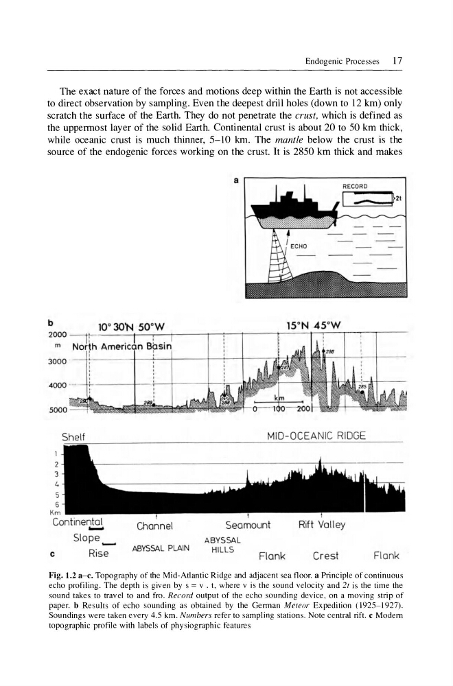
Fig. 1.2 a- c. Topography of the Mid-Atlantic Ridge and adjacent sea floor. a Principle of continuous
echo profiling. The depth is given by s = v . t, where v is the sound velocity and 2t is the time the
sound takes to travel to and fro. Record output of the echo sounding device , on a moving strip of
paper. b Results of echo sounding as obtained by the German Meteor Expedition (1925- 1927).
Soundings were taken every 4.5 km. Numhers refer to sampling stations. Note central rift. c Modem
topographic profile with labels of physiographic features
17
The exact nature of the forces and motions deep within the Earth is not accessible
to direct observation by sampling. Even the deepest drill holes (down to 12 km) only
scratch the surface of the Earth. They do not penetrate the crust, which is defined as
the uppermost layer of the solid Earth. Continental crust is about 20 to 50 km thick,
while oceanic crust is much thinner, 5-10 km. The mantle below the crust is the
source of the endogenic forces working on the crust. It is 2850 km thick and makes
a r---------------------------~
4000 - --U-------4--- ~--r_----+_~~
I
2
3
4
S
6
Km
Continental
-
Slope
-
c Rise
Channel
ABYSSAL PLAIN
MID -OC EANIC RIDGE
Seamount
ABYSSAL
HILLS
Flank
Rift Valley
Cr est
Fl ank
Fig. 1.2 a- c. Topography of the Mid-Atlantic Ridge and adjacent sea floor. a Principle of continuous
echo profiling. The depth is given by s = v . t, where v is the sound velocity and 2t is the time the
sound takes to travel to and fro. Record output of the echo sounding device , on a moving strip of
paper. b Results of echo sounding as obtained by the German Meteor Expedition (1925- 1927).
Soundings were taken every 4.5 km. Numhers refer to sampling stations. Note central rift. c Modem
topographic profile with labels of physiographic features