

258
11.4
C. Simmer
Signal of precipitation in remote sensing measurements
According to the dominant interaction processes between electromagnetic radiation and the
raining cloud, we can distinguish four types of signals predominantly observed in four frequency ranges of the electromagnetic spectrum. The first three signal types are the basis of
passive techniques in the three spectral ranges of the electromagnetic spectrum with atmospheric windows, namely the visible/infrared, the high-frequency microwaves (v > 50 GHz),
and the middle-frequency microwaves (10 GHz < v < 50 GHz). A schematic description of
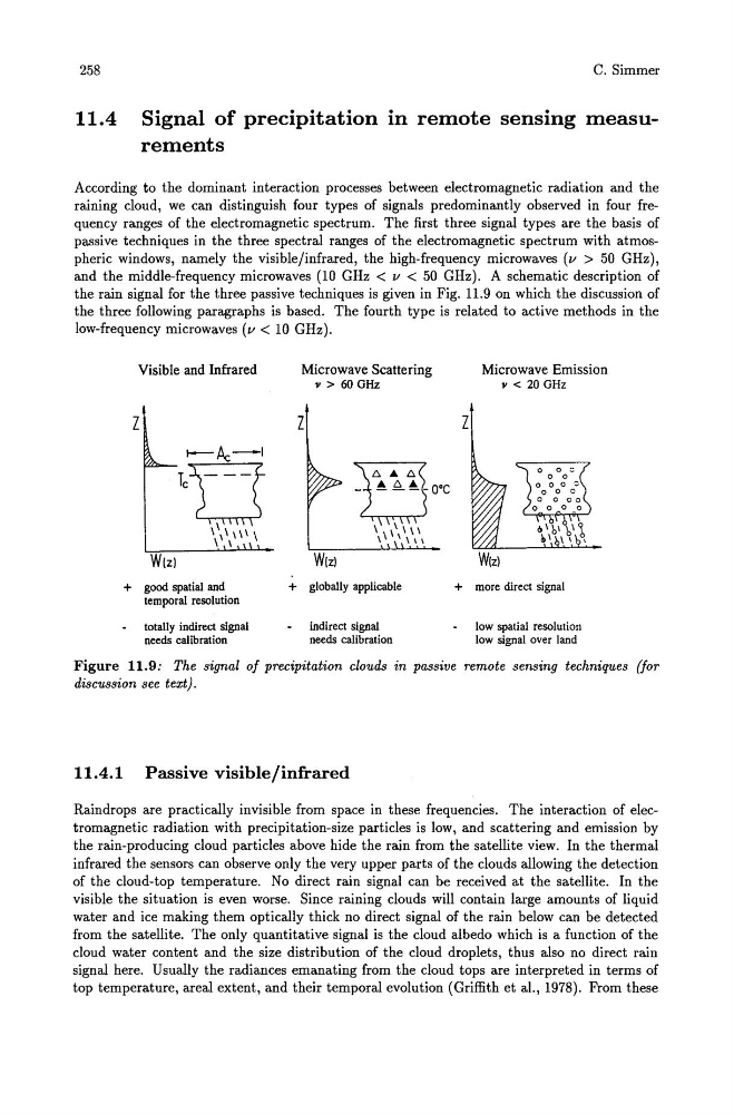
the rain signal for the three passive techniques is given in Fig. 11.9 on which the discussion of
the three following paragraphs is based. The fourth type is related to active methods in the
low-frequency microwaves (v < 10 GHz).
Visible and Infrared
Microwave Scattering
Microwave Emission
" > 60 GHz
" < 20 GHz
Z
Z
Z
t----A:.-I
'u 0
- ~ ~~-O·C
1\111 1 \
11 1"111
\ I
I
I \ \
W(z)
W(z)
+ good spatial and
+ globally applicable
+ more direct signal
temporal resolution
totally indirect signal
indirect signal
low spatial resolution
needs calibration
needs calibration
low signal over land
Figure 11.9: The signal of precipitation clouds in passive remote sensing techniques (for
discussion see text).
11.4.1 Passive visible/infrared
Raindrops are practically invisible from space in these frequencies. The interaction of electromagnetic radiation with precipitation-size particles is low, and scattering and emission by
the rain-producing cloud particles above hide the rain from the satellite view. In the thermal
infrared the sensors can observe only the very upper parts of the clouds allowing the detection
of the cloud-top temperature. No direct rain signal can be received at the satellite. In the
visible the situation is even worse. Since raining clouds will contain large amounts of liquid
water and ice making them optically thick no direct signal of the rain below can be detected
from the satellite. The only quantitative signal is the cloud albedo which is a function of the
cloud water content and the size distribution of the cloud droplets, thus also no direct rain
signal here. Usually the radiances emanating from the cloud tops are interpreted in terms of
top temperature, areal extent, and their temporal evolution (Griffith et aI., 1978). From these
11.4
C. Simmer
Signal of precipitation in remote sensing measurements
According to the dominant interaction processes between electromagnetic radiation and the
raining cloud, we can distinguish four types of signals predominantly observed in four frequency ranges of the electromagnetic spectrum. The first three signal types are the basis of
passive techniques in the three spectral ranges of the electromagnetic spectrum with atmospheric windows, namely the visible/infrared, the high-frequency microwaves (v > 50 GHz),
and the middle-frequency microwaves (10 GHz < v < 50 GHz). A schematic description of
the rain signal for the three passive techniques is given in Fig. 11.9 on which the discussion of
the three following paragraphs is based. The fourth type is related to active methods in the
low-frequency microwaves (v < 10 GHz).
Visible and Infrared
Microwave Scattering
Microwave Emission
" > 60 GHz
" < 20 GHz
Z
Z
Z
t----A:.-I
'u 0
- ~ ~~-O·C
1\111 1 \
11 1"111
\ I
I
I \ \
W(z)
W(z)
+ good spatial and
+ globally applicable
+ more direct signal
temporal resolution
totally indirect signal
indirect signal
low spatial resolution
needs calibration
needs calibration
low signal over land
Figure 11.9: The signal of precipitation clouds in passive remote sensing techniques (for
discussion see text).
11.4.1 Passive visible/infrared
Raindrops are practically invisible from space in these frequencies. The interaction of electromagnetic radiation with precipitation-size particles is low, and scattering and emission by
the rain-producing cloud particles above hide the rain from the satellite view. In the thermal
infrared the sensors can observe only the very upper parts of the clouds allowing the detection
of the cloud-top temperature. No direct rain signal can be received at the satellite. In the
visible the situation is even worse. Since raining clouds will contain large amounts of liquid
water and ice making them optically thick no direct signal of the rain below can be detected
from the satellite. The only quantitative signal is the cloud albedo which is a function of the
cloud water content and the size distribution of the cloud droplets, thus also no direct rain
signal here. Usually the radiances emanating from the cloud tops are interpreted in terms of
top temperature, areal extent, and their temporal evolution (Griffith et aI., 1978). From these