

sin θ ¼
Satellite Altitude þ Earth Radius
Earth Radius
sin θ v
% 6:37 sin θ v
ð19:57Þ
Therefore, the maximum satellite viewing angle (about 8.7
) corresponds to
74.48
of view zenith angle. Such a large view zenith angle may have great impact
on LST retrieval since, for instance, when the zenith angle is increased from 0
to
60
, the atmospheric path length is doubled. As shown in Figs. 19.9, 19.10, 19.11,
19.12, and 19.13, we can see the algorithm error distributions with satellite zenith
angle indicate, for the moist atmospheric conditions, the errors become significantly
worse when the viewing zenith angle is larger than 6 or satellite zenith angle (SZA)
is larger than 42
. For dry atmospheric conditions, the LST errors are less sensitive
to viewing geometry.
Two other important error sources in LST retrieval are the surface emissivity
uncertainty and the atmospheric water vapor absorption.
19.5.4.2 Water Vapor Uncertainty
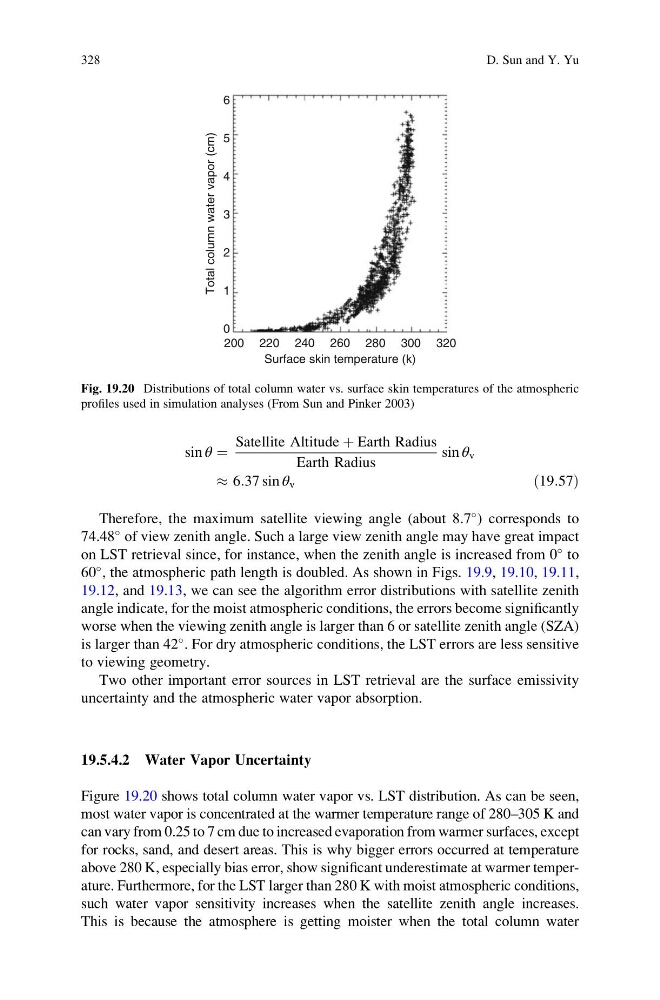
Figure 19.20 shows total column water vapor vs. LST distribution. As can be seen,
most water vapor is concentrated at the warmer temperature range of 280–305 K and
can vary from 0.25 to 7 cm due to increased evaporation from warmer surfaces, except
for rocks, sand, and desert areas. This is why bigger errors occurred at temperature
above 280 K, especially bias error, show significant underestimate at warmer temperature. Furthermore, for the LST larger than 280 K with moist atmospheric conditions,
such water vapor sensitivity increases when the satellite zenith angle increases.
This is because the atmosphere is getting moister when the total column water
6
5
4
3
Total column water vapor (cm)
2
1
0
200 220 240 260 280
Surface skin temperature (k)
300 320
Fig. 19.20 Distributions of total column water vs. surface skin temperatures of the atmospheric
profiles used in simulation analyses (From Sun and Pinker 2003)
328
D. Sun and Y. Yu
Satellite Altitude þ Earth Radius
Earth Radius
sin θ v
% 6:37 sin θ v
ð19:57Þ
Therefore, the maximum satellite viewing angle (about 8.7
) corresponds to
74.48
of view zenith angle. Such a large view zenith angle may have great impact
on LST retrieval since, for instance, when the zenith angle is increased from 0
to
60
, the atmospheric path length is doubled. As shown in Figs. 19.9, 19.10, 19.11,
19.12, and 19.13, we can see the algorithm error distributions with satellite zenith
angle indicate, for the moist atmospheric conditions, the errors become significantly
worse when the viewing zenith angle is larger than 6 or satellite zenith angle (SZA)
is larger than 42
. For dry atmospheric conditions, the LST errors are less sensitive
to viewing geometry.
Two other important error sources in LST retrieval are the surface emissivity
uncertainty and the atmospheric water vapor absorption.
19.5.4.2 Water Vapor Uncertainty
Figure 19.20 shows total column water vapor vs. LST distribution. As can be seen,
most water vapor is concentrated at the warmer temperature range of 280–305 K and
can vary from 0.25 to 7 cm due to increased evaporation from warmer surfaces, except
for rocks, sand, and desert areas. This is why bigger errors occurred at temperature
above 280 K, especially bias error, show significant underestimate at warmer temperature. Furthermore, for the LST larger than 280 K with moist atmospheric conditions,
such water vapor sensitivity increases when the satellite zenith angle increases.
This is because the atmosphere is getting moister when the total column water
6
5
4
3
Total column water vapor (cm)
2
1
0
200 220 240 260 280
Surface skin temperature (k)
300 320
Fig. 19.20 Distributions of total column water vs. surface skin temperatures of the atmospheric
profiles used in simulation analyses (From Sun and Pinker 2003)
328
D. Sun and Y. Yu