

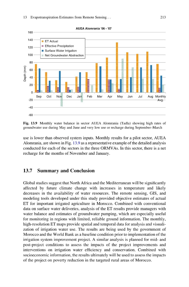
use is lower than observed system inputs. Monthly results for a pilot sector, AUEA
Alomrania, are shown in Fig. 13.9 as a representative example of the detailed analysis
conducted for each of the sectors in the three ORMVAs. In this sector, there is a net
recharge for the months of November and January.
13.7 Summary and Conclusion
Global studies suggest that North Africa and the Mediterranean will be significantly
affected by future climate change with increases in temperature and likely
decreases in the availability of water resources. The remote sensing, GIS, and
modeling tools developed under this study provided objective estimates of actual
ET for important irrigated agriculture in Morocco. Combined with conventional
data on surface water deliveries, analysis of the ET results provide managers with
water balance and estimates of groundwater pumping, which are especially useful
for monitoring in regions with limited, reliable ground information. The monthly,
high-resolution ET maps provide spatial and temporal data for analysis and visualization of irrigation water use. The results are being used by the government of
Morocco and the World Bank as a baseline condition prior to implementation of the
irrigation system improvement project. A similar analysis is planned for mid- and
post-project conditions to assess the impacts of the project improvements and
interventions on irrigation water efficiency and conservation. Combined with
socioeconomic information, the results ultimately will be used to assess the impacts
of the project on poverty reduction in the targeted rural areas of Morocco.
AUEA Alomrania '06 - '07
-60
-40
-20
0
20
40
60
80
100
120
140
160
Sep
Oct
Nov
Dec
Jan
Feb
Mar
Apr
May
Jun
Jul
Aug Monthly
Avg.
Depth (mm)
ET Actual
Effective Precipitation
Surface Water Irrigation
Net Groundwater Abstraction
Fig. 13.9 Monthly water balance in sector AUEA Alomrania (Tadla) showing high rates of
groundwater use during May and June and very low use or recharge during September–March
13 Evapotranspiration Estimates from Remote Sensing. . .
213
Alomrania, are shown in Fig. 13.9 as a representative example of the detailed analysis
conducted for each of the sectors in the three ORMVAs. In this sector, there is a net
recharge for the months of November and January.
13.7 Summary and Conclusion
Global studies suggest that North Africa and the Mediterranean will be significantly
affected by future climate change with increases in temperature and likely
decreases in the availability of water resources. The remote sensing, GIS, and
modeling tools developed under this study provided objective estimates of actual
ET for important irrigated agriculture in Morocco. Combined with conventional
data on surface water deliveries, analysis of the ET results provide managers with
water balance and estimates of groundwater pumping, which are especially useful
for monitoring in regions with limited, reliable ground information. The monthly,
high-resolution ET maps provide spatial and temporal data for analysis and visualization of irrigation water use. The results are being used by the government of
Morocco and the World Bank as a baseline condition prior to implementation of the
irrigation system improvement project. A similar analysis is planned for mid- and
post-project conditions to assess the impacts of the project improvements and
interventions on irrigation water efficiency and conservation. Combined with
socioeconomic information, the results ultimately will be used to assess the impacts
of the project on poverty reduction in the targeted rural areas of Morocco.
AUEA Alomrania '06 - '07
-60
-40
-20
0
20
40
60
80
100
120
140
160
Sep
Oct
Nov
Dec
Jan
Feb
Mar
Apr
May
Jun
Jul
Aug Monthly
Avg.
Depth (mm)
ET Actual
Effective Precipitation
Surface Water Irrigation
Net Groundwater Abstraction
Fig. 13.9 Monthly water balance in sector AUEA Alomrania (Tadla) showing high rates of
groundwater use during May and June and very low use or recharge during September–March
13 Evapotranspiration Estimates from Remote Sensing. . .
213