

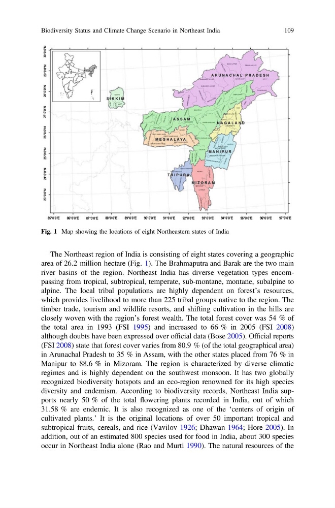
The Northeast region of India is consisting of eight states covering a geographic
area of 26.2 million hectare (Fig. 1). The Brahmaputra and Barak are the two main
river basins of the region. Northeast India has diverse vegetation types encompassing from tropical, subtropical, temperate, sub-montane, montane, subalpine to
alpine. The local tribal populations are highly dependent on forest’s resources,
which provides livelihood to more than 225 tribal groups native to the region. The
timber trade, tourism and wildlife resorts, and shifting cultivation in the hills are
closely woven with the region’s forest wealth. The total forest cover was 54 % of
the total area in 1993 (FSI 1995) and increased to 66 % in 2005 (FSI 2008)
although doubts have been expressed over official data (Bose 2005). Official reports
(FSI 2008) state that forest cover varies from 80.9 % (of the total geographical area)
in Arunachal Pradesh to 35 % in Assam, with the other states placed from 76 % in
Manipur to 88.6 % in Mizoram. The region is characterized by diverse climatic
regimes and is highly dependent on the southwest monsoon. It has two globally
recognized biodiversity hotspots and an eco-region renowned for its high species
diversity and endemism. According to biodiversity records, Northeast India supports nearly 50 % of the total flowering plants recorded in India, out of which
31.58 % are endemic. It is also recognized as one of the ‘centers of origin of
cultivated plants.’ It is the original locations of over 50 important tropical and
subtropical fruits, cereals, and rice (Vavilov 1926; Dhawan 1964; Hore 2005). In
addition, out of an estimated 800 species used for food in India, about 300 species
occur in Northeast India alone (Rao and Murti 1990). The natural resources of the
Fig. 1 Map showing the locations of eight Northeastern states of India
Biodiversity Status and Climate Change Scenario in Northeast India
109
area of 26.2 million hectare (Fig. 1). The Brahmaputra and Barak are the two main
river basins of the region. Northeast India has diverse vegetation types encompassing from tropical, subtropical, temperate, sub-montane, montane, subalpine to
alpine. The local tribal populations are highly dependent on forest’s resources,
which provides livelihood to more than 225 tribal groups native to the region. The
timber trade, tourism and wildlife resorts, and shifting cultivation in the hills are
closely woven with the region’s forest wealth. The total forest cover was 54 % of
the total area in 1993 (FSI 1995) and increased to 66 % in 2005 (FSI 2008)
although doubts have been expressed over official data (Bose 2005). Official reports
(FSI 2008) state that forest cover varies from 80.9 % (of the total geographical area)
in Arunachal Pradesh to 35 % in Assam, with the other states placed from 76 % in
Manipur to 88.6 % in Mizoram. The region is characterized by diverse climatic
regimes and is highly dependent on the southwest monsoon. It has two globally
recognized biodiversity hotspots and an eco-region renowned for its high species
diversity and endemism. According to biodiversity records, Northeast India supports nearly 50 % of the total flowering plants recorded in India, out of which
31.58 % are endemic. It is also recognized as one of the ‘centers of origin of
cultivated plants.’ It is the original locations of over 50 important tropical and
subtropical fruits, cereals, and rice (Vavilov 1926; Dhawan 1964; Hore 2005). In
addition, out of an estimated 800 species used for food in India, about 300 species
occur in Northeast India alone (Rao and Murti 1990). The natural resources of the
Fig. 1 Map showing the locations of eight Northeastern states of India
Biodiversity Status and Climate Change Scenario in Northeast India
109