

54
Spatial and
temporal
p,..,lplt3tlon
panem
RLUt-off to Sed
.
. ..
H.-J. Bolle
SCllil1 i:!:crt Ion of ground wdlel In COilS tal zones
. ...
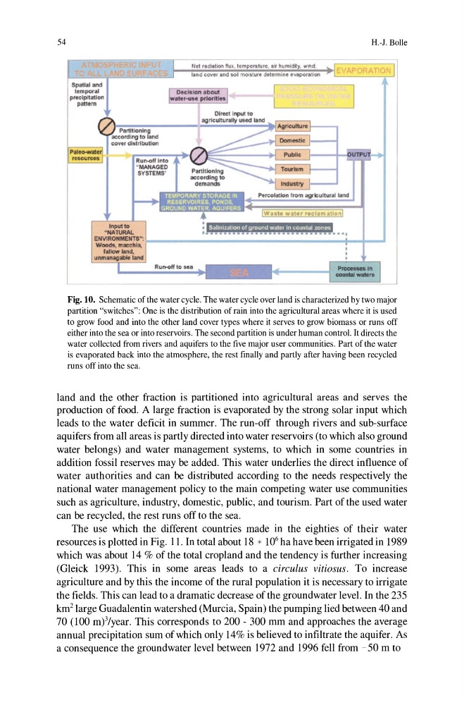
Fig. 10. Schematic of the water cycle. The water cycle over land is characterized by two major
partition "switches": One is the distribution of rain into the agricultural areas where it is used
to grow food and into the other land cover types where it serves to grow biomass or runs off
either into the sea or into reservoirs. The second partition is under human control. It directs the
water collected from rivers and aquifers to the five major user communities. Part of the water
is evaporated back into the atmosphere, the rest finally and partly after having been recycled
runs off into the sea.
land and the other fraction is partitioned into agricultural areas and serves the
production of food. A large fraction is evaporated by the strong solar input which
leads to the water deficit in summer. The run-off through rivers and sub-surface
aquifers from all areas is partly directed into water reservoirs (to which also ground
water belongs) and water management systems, to which in some countries in
addition fossil reserves may be added. This water underlies the direct influence of
water authorities and can be distributed according to the needs respectively the
national water management policy to the main competing water use communities
such as agriculture, industry, domestic, public, and tourism. Part of the used water
can be recycled, the rest runs off to the sea.
The use which the different countries made in the eighties of their water
resources is plotted in Fig. 11. In total about 18 * 10 6 ha have been irrigated in 1989
which was about 14 % of the total cropland and the tendency is further increasing
(Gleick 1993). This in some areas leads to a circulus vitiosus. To increase
agriculture and by this the income of the rural population it is necessary to irrigate
the fields. This can lead to a dramatic decrease of the groundwater level. In the 235
km 2 large Guadalentin watershed (Murcia, Spain) the pumping lied between 40 and
70 (100 m)3/year. This corresponds to 200 - 300 mm and approaches the average
annual precipitation sum of which only 14% is believed to infiltrate the aquifer. As
a consequence the groundwater level between 1972 and 1996 fell from - 50 m to
Spatial and
temporal
p,..,lplt3tlon
panem
RLUt-off to Sed
.
. ..
H.-J. Bolle
SCllil1 i:!:crt Ion of ground wdlel In COilS tal zones
. ...
Fig. 10. Schematic of the water cycle. The water cycle over land is characterized by two major
partition "switches": One is the distribution of rain into the agricultural areas where it is used
to grow food and into the other land cover types where it serves to grow biomass or runs off
either into the sea or into reservoirs. The second partition is under human control. It directs the
water collected from rivers and aquifers to the five major user communities. Part of the water
is evaporated back into the atmosphere, the rest finally and partly after having been recycled
runs off into the sea.
land and the other fraction is partitioned into agricultural areas and serves the
production of food. A large fraction is evaporated by the strong solar input which
leads to the water deficit in summer. The run-off through rivers and sub-surface
aquifers from all areas is partly directed into water reservoirs (to which also ground
water belongs) and water management systems, to which in some countries in
addition fossil reserves may be added. This water underlies the direct influence of
water authorities and can be distributed according to the needs respectively the
national water management policy to the main competing water use communities
such as agriculture, industry, domestic, public, and tourism. Part of the used water
can be recycled, the rest runs off to the sea.
The use which the different countries made in the eighties of their water
resources is plotted in Fig. 11. In total about 18 * 10 6 ha have been irrigated in 1989
which was about 14 % of the total cropland and the tendency is further increasing
(Gleick 1993). This in some areas leads to a circulus vitiosus. To increase
agriculture and by this the income of the rural population it is necessary to irrigate
the fields. This can lead to a dramatic decrease of the groundwater level. In the 235
km 2 large Guadalentin watershed (Murcia, Spain) the pumping lied between 40 and
70 (100 m)3/year. This corresponds to 200 - 300 mm and approaches the average
annual precipitation sum of which only 14% is believed to infiltrate the aquifer. As
a consequence the groundwater level between 1972 and 1996 fell from - 50 m to