

32
H.-J. Bolle
scale to an area of 10 4 km 2 and from sub-surface water transports to the free
troposphere. In order to cover such an large area three sites typical for the mixture
of land cover in that area were selected which form a triangle of 70 km side length.
At the centre of each of these sites heavily instrumented central stations were
established and surrounded by simpler equipment at distances up to five kilometres
to assess local inhomogeneities.
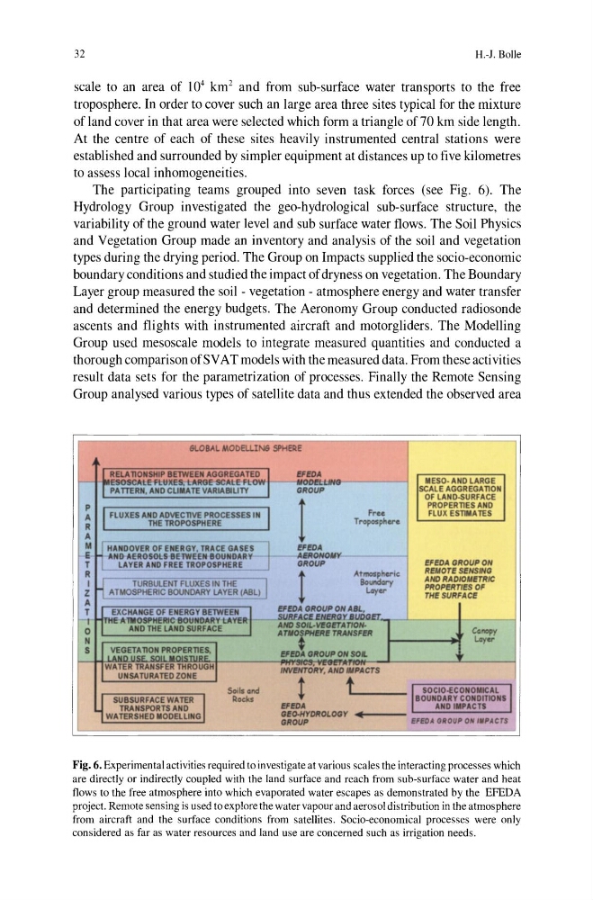
The participating teams grouped into seven task forces (see Fig. 6). The
Hydrology Group investigated the geo-hydrological sub-surface structure, the
variability of the ground water level and sub surface water flows. The Soil Physics
and Vegetation Group made an inventory and analysis of the soil and vegetation
types during the drying period. The Group on Impacts supplied the socio-economic
boundary conditions and studied the impact of dryness on vegetation. The Boundary
Layer group measured the soil - vegetation - atmosphere energy and water transfer
and determined the energy budgets. The Aeronomy Group conducted radiosonde
ascents and flights with instrumented aircraft and motorgliders. The Modelling
Group used mesoscale models to integrate measured quantities and conducted a
thorough comparison ofSV AT models with the measured data. From these activities
result data sets for the parametrization of processes. Finally the Remote Sensing
Group analysed various types of satellite data and thus extended the observed area
6LOBAL MOOEUIN6 SPHERE
RELA TlONSHIP BETWEEN AGGREGATED ~I
es&SeAt£Tt.ItlI.€S;tAfIG€-SCAlE-Fl owPA TTEAN, AND ClIlIATE VARIABI LI TY
P
A
FLUXES AND ADVECTlVE PROCESSES IN I
R
THE TROPOSPHERE
A
M I fHANDOVER OF ENERGY, TRAC E GASES ~
E fJ AHO AEROSOL&8ElWEEN BOUNOARY
T
LAYER AND FREE TROPOSPHERE
R
I H TURBULENT FlUXES IN THe--'1
Z
ATMOSPHERIC BOUNDARY LAYER CASL)
A
!FfDA
GROUP
I
EFEDA
AERONOMY
GROUP
t
Free
TrOf<>Sphere
-.
Atmosplluic
BoundGry
lAyer
EFEDA GROUP ON AIL,
II ESO- AND LARGE
SCALE AGGREGATlON
OF LA ND-SURFACE
PROPERTlES AND
FlUX ESlIMA TES
EFEDA GROUP ON
REMOT! S!NSING
ANO RAOIOMETRIC
PROPERTIES OF
r H!SURFACE
II
T rr~EXCHANGE OF ENERGY BETWEEN t , .
)
E AlIIOSI'tfERIC BOUNDARY LAYER
o
ANO THE LAND SURFACE
~':::;'f_=JrAg:GEI .. _ L.-_ _ _ - - - --I
A TIIO~PH!RE TRANSFER
Co oopy
H
S
WATER TRANSfER THROUGH
UNSATlJRATED ZONE
SUBSURFACE WATER ; I
TRANSPORTS ANO
WATERSHED IIODEL UNG
SoIl • • nd
Rocks
;
lAyer
!FfDA GROUP ON SOl.
INVENTORY. ANO MlPACTS
t t
I SOCIO-ECONOIlICAL I
L.____ BOUNOARY CONOITIONS
!FfDA
ANDIII'ACTS
G!o.HYOROLOGY .... 1--_ _ L----""""'-;;;';;";";';';'''----'
GROUP
EFEOA GROUP O ~ III PACTS
Fig. 6. Experimental activities required to investigate at various scales the interacting processes which
are directly or indirectly coupled with the land surface and reach from sub-surface water and heat
flows to the free atmosphere into which evaporated water escapes as demonstrated by the EFEDA
project. Remote sensing is used to explore the water vapour and aerosol distribution in the atmosphere
from aircraft and the surface conditions from satellites. Socio-economical processes were only
considered as far as water resources and land use are concerned such as irrigation needs.
H.-J. Bolle
scale to an area of 10 4 km 2 and from sub-surface water transports to the free
troposphere. In order to cover such an large area three sites typical for the mixture
of land cover in that area were selected which form a triangle of 70 km side length.
At the centre of each of these sites heavily instrumented central stations were
established and surrounded by simpler equipment at distances up to five kilometres
to assess local inhomogeneities.
The participating teams grouped into seven task forces (see Fig. 6). The
Hydrology Group investigated the geo-hydrological sub-surface structure, the
variability of the ground water level and sub surface water flows. The Soil Physics
and Vegetation Group made an inventory and analysis of the soil and vegetation
types during the drying period. The Group on Impacts supplied the socio-economic
boundary conditions and studied the impact of dryness on vegetation. The Boundary
Layer group measured the soil - vegetation - atmosphere energy and water transfer
and determined the energy budgets. The Aeronomy Group conducted radiosonde
ascents and flights with instrumented aircraft and motorgliders. The Modelling
Group used mesoscale models to integrate measured quantities and conducted a
thorough comparison ofSV AT models with the measured data. From these activities
result data sets for the parametrization of processes. Finally the Remote Sensing
Group analysed various types of satellite data and thus extended the observed area
6LOBAL MOOEUIN6 SPHERE
RELA TlONSHIP BETWEEN AGGREGATED ~I
es&SeAt£Tt.ItlI.€S;tAfIG€-SCAlE-Fl owPA TTEAN, AND ClIlIATE VARIABI LI TY
P
A
FLUXES AND ADVECTlVE PROCESSES IN I
R
THE TROPOSPHERE
A
M I fHANDOVER OF ENERGY, TRAC E GASES ~
E fJ AHO AEROSOL&8ElWEEN BOUNOARY
T
LAYER AND FREE TROPOSPHERE
R
I H TURBULENT FlUXES IN THe--'1
Z
ATMOSPHERIC BOUNDARY LAYER CASL)
A
!FfDA
GROUP
I
EFEDA
AERONOMY
GROUP
t
Free
TrOf<>Sphere
-.
Atmosplluic
BoundGry
lAyer
EFEDA GROUP ON AIL,
II ESO- AND LARGE
SCALE AGGREGATlON
OF LA ND-SURFACE
PROPERTlES AND
FlUX ESlIMA TES
EFEDA GROUP ON
REMOT! S!NSING
ANO RAOIOMETRIC
PROPERTIES OF
r H!SURFACE
II
T rr~EXCHANGE OF ENERGY BETWEEN t , .
)
E AlIIOSI'tfERIC BOUNDARY LAYER
o
ANO THE LAND SURFACE
~':::;'f_=JrAg:GEI .. _ L.-_ _ _ - - - --I
A TIIO~PH!RE TRANSFER
Co oopy
H
S
WATER TRANSfER THROUGH
UNSATlJRATED ZONE
SUBSURFACE WATER ; I
TRANSPORTS ANO
WATERSHED IIODEL UNG
SoIl • • nd
Rocks
;
lAyer
!FfDA GROUP ON SOl.
INVENTORY. ANO MlPACTS
t t
I SOCIO-ECONOIlICAL I
L.____ BOUNOARY CONOITIONS
!FfDA
ANDIII'ACTS
G!o.HYOROLOGY .... 1--_ _ L----""""'-;;;';;";";';';'''----'
GROUP
EFEOA GROUP O ~ III PACTS
Fig. 6. Experimental activities required to investigate at various scales the interacting processes which
are directly or indirectly coupled with the land surface and reach from sub-surface water and heat
flows to the free atmosphere into which evaporated water escapes as demonstrated by the EFEDA
project. Remote sensing is used to explore the water vapour and aerosol distribution in the atmosphere
from aircraft and the surface conditions from satellites. Socio-economical processes were only
considered as far as water resources and land use are concerned such as irrigation needs.