

Osmar O. Moller Jr .. Patrice Castaing
o
I
:
S2'W
,
,
I
Porto Aleg re
I
",..,.~
,
,
I
,
,
,
,,I
I
SOkm
Sl'W
I
I
I
I
,
,
/
,,/'~~
I
I
,
,
/
30' S
31 ' S
32' S
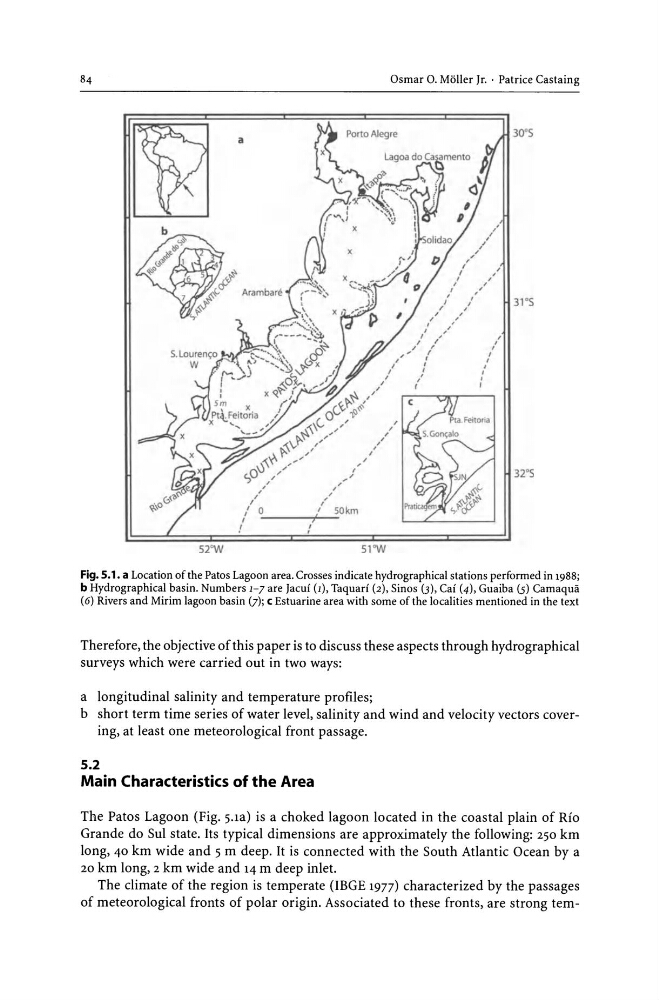
Fig. 5.1. a Location of the Patos Lagoon area. Crosses indicate hydrographical stations performed in 1988;
b Hydrographical basin. Numbers 1-7 are Jacuf (1), Taquarf (2), Sinos (3), Caf (4), Guaiba (5) Cam aqua
(6) Rivers and Mirim lagoon basin (J); c Estuarine area with some of the localities mentioned in the text
Therefore, the objective of this paper is to discuss these aspects through hydrographical
surveys which were carried out in two ways:
a longitudinal salinity and temperature profiles;
b short term time series of water level, salinity and wind and velocity vectors covering, at least one meteorological front passage.
5.2
Main Characteristics of the Area
The Patos Lagoon (Fig. 5.1a) is a choked lagoon located in the coastal plain of Rio
Grande do SuI state. Its typical dimensions are approximately the following: 250 km
long, 40 km wide and 5 m deep. It is connected with the South Atlantic Ocean by a
20 km long, 2 km wide and 14 m deep inlet.
The climate of the region is temperate (lEGE 1977) characterized by the passages
of meteorological fronts of polar origin. Associated to these fronts, are strong tem-
o
I
:
S2'W
,
,
I
Porto Aleg re
I
",..,.~
,
,
I
,
,
,
,,I
I
SOkm
Sl'W
I
I
I
I
,
,
/
,,/'~~
I
I
,
,
/
30' S
31 ' S
32' S
Fig. 5.1. a Location of the Patos Lagoon area. Crosses indicate hydrographical stations performed in 1988;
b Hydrographical basin. Numbers 1-7 are Jacuf (1), Taquarf (2), Sinos (3), Caf (4), Guaiba (5) Cam aqua
(6) Rivers and Mirim lagoon basin (J); c Estuarine area with some of the localities mentioned in the text
Therefore, the objective of this paper is to discuss these aspects through hydrographical
surveys which were carried out in two ways:
a longitudinal salinity and temperature profiles;
b short term time series of water level, salinity and wind and velocity vectors covering, at least one meteorological front passage.
5.2
Main Characteristics of the Area
The Patos Lagoon (Fig. 5.1a) is a choked lagoon located in the coastal plain of Rio
Grande do SuI state. Its typical dimensions are approximately the following: 250 km
long, 40 km wide and 5 m deep. It is connected with the South Atlantic Ocean by a
20 km long, 2 km wide and 14 m deep inlet.
The climate of the region is temperate (lEGE 1977) characterized by the passages
of meteorological fronts of polar origin. Associated to these fronts, are strong tem-