

202
Gerardo M.E. Perillo . M. Cintia Piccolo
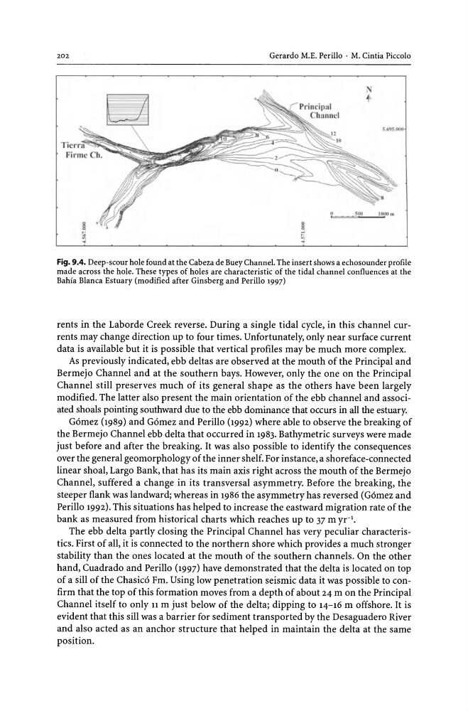
Fig. 9.4. Deep-scour hole found at the Cabeza de Buey Channel. The insert shows a echosounder profile
made across the hole. These types of holes are characteristic of the tidal channel confluences at the
Bahia Blanca Estuary (modified after Ginsberg and Perillo 1997)
rents in the Laborde Creek reverse. During a single tidal cycle, in this channel currents may change direction up to four times. Unfortunately, only near surface current
data is available but it is possible that vertical profiles may be much more complex.
As previously indicated, ebb deltas are observed at the mouth of the Principal and
Bermejo Channel and at the southern bays. However, only the one on the Principal
Channel still preserves much of its general shape as the others have been largely
modified. The latter also present the main orientation of the ebb channel and associated shoals pointing southward due to the ebb dominance that occurs in all the estuary.
Gomez (1989) and Gomez and Perillo (1992) where able to observe the breaking of
the Bermejo Channel ebb delta that occurred in 1983. Bathymetric surveys were made
just before and after the breaking. It was also possible to identify the consequences
over the general geomorphology of the inner shelf. For instance, a shoreface-connected
linear shoal, Largo Bank, that has its main axis right across the mouth of the Bermejo
Channel, suffered a change in its transversal asymmetry. Before the breaking, the
steeper flank was landward; whereas in 1986 the asymmetry has reversed (Gomez and
Perillo 1992). This situations has helped to increase the eastward migration rate of the
bank as measured from historical charts which reaches up to 37 m yr'.
The ebb delta partly closing the Principal Channel has very peculiar characteristics. First of all, it is connected to the northern shore which provides a much stronger
stability than the ones located at the mouth of the southern channels. On the other
hand, Cuadrado and Perillo (1997) have demonstrated that the delta is located on top
of a sill of the Chasico Fm. Using low penetration seismic data it was possible to confirm that the top of this formation moves from a depth of about 24 m on the Principal
Channel itself to only 11 m just below of the delta; dipping to 14-16 m offshore. It is
evident that this sill was a barrier for sediment transported by the Desaguadero River
and also acted as an anchor structure that helped in maintain the delta at the same
position.
Gerardo M.E. Perillo . M. Cintia Piccolo
Fig. 9.4. Deep-scour hole found at the Cabeza de Buey Channel. The insert shows a echosounder profile
made across the hole. These types of holes are characteristic of the tidal channel confluences at the
Bahia Blanca Estuary (modified after Ginsberg and Perillo 1997)
rents in the Laborde Creek reverse. During a single tidal cycle, in this channel currents may change direction up to four times. Unfortunately, only near surface current
data is available but it is possible that vertical profiles may be much more complex.
As previously indicated, ebb deltas are observed at the mouth of the Principal and
Bermejo Channel and at the southern bays. However, only the one on the Principal
Channel still preserves much of its general shape as the others have been largely
modified. The latter also present the main orientation of the ebb channel and associated shoals pointing southward due to the ebb dominance that occurs in all the estuary.
Gomez (1989) and Gomez and Perillo (1992) where able to observe the breaking of
the Bermejo Channel ebb delta that occurred in 1983. Bathymetric surveys were made
just before and after the breaking. It was also possible to identify the consequences
over the general geomorphology of the inner shelf. For instance, a shoreface-connected
linear shoal, Largo Bank, that has its main axis right across the mouth of the Bermejo
Channel, suffered a change in its transversal asymmetry. Before the breaking, the
steeper flank was landward; whereas in 1986 the asymmetry has reversed (Gomez and
Perillo 1992). This situations has helped to increase the eastward migration rate of the
bank as measured from historical charts which reaches up to 37 m yr'.
The ebb delta partly closing the Principal Channel has very peculiar characteristics. First of all, it is connected to the northern shore which provides a much stronger
stability than the ones located at the mouth of the southern channels. On the other
hand, Cuadrado and Perillo (1997) have demonstrated that the delta is located on top
of a sill of the Chasico Fm. Using low penetration seismic data it was possible to confirm that the top of this formation moves from a depth of about 24 m on the Principal
Channel itself to only 11 m just below of the delta; dipping to 14-16 m offshore. It is
evident that this sill was a barrier for sediment transported by the Desaguadero River
and also acted as an anchor structure that helped in maintain the delta at the same
position.