

M.B. Framiiian . M.P. Etala . E.M. Acha . R. A. Guerrero· C.A. Lasta . O.B. Brown
Uruguay
-35'
-a 'English
\'l}'l>
Bank
~.,'?
50m
0 0
Bank
it
"'V .....
Rouen
~
-36'
O~
~~
-:>~.
'" 200 rn
-:>~
f!~
_ Weather stations
* Tidal model verification
-59 '
-58 '
-57"
-56'
-55'
-54 '
-53 '
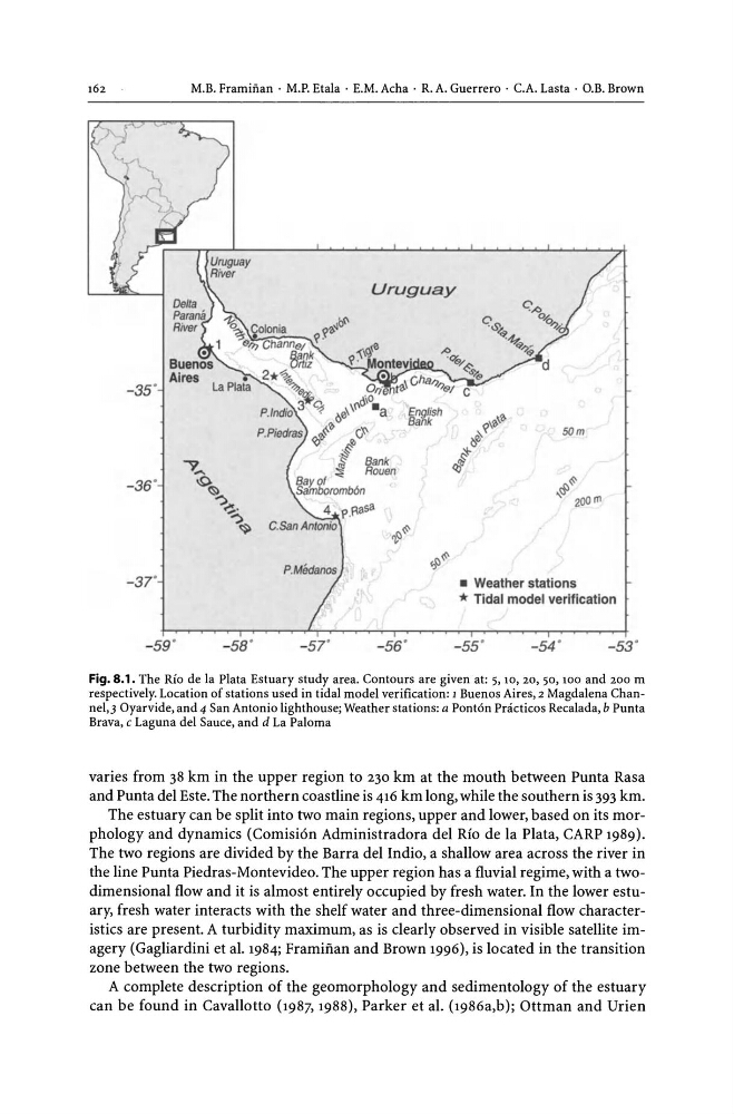
Fig. 8.1. The Rio de la Plata Estuary study area. Contours are given at: 5, 10, 20, 50, 100 and 200 m
respectively. Location of stations used in tidal model verification: 1 Buenos Aires, 2 Magdalena Channel,] Oyarvide, and 4 San Antonio lighthouse; Weather stations: a Ponton Pnicticos Recalada, b Punta
Brava, c Laguna del Sauce, and d La Paloma
varies from 38 km in the upper region to 230 km at the mouth between Punta Rasa
and Punta del Este. The northern coastline is 416 km long, while the southern is 393 km.
The estuary can be split into two main regions, upper and lower, based on its morphology and dynamics (Comision Administradora del Rio de la Plata, CARP 1989).
The two regions are divided by the Barra del Indio, a shallow area across the river in
the line Punta Piedras-Montevideo. The upper region has a fluvial regime, with a twodimensional flow and it is almost entirely occupied by fresh water. In the lower estuary, fresh water interacts with the shelf water and three-dimensional flow characteristics are present. A turbidity maximum, as is clearly observed in visible satellite imagery (Gagliardini et al. 1984; Framiftan and Brown 1996), is located in the transition
zone between the two regions.
A complete description of the geomorphology and sedimentology of the estuary
can be found in Cavallotto (1987,1988), Parker et al. (1986a,b); Ottman and Urien
Uruguay
-35'
-a 'English
\'l}'l>
Bank
~.,'?
50m
0 0
Bank
it
"'V .....
Rouen
~
-36'
O~
~~
-:>~.
'" 200 rn
-:>~
f!~
_ Weather stations
* Tidal model verification
-59 '
-58 '
-57"
-56'
-55'
-54 '
-53 '
Fig. 8.1. The Rio de la Plata Estuary study area. Contours are given at: 5, 10, 20, 50, 100 and 200 m
respectively. Location of stations used in tidal model verification: 1 Buenos Aires, 2 Magdalena Channel,] Oyarvide, and 4 San Antonio lighthouse; Weather stations: a Ponton Pnicticos Recalada, b Punta
Brava, c Laguna del Sauce, and d La Paloma
varies from 38 km in the upper region to 230 km at the mouth between Punta Rasa
and Punta del Este. The northern coastline is 416 km long, while the southern is 393 km.
The estuary can be split into two main regions, upper and lower, based on its morphology and dynamics (Comision Administradora del Rio de la Plata, CARP 1989).
The two regions are divided by the Barra del Indio, a shallow area across the river in
the line Punta Piedras-Montevideo. The upper region has a fluvial regime, with a twodimensional flow and it is almost entirely occupied by fresh water. In the lower estuary, fresh water interacts with the shelf water and three-dimensional flow characteristics are present. A turbidity maximum, as is clearly observed in visible satellite imagery (Gagliardini et al. 1984; Framiftan and Brown 1996), is located in the transition
zone between the two regions.
A complete description of the geomorphology and sedimentology of the estuary
can be found in Cavallotto (1987,1988), Parker et al. (1986a,b); Ottman and Urien