

316
9 Experimental Methods in Fluid Mechanics
at., 1992). Cotton and Carter (1994) provided a satellite calibration through
the use of monthly means of significant wave height derived for 2° latitude and
2° longitude bins between 60 0 S and 60 0 N. Monthly means from TOPEX, ERS-l
and GEOSAT altimeters have been compared against data acquired from the
NOAA's buoy network.
Comparisons of means from ERS-l and from TOPEX with those from GEOSAT, for the same calendar month but 5 years apart, indicate inter-year variability in the observed bins. Recent studies for the ERS-l altimeter showed a
satisfactory agreement for wave heights up to 4 m. Higher waves are underestimated by the altimeter, relative to the buoy data. When compared with the
WAM numerical prediction model (Massel, 1996a), the altimeter wave height
measurements showed the best agreement in the Northern Hemisphere. In the
Southern Hemisphere, the WAM model predicts wave heights lower than the
altimeter wave heights (Komen et al., 1994).
Hwang et al. (1998) compared the wind speed, wave height and wave period
derived from satellite altimeter (TOPEX/POSEIDON) and ocean buoys in the
Gulf of Mexico. The comparison showed that when separation between the
buoy location and altimeter footprint is less than 10 km and the measurement
time lag is less than 1 hour, the root-mean-square difference of the significant
wave heights is approximately 0.1 m. For the wind speed, the root-mean-square
difference is of the order of 0.8 m/s.
As was mentioned in Chap. 4, mean monthly significant wave height climatologies for the globe, based on 3-year GEOSAT radar altimeter data, were
reported by Young (1994). Recently, Young (1998) compared the ocean mean
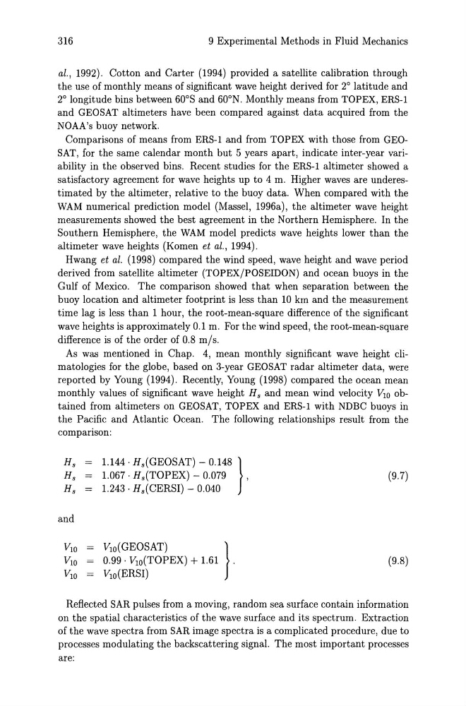
monthly values of significant wave height Hs and mean wind velocity VlO obtained from altimeters on GEOSAT, TOPEX and ERS-l with NDBC buoys in
the Pacific and Atlantic Ocean. The following relationships result from the
comparison:
Hs
Hs
Hs
and
1.144· Hs(GEOSAT) - 0.148 }
1.067· Hs(TOPEX) - 0.079
,
1.243· Hs(CERSI) - 0.040
VlO(GEOSAT)
}
0.99· VlO(TOPEX) + 1.61 .
VlO(ERSI)
(9.7)
(9.8)
Reflected SAR pulses from a moving, random sea surface contain information
on the spatial characteristics of the wave surface and its spectrum. Extraction
of the wave spectra from SAR image spectra is a complicated procedure, due to
processes modulating the backscattering signal. The most important processes
are:
9 Experimental Methods in Fluid Mechanics
at., 1992). Cotton and Carter (1994) provided a satellite calibration through
the use of monthly means of significant wave height derived for 2° latitude and
2° longitude bins between 60 0 S and 60 0 N. Monthly means from TOPEX, ERS-l
and GEOSAT altimeters have been compared against data acquired from the
NOAA's buoy network.
Comparisons of means from ERS-l and from TOPEX with those from GEOSAT, for the same calendar month but 5 years apart, indicate inter-year variability in the observed bins. Recent studies for the ERS-l altimeter showed a
satisfactory agreement for wave heights up to 4 m. Higher waves are underestimated by the altimeter, relative to the buoy data. When compared with the
WAM numerical prediction model (Massel, 1996a), the altimeter wave height
measurements showed the best agreement in the Northern Hemisphere. In the
Southern Hemisphere, the WAM model predicts wave heights lower than the
altimeter wave heights (Komen et al., 1994).
Hwang et al. (1998) compared the wind speed, wave height and wave period
derived from satellite altimeter (TOPEX/POSEIDON) and ocean buoys in the
Gulf of Mexico. The comparison showed that when separation between the
buoy location and altimeter footprint is less than 10 km and the measurement
time lag is less than 1 hour, the root-mean-square difference of the significant
wave heights is approximately 0.1 m. For the wind speed, the root-mean-square
difference is of the order of 0.8 m/s.
As was mentioned in Chap. 4, mean monthly significant wave height climatologies for the globe, based on 3-year GEOSAT radar altimeter data, were
reported by Young (1994). Recently, Young (1998) compared the ocean mean
monthly values of significant wave height Hs and mean wind velocity VlO obtained from altimeters on GEOSAT, TOPEX and ERS-l with NDBC buoys in
the Pacific and Atlantic Ocean. The following relationships result from the
comparison:
Hs
Hs
Hs
and
1.144· Hs(GEOSAT) - 0.148 }
1.067· Hs(TOPEX) - 0.079
,
1.243· Hs(CERSI) - 0.040
VlO(GEOSAT)
}
0.99· VlO(TOPEX) + 1.61 .
VlO(ERSI)
(9.7)
(9.8)
Reflected SAR pulses from a moving, random sea surface contain information
on the spatial characteristics of the wave surface and its spectrum. Extraction
of the wave spectra from SAR image spectra is a complicated procedure, due to
processes modulating the backscattering signal. The most important processes
are: