

3.2 Basic standards
79
1
CoordinateReferenceSystem
1
I
I
<
1
Datum
1
1
CoordinateSystem
1
1
1
I
I
~
I
I
I
Geodetic
11
Vertical
I Engineering 1
11
1
1
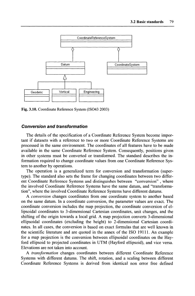
Fig. 3.10. Coordinate Reference System (lS043 2003)
Conversion and transformation
The details of the specification of a Coordinate Reference System become important if datasets with a reference to two or more Coordinate Reference Systems are
processed in the same environment. The coordinates of all features have to be made
available in the same Coordinate Reference System. Consequently, positions given
in other systems must be converted or transformed. The standard describes the information required to change coordinate values from one Coordinate Reference System to another by operations.
The operation is a generalized term for conversion and transformation (supertype). The standard also sets the frame for changing coordinates between two different Coordinate Reference Systems and distinguishes between "conversion", where
the involved Coordinate Reference Systems have the same datum, and "transformation", where the involved Co ordinate Reference Systems have different datums.
A conversion changes coordinates from one coordinate system to another based
on the same datum. In a coordinate conversion, the parameter values are exact. The
coordinate conversion includes the map projection, the coordinate conversion of ellipsoidal coordinates to 3-dimensional Cartesian coordinates, unit changes, and the
shifting of the origin towards a local grid. A map projection converts 3-dimensional
eHipsoidal coordinates (excluding the height) to 2-dimensional Cartesian coordinates. In aH cases, the conversion is based on exact formulas that are weH known in
the scientific literature and are quoted in the annex of the ISO 19111. An example
for a map projection is the conversion between ellipsoidal coordinates on the Hayford ellipsoid to projected coordinates in UTM (Hayford ellipsoid), and vice versa.
Elevations are not taken into account.
A transformation changes coordinates between different Coordinate Reference
Systems with different datums. The shift, rotation, and a scaling between different
Coordinate Reference Systems is derived from identical non error free defined
79
1
CoordinateReferenceSystem
1
I
I
<
1
Datum
1
1
CoordinateSystem
1
1
1
I
I
~
I
I
I
Geodetic
11
Vertical
I Engineering 1
11
1
1
Fig. 3.10. Coordinate Reference System (lS043 2003)
Conversion and transformation
The details of the specification of a Coordinate Reference System become important if datasets with a reference to two or more Coordinate Reference Systems are
processed in the same environment. The coordinates of all features have to be made
available in the same Coordinate Reference System. Consequently, positions given
in other systems must be converted or transformed. The standard describes the information required to change coordinate values from one Coordinate Reference System to another by operations.
The operation is a generalized term for conversion and transformation (supertype). The standard also sets the frame for changing coordinates between two different Coordinate Reference Systems and distinguishes between "conversion", where
the involved Coordinate Reference Systems have the same datum, and "transformation", where the involved Co ordinate Reference Systems have different datums.
A conversion changes coordinates from one coordinate system to another based
on the same datum. In a coordinate conversion, the parameter values are exact. The
coordinate conversion includes the map projection, the coordinate conversion of ellipsoidal coordinates to 3-dimensional Cartesian coordinates, unit changes, and the
shifting of the origin towards a local grid. A map projection converts 3-dimensional
eHipsoidal coordinates (excluding the height) to 2-dimensional Cartesian coordinates. In aH cases, the conversion is based on exact formulas that are weH known in
the scientific literature and are quoted in the annex of the ISO 19111. An example
for a map projection is the conversion between ellipsoidal coordinates on the Hayford ellipsoid to projected coordinates in UTM (Hayford ellipsoid), and vice versa.
Elevations are not taken into account.
A transformation changes coordinates between different Coordinate Reference
Systems with different datums. The shift, rotation, and a scaling between different
Coordinate Reference Systems is derived from identical non error free defined