

64
3 Non-geometry standards
«OataType»
RS Idantifier
Q8uthority{O .. 1 J : CL Citation
Qcode{O .. 1) : CharacterString
QcodeSpace[O .. 1) : CharacterS1ring
<>version[O .. 1] : CharactetString
'~ame.isTypeOf
~
I(CLCitation)=(othe~
I
I
«Enumeration»
SC KindCode
qgeneralCase : Integer - 1
Qcompound : Integer = 2
<
.Qnsme : RS Identifier
QdomainOrValidity[O .. j: Ex_Extent
-«Abstract»
SC_CRS
QkindCode : SC KindCode
(?femarks(O .. l] :-CharacterString
Lf
I
SC CoordinateReferenceS stem
I
+0 ..
.QCRSID : RS Identifier
requires
,ooalias [0 .. 1] : -CharacterString
r------'-------~~ ~lidAtea(O .. l]: Ex_Extent
Qscope [0 .. 1] : CharacterString
kindCode 1--::=:;;;;;SC~cccom"!p"ou",n:"idC=R;:;S=-_--1
2
QCCRSIDiO .. 1]: RSJdentifier
~ Qalias(O ..... J: CharacterString
......
........ QIIIalidArea(O .. l): EX_Extent
+datum 0 .. 1
SC Datum
<>datumlD : RS Identifier
QsliaslO. ,·1 : CharacterString
.otype[O .. I]: Charac1erString
.QpointIO .. l): CharacterString
~alizationEpoch[O .. 11:Date
<"ValidArea[O .. 1) : 8CExtent
Qscope[O .. "] : CharacterString
()remarks[O .. 1] : CharacterString
I
SC EngineeringDatum
I SC_GeodeticDatum J
YreQUiteS
1'+theSC_Coordinatesystem
Qscope(O ..... 1 : CharacterString
~ype - projection) implies
(Cartesian.count= 1)
(type=geodetic)implies
1-()C=S"'ID~S-';CR;;~"'OICi~~=d~;c;~"I;-,-S~"s"I,,,m--f ____ ------- (ellipsoid. count = 1)
<>type: SCßoordinateSystemType
~imension:rnteger
Qremarks(O .. l] : CharacterString
has
«Enumeration»
SC CoordinateSystemType
QCartesian
Qgeode1ic
Qprojected
Qpolar
()gravit)'Related
«Union»
SC InverseFlattening
QinverseFlattening : Real
Qislnfinite Boolean = TRUE
SC VerticalDatum
EX EKlen!
I
+primeMeridian
SC_PrimeMeridian
QmeridianlD : RS Identifier
QGreenwichLongilude : Angle
Qremarks[O .. 1]: CharacterString
(primeMeridian <> "Greenwich) implies
(GreenwichLongitude.count = 1)
+ellipsoid
SC Ellipsoid
<,?el1ipsoidID: RSJdentifier
Q8lias(O .. j : CharactetString
QsemiMajorAllis : Length
+ellipsoid
0 .. 1
<>ellipsoidShape: Saalean
()inverseFlatteningIO .. 1) : SC JnverseFlattening
Qremarks[O .. 1] CharacterString
(ordered)
+axis
Qdescription[O .. l]: CharacterString I
1 .. 3
sc _ CoordinateSystemAxis
Q8xisName : CharacterString
Q8xisOirection : CharacterString
QaxisUnitlO : UnitOfMeasure
I
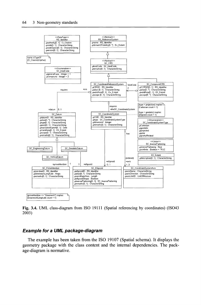
Fig. 3.4. UML class-diagram from ISO 19111 (Spatia1 referencing by coordinates) (IS043
2003)
Example for a UML package-diagram
The example has been taken from the ISO 19107 (Spatial schema). It displays the
geometry package with the class content and the internal dependencies. The package-diagram is normative.
3 Non-geometry standards
«OataType»
RS Idantifier
Q8uthority{O .. 1 J : CL Citation
Qcode{O .. 1) : CharacterString
QcodeSpace[O .. 1) : CharacterS1ring
<>version[O .. 1] : CharactetString
'~ame.isTypeOf
~
I(CLCitation)=(othe~
I
I
«Enumeration»
SC KindCode
qgeneralCase : Integer - 1
Qcompound : Integer = 2
<
.Qnsme : RS Identifier
QdomainOrValidity[O .. j: Ex_Extent
-«Abstract»
SC_CRS
QkindCode : SC KindCode
(?femarks(O .. l] :-CharacterString
Lf
I
SC CoordinateReferenceS stem
I
+0 ..
.QCRSID : RS Identifier
requires
,ooalias [0 .. 1] : -CharacterString
r------'-------~~ ~lidAtea(O .. l]: Ex_Extent
Qscope [0 .. 1] : CharacterString
kindCode 1--::=:;;;;;SC~cccom"!p"ou",n:"idC=R;:;S=-_--1
2
QCCRSIDiO .. 1]: RSJdentifier
~ Qalias(O ..... J: CharacterString
......
........ QIIIalidArea(O .. l): EX_Extent
+datum 0 .. 1
SC Datum
<>datumlD : RS Identifier
QsliaslO. ,·1 : CharacterString
.otype[O .. I]: Charac1erString
.QpointIO .. l): CharacterString
~alizationEpoch[O .. 11:Date
<"ValidArea[O .. 1) : 8CExtent
Qscope[O .. "] : CharacterString
()remarks[O .. 1] : CharacterString
I
SC EngineeringDatum
I SC_GeodeticDatum J
YreQUiteS
1'+theSC_Coordinatesystem
Qscope(O ..... 1 : CharacterString
~ype - projection) implies
(Cartesian.count= 1)
(type=geodetic)implies
1-()C=S"'ID~S-';CR;;~"'OICi~~=d~;c;~"I;-,-S~"s"I,,,m--f ____ ------- (ellipsoid. count = 1)
<>type: SCßoordinateSystemType
~imension:rnteger
Qremarks(O .. l] : CharacterString
has
«Enumeration»
SC CoordinateSystemType
QCartesian
Qgeode1ic
Qprojected
Qpolar
()gravit)'Related
«Union»
SC InverseFlattening
QinverseFlattening : Real
Qislnfinite Boolean = TRUE
SC VerticalDatum
EX EKlen!
I
+primeMeridian
SC_PrimeMeridian
QmeridianlD : RS Identifier
QGreenwichLongilude : Angle
Qremarks[O .. 1]: CharacterString
(primeMeridian <> "Greenwich) implies
(GreenwichLongitude.count = 1)
+ellipsoid
SC Ellipsoid
<,?el1ipsoidID: RSJdentifier
Q8lias(O .. j : CharactetString
QsemiMajorAllis : Length
+ellipsoid
0 .. 1
<>ellipsoidShape: Saalean
()inverseFlatteningIO .. 1) : SC JnverseFlattening
Qremarks[O .. 1] CharacterString
(ordered)
+axis
Qdescription[O .. l]: CharacterString I
1 .. 3
sc _ CoordinateSystemAxis
Q8xisName : CharacterString
Q8xisOirection : CharacterString
QaxisUnitlO : UnitOfMeasure
I
Fig. 3.4. UML class-diagram from ISO 19111 (Spatia1 referencing by coordinates) (IS043
2003)
Example for a UML package-diagram
The example has been taken from the ISO 19107 (Spatial schema). It displays the
geometry package with the class content and the internal dependencies. The package-diagram is normative.