

2.2ISO/TC211
39
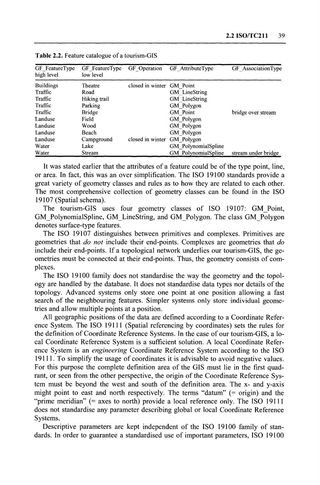
Table 2.2. Feature catalogue of a tourism-GIS
GF ]eatureType GF ]eatureType
high level
low level
Buildings
Theatre
Traffie
Road
Traffie
Hiking trail
Traffie
Parking
Traffie
Bridge
Landuse
Field
Landuse
Wood
Landuse
Beaeh
Landuse
Campground
Water
Lake
Water
Stream
GF _Operation GF _AttributeType
GF _ AssociationType
c10sed in winter GM_Point
GM _LineString
GM _ LineString
GM_Polygon
GM_Point
bridge over stream
GM]olygon
GM]olygon
GM]olygon
elosed in winter GM_Polygon
GM ]olynomialSpline
GM PolynomialSpline stream under bridge
It was stated earlier that the attributes of a feature could be of the type point, line,
or area. In fact, this was an over simplification. The ISO 19100 standards provide a
great variety of geometry classes and mIes as to how they are related to each other.
The most comprehensive collection of geometry classes can be found in the ISO
19107 (Spatial schema).
The tourism-GIS uses four geometry classes of ISO 19107: GM_Point,
GM ]olynomialSpline, GM _ LineString, and GM ]olygon. The class GM ]olygon
denotes surface-type features.
The ISO 19107 distinguishes between primitives and complexes. Primitives are
geometries that do not include their end-points. Complexes are geometries that do
include their end-points. If a topological network underlies our tourism-GIS, the geometries must be connected at their end-points. Thus, the geometry consists of complexes.
The ISO 19100 family does not standardise the way the geometry and the topology are handled by the database. It does not standardise data types nor details of the
topology. Advanced systems only store one point at one position allowing a fast
search of the neighbouring features. Simpler systems only store individual geometries and allow multiple points at a position.
All geographie positions of the data are defined according to a Co ordinate Reference System. The ISO 19111 (Spatial referencing by coordinates) sets the mIes for
the definition of Coordinate Reference Systems. In the case of our tourism-GIS, a 10cal Coordinate Reference System is a sufficient solution. A local Coordinate Reference System is an engineering Coordinate Reference System according to the ISO
19111. To simplify the usage of coordinates it is advisable to avoid negative values.
For this purpose the complete definition area of the GIS must lie in the first quadrant, or seen from the other perspective, the origin of the Coordinate Reference System must be beyond the west and south of the definition area. The x- and y-axis
might point to east and north respectively. The terms "datum" (= origin) and the
"prime meridian" (= axes to north) provide a local reference only. The ISO 19111
does not standardise any parameter describing global or local Coordinate Reference
Systems.
Descriptive parameters are kept independent of the ISO 19100 family of standards. In order to guarantee a standardised use of important parameters, ISO 19100
39
Table 2.2. Feature catalogue of a tourism-GIS
GF ]eatureType GF ]eatureType
high level
low level
Buildings
Theatre
Traffie
Road
Traffie
Hiking trail
Traffie
Parking
Traffie
Bridge
Landuse
Field
Landuse
Wood
Landuse
Beaeh
Landuse
Campground
Water
Lake
Water
Stream
GF _Operation GF _AttributeType
GF _ AssociationType
c10sed in winter GM_Point
GM _LineString
GM _ LineString
GM_Polygon
GM_Point
bridge over stream
GM]olygon
GM]olygon
GM]olygon
elosed in winter GM_Polygon
GM ]olynomialSpline
GM PolynomialSpline stream under bridge
It was stated earlier that the attributes of a feature could be of the type point, line,
or area. In fact, this was an over simplification. The ISO 19100 standards provide a
great variety of geometry classes and mIes as to how they are related to each other.
The most comprehensive collection of geometry classes can be found in the ISO
19107 (Spatial schema).
The tourism-GIS uses four geometry classes of ISO 19107: GM_Point,
GM ]olynomialSpline, GM _ LineString, and GM ]olygon. The class GM ]olygon
denotes surface-type features.
The ISO 19107 distinguishes between primitives and complexes. Primitives are
geometries that do not include their end-points. Complexes are geometries that do
include their end-points. If a topological network underlies our tourism-GIS, the geometries must be connected at their end-points. Thus, the geometry consists of complexes.
The ISO 19100 family does not standardise the way the geometry and the topology are handled by the database. It does not standardise data types nor details of the
topology. Advanced systems only store one point at one position allowing a fast
search of the neighbouring features. Simpler systems only store individual geometries and allow multiple points at a position.
All geographie positions of the data are defined according to a Co ordinate Reference System. The ISO 19111 (Spatial referencing by coordinates) sets the mIes for
the definition of Coordinate Reference Systems. In the case of our tourism-GIS, a 10cal Coordinate Reference System is a sufficient solution. A local Coordinate Reference System is an engineering Coordinate Reference System according to the ISO
19111. To simplify the usage of coordinates it is advisable to avoid negative values.
For this purpose the complete definition area of the GIS must lie in the first quadrant, or seen from the other perspective, the origin of the Coordinate Reference System must be beyond the west and south of the definition area. The x- and y-axis
might point to east and north respectively. The terms "datum" (= origin) and the
"prime meridian" (= axes to north) provide a local reference only. The ISO 19111
does not standardise any parameter describing global or local Coordinate Reference
Systems.
Descriptive parameters are kept independent of the ISO 19100 family of standards. In order to guarantee a standardised use of important parameters, ISO 19100