

30
2 Geomatics standards
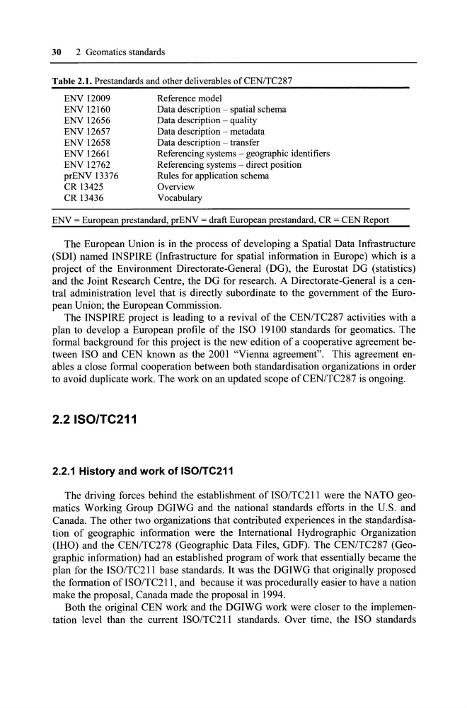
Table 2.1. Prestandards and other deliverables ofCENITC287
ENV 12009
ENV 12160
ENV 12656
ENV 12657
ENV 12658
ENV 12661
ENV 12762
prENV 13376
CR 13425
CR 13436
Reference model
Data description - spatial schema
Data description - quality
Data description - metadata
Data description - transfer
Referencing systems - geographie identifiers
Referencing systems - direct position
Rules for application schema
Overview
Vocabulary
ENV = European prestandard, prENV = draft European prestandard, CR = CEN Report
The European Union is in the proeess of developing a Spatial Data Infrastrueture
(SDI) named INSPIRE (Infrastrueture for spatial information in Europe) whieh is a
project of the Environment Direetorate-General (DG), the Eurostat DG (statisties)
and the Joint Research Centre, the DG for research. A Direetorate-General is a eentral administration level that is direetly subordinate to the government of the European Union; the European Commission.
The INSPIRE projeet is leading to a revival of the CEN/TC287 aetivities with a
plan to develop a European profile of the ISO 19100 standards for geomatics. The
formal background for this project is the new edition of a cooperative agreement between ISO and CEN known as the 2001 "Vienna agreement". This agreement enables a close formal eooperation between both standardisation organizations in order
to avoid duplicate work. The work on an updated scope of CENITC287 is ongoing.
2.2 ISO/TC211
2.2.1 History and work of ISOITC211
The driving forces behind the establishment ofISOITC211 were the NATO geomaties Working Group DGIWG and the national standards efforts in the U.S. and
Canada. The other two organizations that eontributed experienees in the standardisation of geographie information were the International Hydrographie Organization
(IHO) and the CEN/TC278 (Geographie Data Files, GDF). The CEN/TC287 (Geographie information) had an established program of work that essentially became the
plan for the ISO/TC211 base standards. It was the DGIWG that originally proposed
the formation of ISO/Te211, and beeause it was procedurally easier to have a nation
make the proposal, Canada made the proposal in 1994.
Both the original CEN work and the DGIWG work were closer to the implementation level than the eurrent ISOITC211 standards. Over time, the ISO standards
2 Geomatics standards
Table 2.1. Prestandards and other deliverables ofCENITC287
ENV 12009
ENV 12160
ENV 12656
ENV 12657
ENV 12658
ENV 12661
ENV 12762
prENV 13376
CR 13425
CR 13436
Reference model
Data description - spatial schema
Data description - quality
Data description - metadata
Data description - transfer
Referencing systems - geographie identifiers
Referencing systems - direct position
Rules for application schema
Overview
Vocabulary
ENV = European prestandard, prENV = draft European prestandard, CR = CEN Report
The European Union is in the proeess of developing a Spatial Data Infrastrueture
(SDI) named INSPIRE (Infrastrueture for spatial information in Europe) whieh is a
project of the Environment Direetorate-General (DG), the Eurostat DG (statisties)
and the Joint Research Centre, the DG for research. A Direetorate-General is a eentral administration level that is direetly subordinate to the government of the European Union; the European Commission.
The INSPIRE projeet is leading to a revival of the CEN/TC287 aetivities with a
plan to develop a European profile of the ISO 19100 standards for geomatics. The
formal background for this project is the new edition of a cooperative agreement between ISO and CEN known as the 2001 "Vienna agreement". This agreement enables a close formal eooperation between both standardisation organizations in order
to avoid duplicate work. The work on an updated scope of CENITC287 is ongoing.
2.2 ISO/TC211
2.2.1 History and work of ISOITC211
The driving forces behind the establishment ofISOITC211 were the NATO geomaties Working Group DGIWG and the national standards efforts in the U.S. and
Canada. The other two organizations that eontributed experienees in the standardisation of geographie information were the International Hydrographie Organization
(IHO) and the CEN/TC278 (Geographie Data Files, GDF). The CEN/TC287 (Geographie information) had an established program of work that essentially became the
plan for the ISO/TC211 base standards. It was the DGIWG that originally proposed
the formation of ISO/Te211, and beeause it was procedurally easier to have a nation
make the proposal, Canada made the proposal in 1994.
Both the original CEN work and the DGIWG work were closer to the implementation level than the eurrent ISOITC211 standards. Over time, the ISO standards