

260
Annexes
vector geometry
representation of geometry through the use of eonstruetive geometrie primitives
(IS0392003)
verification test
test developed to prove rigorously whether an IUT is eorreet (IS037 2000)
vertical datum
datum deseribing the relation of gravity-related heights to the Earth (lS043 2003)
NOTE
In most eases the vertieal datum will be related to a defined mean
sea level based on water level observations over a long time period. Ellipsoidal
heights are treated as related to a three-dimensional ellipsoidal eoordinate system
refereneed to a geodetie datum. Vertieal datums include sounding datums (used for
hydrographie purposes), in whieh ease the heights may be negative heights or
depths.
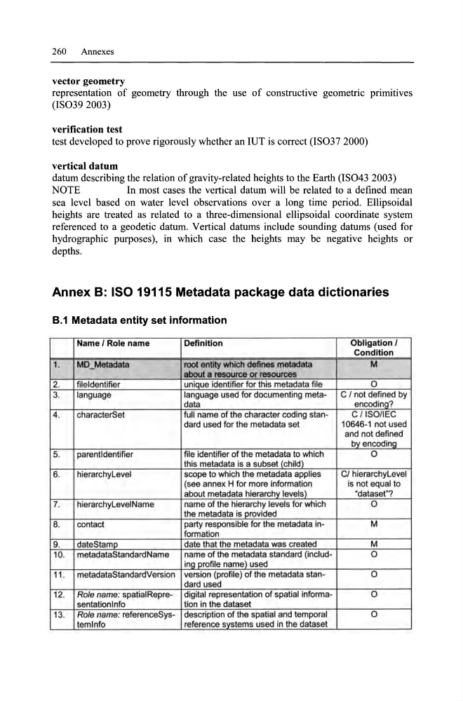
Annex B: ISO 19115 Metadata package data dictionaries
8.1 Metadata entity set information
Name I Role name
Definition
Obligation I
Condition
1.
MD_Metadata
root entity which defines metadata
M
about a resource or resources
2.
fileldentifier
unique identifier for Ihis meladala file
0
3.
language
language used for documenting metaC I not defined by
data
encoding?
4.
characlerSel
full name of the characler coding slanC/ISO/IEC
dard used for Ihe metadata sei
10646-1 not used
and not defined
byencoding
5.
parentldentifier
file identifier of Ihe meladala 10 which
0
this metadata is a subset (child)
6.
hierarchyLevel
scope to wh ich the metadata applies
CI hierarchyLevel
(see annex H for more information
is not equal to
about metadata hierarchy levels)
"dataset"?
7.
hierarchyLevelName
name of Ihe hierarchy levels for which
0
the metadala is provided
8.
contact
party responsible for the metadata inM
formation
9.
dateStamp
date that the meladala was created
M
10. metadataSlandardName
name of the metadata standard (includ0
ing profile name) used
11 . metadataStandardVersion version (profile) of the metadata stan0
dard used
12. Ro/e name: spatialRepre- digital representation of spatial informa0
sentationlnfo
tion in Ihe dataset
13. Role name: referenceSys- description of the spalial and temporal
0
lemlnfo
reference systems used in the dataset
Annexes
vector geometry
representation of geometry through the use of eonstruetive geometrie primitives
(IS0392003)
verification test
test developed to prove rigorously whether an IUT is eorreet (IS037 2000)
vertical datum
datum deseribing the relation of gravity-related heights to the Earth (lS043 2003)
NOTE
In most eases the vertieal datum will be related to a defined mean
sea level based on water level observations over a long time period. Ellipsoidal
heights are treated as related to a three-dimensional ellipsoidal eoordinate system
refereneed to a geodetie datum. Vertieal datums include sounding datums (used for
hydrographie purposes), in whieh ease the heights may be negative heights or
depths.
Annex B: ISO 19115 Metadata package data dictionaries
8.1 Metadata entity set information
Name I Role name
Definition
Obligation I
Condition
1.
MD_Metadata
root entity which defines metadata
M
about a resource or resources
2.
fileldentifier
unique identifier for Ihis meladala file
0
3.
language
language used for documenting metaC I not defined by
data
encoding?
4.
characlerSel
full name of the characler coding slanC/ISO/IEC
dard used for Ihe metadata sei
10646-1 not used
and not defined
byencoding
5.
parentldentifier
file identifier of Ihe meladala 10 which
0
this metadata is a subset (child)
6.
hierarchyLevel
scope to wh ich the metadata applies
CI hierarchyLevel
(see annex H for more information
is not equal to
about metadata hierarchy levels)
"dataset"?
7.
hierarchyLevelName
name of Ihe hierarchy levels for which
0
the metadala is provided
8.
contact
party responsible for the metadata inM
formation
9.
dateStamp
date that the meladala was created
M
10. metadataSlandardName
name of the metadata standard (includ0
ing profile name) used
11 . metadataStandardVersion version (profile) of the metadata stan0
dard used
12. Ro/e name: spatialRepre- digital representation of spatial informa0
sentationlnfo
tion in Ihe dataset
13. Role name: referenceSys- description of the spalial and temporal
0
lemlnfo
reference systems used in the dataset