

4 Geometry standards
Traditionally, graphie data falls into the two categories of vector and raster. This approach is reflected in the way the ISO 19100 standards are partitioned. The ISO
19100 standards use the more general term "gridded data" instead ofraster.
The ISO 19107 (Spatial schema) depicts a fairly complete world of vector data.
The ISO 19125-1 (Simple features access - Part 1: Common architecture) is a subset
ofISO 19107 using different terminology because ofhistoric reasons.
The ISO 19123 (Schema for coverage geometry and functions) describes
coverage data in a general sense. Coverages are often considered to be a way of
integrating the worlds of vector and raster data thus overcoming the dichotomy
originally imposed by hardware restrietions. However, coverages are restricted to
three spatial and one temporal dimension. Later they shall handle an n-dimensional
space. The ISO 19130 (Sensor and data models for imagery and gridded data)
describes the models needed to relate remotely sensed imagery data to the earth. The
ISO 19129 (Imagery, gridded and coverage data framework) is a framework standard
that describes the concepts of gridded data, lists a11 required elements, and fi11s some
gaps left over by the other standards.
4.1 Relations between the geometry standards
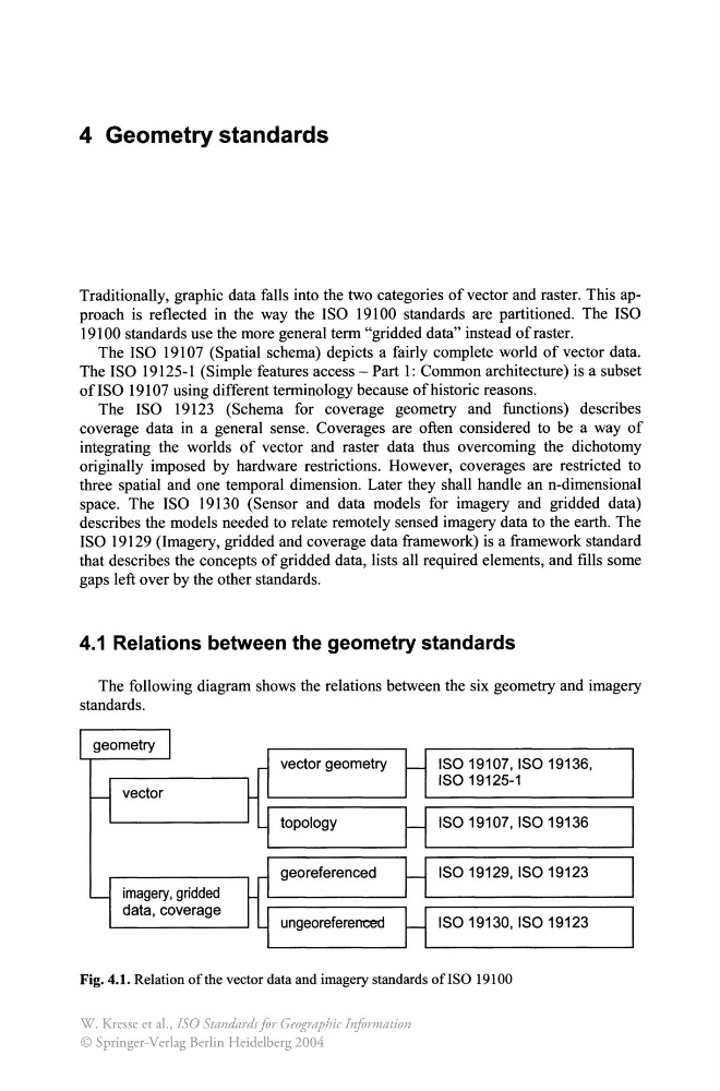
The following diagram shows the relations between the six geometry and imagery
standards.
imagery, gridded
data, coverage
vector geometry
topology
georeferenced
ungeoreferenced
ISO 19107, ISO 19136,
ISO 19125-1
ISO 19107, ISO 19136
ISO 19129, ISO 19123
ISO 19130, ISO 19123
Fig. 4.1. Relation ofthe vector data and imagery standards ofISO 19100
W. Kresse et al., ISO Standards for Geographic Information
© Springer-Verlag Berlin Heidelberg 2004
Traditionally, graphie data falls into the two categories of vector and raster. This approach is reflected in the way the ISO 19100 standards are partitioned. The ISO
19100 standards use the more general term "gridded data" instead ofraster.
The ISO 19107 (Spatial schema) depicts a fairly complete world of vector data.
The ISO 19125-1 (Simple features access - Part 1: Common architecture) is a subset
ofISO 19107 using different terminology because ofhistoric reasons.
The ISO 19123 (Schema for coverage geometry and functions) describes
coverage data in a general sense. Coverages are often considered to be a way of
integrating the worlds of vector and raster data thus overcoming the dichotomy
originally imposed by hardware restrietions. However, coverages are restricted to
three spatial and one temporal dimension. Later they shall handle an n-dimensional
space. The ISO 19130 (Sensor and data models for imagery and gridded data)
describes the models needed to relate remotely sensed imagery data to the earth. The
ISO 19129 (Imagery, gridded and coverage data framework) is a framework standard
that describes the concepts of gridded data, lists a11 required elements, and fi11s some
gaps left over by the other standards.
4.1 Relations between the geometry standards
The following diagram shows the relations between the six geometry and imagery
standards.
imagery, gridded
data, coverage
vector geometry
topology
georeferenced
ungeoreferenced
ISO 19107, ISO 19136,
ISO 19125-1
ISO 19107, ISO 19136
ISO 19129, ISO 19123
ISO 19130, ISO 19123
Fig. 4.1. Relation ofthe vector data and imagery standards ofISO 19100
W. Kresse et al., ISO Standards for Geographic Information
© Springer-Verlag Berlin Heidelberg 2004