

534
J. Ojeda Zújar et al.
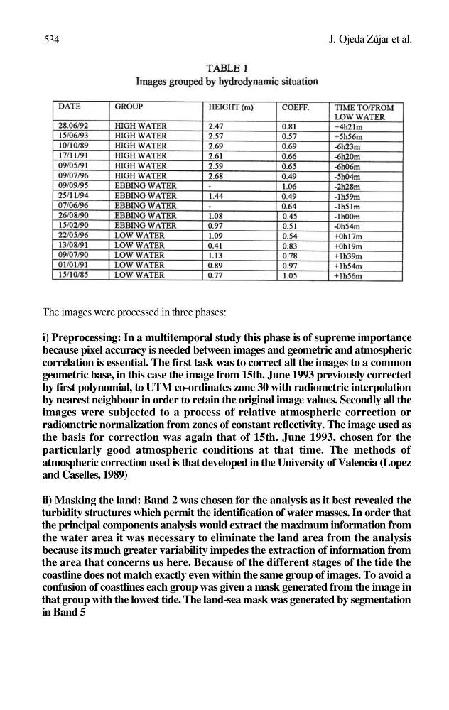
The images were processed in three phases:
i) Preprocessing: In a multitemporal study this phase is of supreme importance
because pixel accuracy is needed between images and geometric and atmospheric
correlation is essential. The first task was to correct all the images to a common
geometric base, in this case the image from 15th. June 1993 previously corrected
by first polynomial, to UTM co-ordinates zone 30 with radiometric interpolation
by nearest neighbour in order to retain the original image values. Secondly all the
images were subjected to a process of relative atmospheric correction or
radiometric normalization from zones of constant reflectivity. The image used as
the basis for correction was again that of 15th. June 1993, chosen for the
particularly good atmospheric conditions at that time. The methods of
atmospheric correction used is that developed in the University of Valencia (Lopez
and Caselles, 1989)
ii) Masking the land: Band 2 was chosen for the analysis as it best revealed the
turbidity structures which permit the identification of water masses. In order that
the principal components analysis would extract the maximum information from
the water area it was necessary to eliminate the land area from the analysis
because its much greater variability impedes the extraction of information from
the area that concerns us here. Because of the different stages of the tide the
coastline does not match exactly even within the same group of images. To avoid a
confusion of coastlines each group was given a mask generated from the image in
that group with the lowest tide. The land-sea mask was generated by segmentation
in Band 5
J. Ojeda Zújar et al.
The images were processed in three phases:
i) Preprocessing: In a multitemporal study this phase is of supreme importance
because pixel accuracy is needed between images and geometric and atmospheric
correlation is essential. The first task was to correct all the images to a common
geometric base, in this case the image from 15th. June 1993 previously corrected
by first polynomial, to UTM co-ordinates zone 30 with radiometric interpolation
by nearest neighbour in order to retain the original image values. Secondly all the
images were subjected to a process of relative atmospheric correction or
radiometric normalization from zones of constant reflectivity. The image used as
the basis for correction was again that of 15th. June 1993, chosen for the
particularly good atmospheric conditions at that time. The methods of
atmospheric correction used is that developed in the University of Valencia (Lopez
and Caselles, 1989)
ii) Masking the land: Band 2 was chosen for the analysis as it best revealed the
turbidity structures which permit the identification of water masses. In order that
the principal components analysis would extract the maximum information from
the water area it was necessary to eliminate the land area from the analysis
because its much greater variability impedes the extraction of information from
the area that concerns us here. Because of the different stages of the tide the
coastline does not match exactly even within the same group of images. To avoid a
confusion of coastlines each group was given a mask generated from the image in
that group with the lowest tide. The land-sea mask was generated by segmentation
in Band 5