

356
M.A. Chapman et al.
models for geographical data (particularly, lines, and polygons). The use of such
models in solving point-in-polygon problems is subsequently addressed.
A Decision Support Strategy
Similar to all problem solution approaches, the proposed strategy is comprised of the
key elements of problem identification, evaluation of alternative methods, and
implementation of the adopted solution to simplify a decision making process. It is
clear that the way in which a GIS is used varies between users with different skills and
responsibilities, similar to the effect of different types of decisions and application
areas. However, it is argued that to reach subsequent steps of the strategy, the lower
steps should be addressed first, and if these needs are not met, the attainment of the
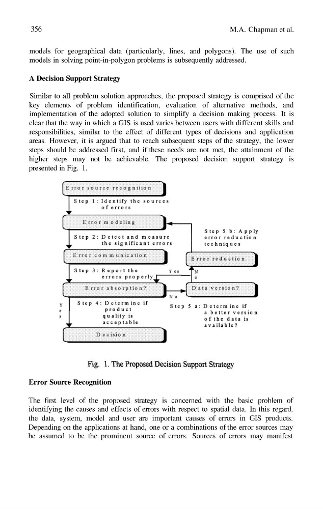
higher steps may not be achievable. The proposed decision support strategy is
presented in Fig. 1.
Error Source Recognition
The first level of the proposed strategy is concerned with the basic problem of
identifying the causes and effects of errors with respect to spatial data. In this regard,
the data, system, model and user are important causes of errors in GIS products.
Depending on the applications at hand, one or a combinations of the error sources may
be assumed to be the prominent source of errors. Sources of errors may manifest
M.A. Chapman et al.
models for geographical data (particularly, lines, and polygons). The use of such
models in solving point-in-polygon problems is subsequently addressed.
A Decision Support Strategy
Similar to all problem solution approaches, the proposed strategy is comprised of the
key elements of problem identification, evaluation of alternative methods, and
implementation of the adopted solution to simplify a decision making process. It is
clear that the way in which a GIS is used varies between users with different skills and
responsibilities, similar to the effect of different types of decisions and application
areas. However, it is argued that to reach subsequent steps of the strategy, the lower
steps should be addressed first, and if these needs are not met, the attainment of the
higher steps may not be achievable. The proposed decision support strategy is
presented in Fig. 1.
Error Source Recognition
The first level of the proposed strategy is concerned with the basic problem of
identifying the causes and effects of errors with respect to spatial data. In this regard,
the data, system, model and user are important causes of errors in GIS products.
Depending on the applications at hand, one or a combinations of the error sources may
be assumed to be the prominent source of errors. Sources of errors may manifest