

Duration of submergence
As the predicted rate of sedimentation is directly related to the length of time an area is
under water it is important to be able to estimate the elevation of any point. Other
groups within LOIS are employing a subtle method to develop an inter-tidal DTM
(digital terrain model) based on remotely sensed radar information and a
hydrodynamic model of the sea (see Mason et al. (1997) for further details).
Unfortunately this subtle DTM is not yet available and recourse has been made to the
beach profiles collected by the NRA (National Rivers Authority, see
acknowledgements). These have been collected at intervals of one kilometre along the
entire coast of the East Anglian region (from Lincolnshire to Essex). By combining the
The problems with geocorrecting imagery collected from scanning
instruments mounted on aircraft should not be underestimated as it is necessary to
know the exact location and orientation of the instrument every
of a second. To
confound matters there is very little “fixed” detail in the inter-tidal zone which can be
used for ground control. The image used in this study has a root mean square error of
approximately 25 m.
236
N.J. Brown et al.
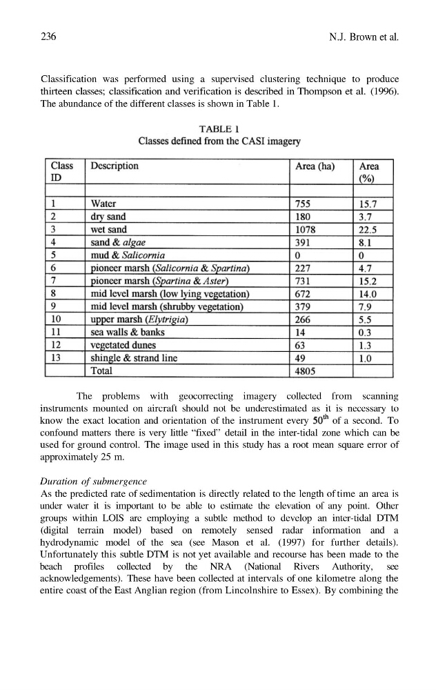
Classification was performed using a supervised clustering technique to produce
thirteen classes; classification and verification is described in Thompson et al. (1996).
The abundance of the different classes is shown in Table 1.
As the predicted rate of sedimentation is directly related to the length of time an area is
under water it is important to be able to estimate the elevation of any point. Other
groups within LOIS are employing a subtle method to develop an inter-tidal DTM
(digital terrain model) based on remotely sensed radar information and a
hydrodynamic model of the sea (see Mason et al. (1997) for further details).
Unfortunately this subtle DTM is not yet available and recourse has been made to the
beach profiles collected by the NRA (National Rivers Authority, see
acknowledgements). These have been collected at intervals of one kilometre along the
entire coast of the East Anglian region (from Lincolnshire to Essex). By combining the
The problems with geocorrecting imagery collected from scanning
instruments mounted on aircraft should not be underestimated as it is necessary to
know the exact location and orientation of the instrument every
of a second. To
confound matters there is very little “fixed” detail in the inter-tidal zone which can be
used for ground control. The image used in this study has a root mean square error of
approximately 25 m.
236
N.J. Brown et al.
Classification was performed using a supervised clustering technique to produce
thirteen classes; classification and verification is described in Thompson et al. (1996).
The abundance of the different classes is shown in Table 1.