

234
N.J. Brown et al.
investigate and describe the accumulation of sediment on the vegetated parts of a salt
marsh.
Method
STRUCTURE OF THE MODEL
A mathematical model based on analysis of field data has been constructed to estimate
the rate at which sediment accumulates on a saltmarsh. The model has been designed
to fit within the SDSS framework to allow a variety of users to investigate the
sensitivity of the assumptions made and to investigate the possible effects of sea level
rise. Analysis of field observations was carried out using stepwise linear regression for
a variety of vegetation types independently. In each case the depth of sediment
accumulated on a single tide was found to be significantly positively correlated with
the length of time an area is submerged and the amount of sediment in the water and
negatively correlated with distance from the nearest creek and the density of the
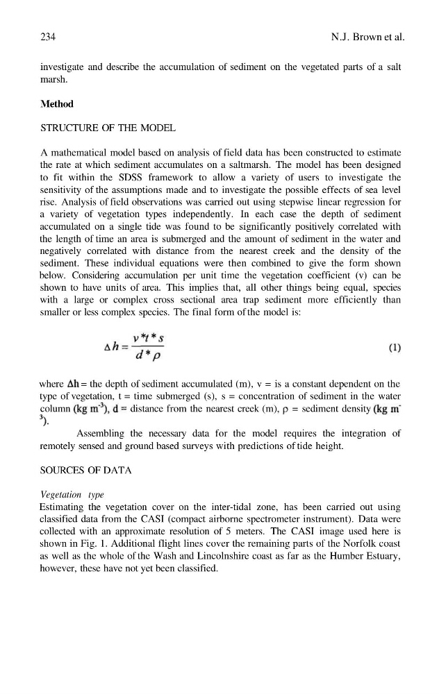
sediment. These individual equations were then combined to give the form shown
below. Considering accumulation per unit time the vegetation coefficient (v) can be
shown to have units of area. This implies that, all other things being equal, species
with a large or complex cross sectional area trap sediment more efficiently than
smaller or less complex species. The final form of the model is:
where
= the depth of sediment accumulated (m), v = is a constant dependent on the
type of vegetation, t = time submerged (s), s = concentration of sediment in the water
column
distance from the nearest creek (m), = sediment density
Assembling the necessary data for the model requires the integration of
remotely sensed and ground based surveys with predictions of tide height.
SOURCES OF DATA
Vegetation type
Estimating the vegetation cover on the inter-tidal zone, has been carried out using
classified data from the CASI (compact airborne spectrometer instrument). Data were
collected with an approximate resolution of 5 meters. The CASI image used here is
shown in Fig. 1. Additional flight lines cover the remaining parts of the Norfolk coast
as well as the whole of the Wash and Lincolnshire coast as far as the Humber Estuary,
however, these have not yet been classified.
N.J. Brown et al.
investigate and describe the accumulation of sediment on the vegetated parts of a salt
marsh.
Method
STRUCTURE OF THE MODEL
A mathematical model based on analysis of field data has been constructed to estimate
the rate at which sediment accumulates on a saltmarsh. The model has been designed
to fit within the SDSS framework to allow a variety of users to investigate the
sensitivity of the assumptions made and to investigate the possible effects of sea level
rise. Analysis of field observations was carried out using stepwise linear regression for
a variety of vegetation types independently. In each case the depth of sediment
accumulated on a single tide was found to be significantly positively correlated with
the length of time an area is submerged and the amount of sediment in the water and
negatively correlated with distance from the nearest creek and the density of the
sediment. These individual equations were then combined to give the form shown
below. Considering accumulation per unit time the vegetation coefficient (v) can be
shown to have units of area. This implies that, all other things being equal, species
with a large or complex cross sectional area trap sediment more efficiently than
smaller or less complex species. The final form of the model is:
where
= the depth of sediment accumulated (m), v = is a constant dependent on the
type of vegetation, t = time submerged (s), s = concentration of sediment in the water
column
distance from the nearest creek (m), = sediment density
Assembling the necessary data for the model requires the integration of
remotely sensed and ground based surveys with predictions of tide height.
SOURCES OF DATA
Vegetation type
Estimating the vegetation cover on the inter-tidal zone, has been carried out using
classified data from the CASI (compact airborne spectrometer instrument). Data were
collected with an approximate resolution of 5 meters. The CASI image used here is
shown in Fig. 1. Additional flight lines cover the remaining parts of the Norfolk coast
as well as the whole of the Wash and Lincolnshire coast as far as the Humber Estuary,
however, these have not yet been classified.