

188
L. P. Humphries and C. N. Ligdas
A further note on the GIS functionality should be made here. The use of the
GIS affected both the survey and data collection approaches. Once the potential for
studying spatial relationships of a variety of factors and phenomena associated with
coastal vulnerability was realised, the distribution of survey points and type of data to
be collected was reviewed. The development of a coastal GIS to study factors affecting
cliff erosion (Ligdas, 1996) in the North East coast is now being expanded to include
tools that analyse a much wider range of coastal processes. A major weakness in
proprietary GIS is the lack of statistical capabilities. This means that either code has to
be written to accommodate this or statistical analysis must be carried outside the
available GIS functions.
Conclusions
Surface analysis tools of the GIS have allowed the examination of the beaches as a
whole and the identification of spatial patterns that are unusual or anomalous with
respect to their neighbours. Elevation errors have been assessed and in conjunction
with the available spatial resolution they should be taken into account in the resulting
images.
Surface analysis identified features and possible areas of high vulnerability
that could have not been resolved by a simple profile analysis of the survey data. In
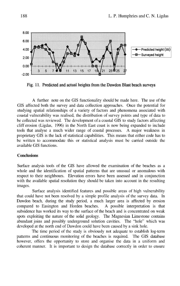
Dawdon beach, during the study period, a much larger area is affected by erosion
compared to Easington and Horden beaches. A possible interpretation is that
subsidence has worked its way to the surface of the beach and is concentrated on weak
spots exploiting the nature of the solid geology. The Magnesian Limestone contains
abundant joins and possibly underground solution cavities. The “hole” which was
developed at the north end of Dawdon could have been caused by a sink hole.
The time period of the study is obviously not adequate to establish log-term
patterns and continuous monitoring of the beaches is required. The GIS database
however, offers the opportunity to store and organise the data in a uniform and
coherent manner. It is important to design the database correctly in order to ensure
L. P. Humphries and C. N. Ligdas
A further note on the GIS functionality should be made here. The use of the
GIS affected both the survey and data collection approaches. Once the potential for
studying spatial relationships of a variety of factors and phenomena associated with
coastal vulnerability was realised, the distribution of survey points and type of data to
be collected was reviewed. The development of a coastal GIS to study factors affecting
cliff erosion (Ligdas, 1996) in the North East coast is now being expanded to include
tools that analyse a much wider range of coastal processes. A major weakness in
proprietary GIS is the lack of statistical capabilities. This means that either code has to
be written to accommodate this or statistical analysis must be carried outside the
available GIS functions.
Conclusions
Surface analysis tools of the GIS have allowed the examination of the beaches as a
whole and the identification of spatial patterns that are unusual or anomalous with
respect to their neighbours. Elevation errors have been assessed and in conjunction
with the available spatial resolution they should be taken into account in the resulting
images.
Surface analysis identified features and possible areas of high vulnerability
that could have not been resolved by a simple profile analysis of the survey data. In
Dawdon beach, during the study period, a much larger area is affected by erosion
compared to Easington and Horden beaches. A possible interpretation is that
subsidence has worked its way to the surface of the beach and is concentrated on weak
spots exploiting the nature of the solid geology. The Magnesian Limestone contains
abundant joins and possibly underground solution cavities. The “hole” which was
developed at the north end of Dawdon could have been caused by a sink hole.
The time period of the study is obviously not adequate to establish log-term
patterns and continuous monitoring of the beaches is required. The GIS database
however, offers the opportunity to store and organise the data in a uniform and
coherent manner. It is important to design the database correctly in order to ensure