

contamination.
Despite of this increasing pressure, only few researches concerning
metal concentrations in the surface sediments of the Algerian coast
were published (MPRH, 2010; Inal et al., 2014; Bachouche et al., 2017)
and none of them discussed the associated ecological risks and biological effects. Belhadj and Aubert (2017) shows that the sediments of the
Ghazaouet Bay (western Algeria) are highly polluted by Zn, Cd, Cu and
Pb issued from a large industrial complex of zinc electrolysis as well as
from leaching of tailings disposal from ore exploitation, but their data
was restricted to the bay area. These four works focused on the estimation of the pollutant load in some hot spots, and they do not give a
comprehensive view of the entire Algerian coast. However, the needs to
better know the ecological risk associated to the surface sediments was
recently emphasized by the aquaculture and fisheries development
program: “AQUAPECHE 2020” and the wholesomeness of fishing areas
and products must be now integrated. In this objective, our work presents and discusses for the first time the ecological risk that could be
associated to heavy metals in surface sediments of the Algerian coast. It
aims at helping managers from the fishing sector to evaluate the quality
of the main fishing areas, and to facilitate decisions regarding the
quality control of fishery products.
2. Study area
The Algerian coast along the southwestern side of the
Mediterranean Sea is 1300 km long and receives several rivers, the most
important being Seybousse, Lekbir and Soumam on the east, Yesser,
Sebaou, Harrach and Mazafran in the centre and Chelif, Tafna on the
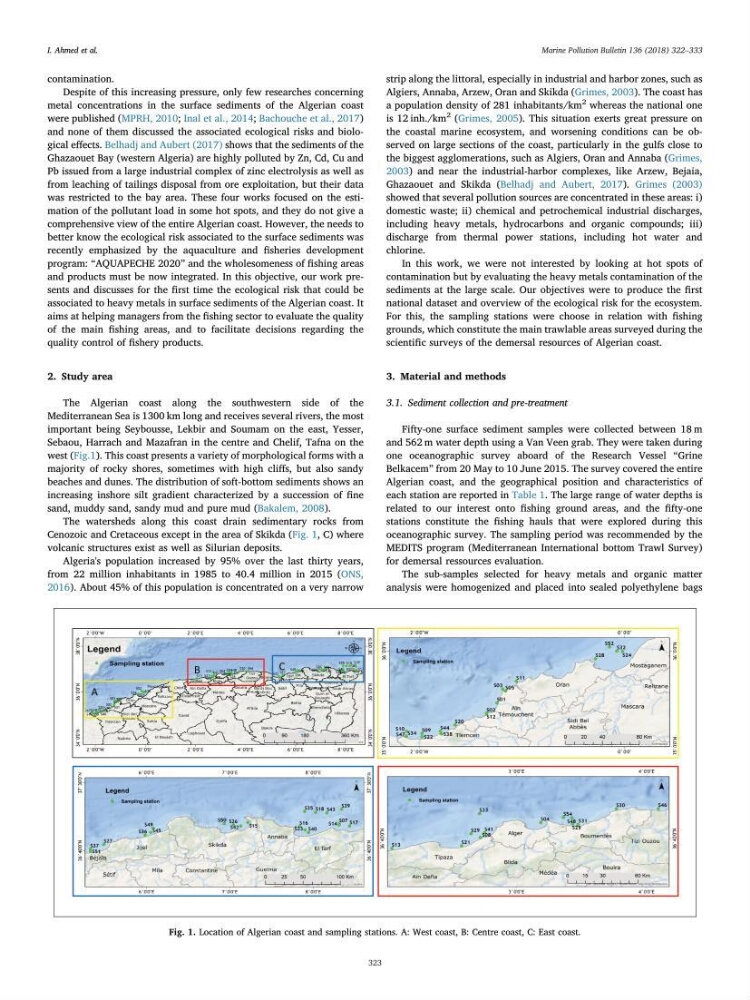
west (Fig.1). This coast presents a variety of morphological forms with a
majority of rocky shores, sometimes with high cliffs, but also sandy
beaches and dunes. The distribution of soft-bottom sediments shows an
increasing inshore silt gradient characterized by a succession of fine
sand, muddy sand, sandy mud and pure mud (Bakalem, 2008).
The watersheds along this coast drain sedimentary rocks from
Cenozoic and Cretaceous except in the area of Skikda (Fig. 1, C) where
volcanic structures exist as well as Silurian deposits.
Algeria's population increased by 95% over the last thirty years,
from 22 million inhabitants in 1985 to 40.4 million in 2015 (ONS,
2016). About 45% of this population is concentrated on a very narrow
strip along the littoral, especially in industrial and harbor zones, such as
Algiers, Annaba, Arzew, Oran and Skikda (Grimes, 2003). The coast has
a population density of 281 inhabitants/km
2 whereas the national one
is 12 inh./km
2 (Grimes, 2005). This situation exerts great pressure on
the coastal marine ecosystem, and worsening conditions can be observed on large sections of the coast, particularly in the gulfs close to
the biggest agglomerations, such as Algiers, Oran and Annaba (Grimes,
2003) and near the industrial-harbor complexes, like Arzew, Bejaia,
Ghazaouet and Skikda (Belhadj and Aubert, 2017). Grimes (2003)
showed that several pollution sources are concentrated in these areas: i)
domestic waste; ii) chemical and petrochemical industrial discharges,
including heavy metals, hydrocarbons and organic compounds; iii)
discharge from thermal power stations, including hot water and
chlorine.
In this work, we were not interested by looking at hot spots of
contamination but by evaluating the heavy metals contamination of the
sediments at the large scale. Our objectives were to produce the first
national dataset and overview of the ecological risk for the ecosystem.
For this, the sampling stations were choose in relation with fishing
grounds, which constitute the main trawlable areas surveyed during the
scientific surveys of the demersal resources of Algerian coast.
3. Material and methods
3.1. Sediment collection and pre-treatment
Fifty-one surface sediment samples were collected between 18 m
and 562 m water depth using a Van Veen grab. They were taken during
one oceanographic survey aboard of the Research Vessel “Grine
Belkacem” from 20 May to 10 June 2015. The survey covered the entire
Algerian coast, and the geographical position and characteristics of
each station are reported in Table 1. The large range of water depths is
related to our interest onto fishing ground areas, and the fifty-one
stations constitute the fishing hauls that were explored during this
oceanographic survey. The sampling period was recommended by the
MEDITS program (Mediterranean International bottom Trawl Survey)
for demersal ressources evaluation.
The sub-samples selected for heavy metals and organic matter
analysis were homogenized and placed into sealed polyethylene bags
Fig. 1. Location of Algerian coast and sampling stations. A: West coast, B: Centre coast, C: East coast.
I. Ahmed et al.
Marine Pollution Bulletin 136 (2018) 322–333
323
Despite of this increasing pressure, only few researches concerning
metal concentrations in the surface sediments of the Algerian coast
were published (MPRH, 2010; Inal et al., 2014; Bachouche et al., 2017)
and none of them discussed the associated ecological risks and biological effects. Belhadj and Aubert (2017) shows that the sediments of the
Ghazaouet Bay (western Algeria) are highly polluted by Zn, Cd, Cu and
Pb issued from a large industrial complex of zinc electrolysis as well as
from leaching of tailings disposal from ore exploitation, but their data
was restricted to the bay area. These four works focused on the estimation of the pollutant load in some hot spots, and they do not give a
comprehensive view of the entire Algerian coast. However, the needs to
better know the ecological risk associated to the surface sediments was
recently emphasized by the aquaculture and fisheries development
program: “AQUAPECHE 2020” and the wholesomeness of fishing areas
and products must be now integrated. In this objective, our work presents and discusses for the first time the ecological risk that could be
associated to heavy metals in surface sediments of the Algerian coast. It
aims at helping managers from the fishing sector to evaluate the quality
of the main fishing areas, and to facilitate decisions regarding the
quality control of fishery products.
2. Study area
The Algerian coast along the southwestern side of the
Mediterranean Sea is 1300 km long and receives several rivers, the most
important being Seybousse, Lekbir and Soumam on the east, Yesser,
Sebaou, Harrach and Mazafran in the centre and Chelif, Tafna on the
west (Fig.1). This coast presents a variety of morphological forms with a
majority of rocky shores, sometimes with high cliffs, but also sandy
beaches and dunes. The distribution of soft-bottom sediments shows an
increasing inshore silt gradient characterized by a succession of fine
sand, muddy sand, sandy mud and pure mud (Bakalem, 2008).
The watersheds along this coast drain sedimentary rocks from
Cenozoic and Cretaceous except in the area of Skikda (Fig. 1, C) where
volcanic structures exist as well as Silurian deposits.
Algeria's population increased by 95% over the last thirty years,
from 22 million inhabitants in 1985 to 40.4 million in 2015 (ONS,
2016). About 45% of this population is concentrated on a very narrow
strip along the littoral, especially in industrial and harbor zones, such as
Algiers, Annaba, Arzew, Oran and Skikda (Grimes, 2003). The coast has
a population density of 281 inhabitants/km
2 whereas the national one
is 12 inh./km
2 (Grimes, 2005). This situation exerts great pressure on
the coastal marine ecosystem, and worsening conditions can be observed on large sections of the coast, particularly in the gulfs close to
the biggest agglomerations, such as Algiers, Oran and Annaba (Grimes,
2003) and near the industrial-harbor complexes, like Arzew, Bejaia,
Ghazaouet and Skikda (Belhadj and Aubert, 2017). Grimes (2003)
showed that several pollution sources are concentrated in these areas: i)
domestic waste; ii) chemical and petrochemical industrial discharges,
including heavy metals, hydrocarbons and organic compounds; iii)
discharge from thermal power stations, including hot water and
chlorine.
In this work, we were not interested by looking at hot spots of
contamination but by evaluating the heavy metals contamination of the
sediments at the large scale. Our objectives were to produce the first
national dataset and overview of the ecological risk for the ecosystem.
For this, the sampling stations were choose in relation with fishing
grounds, which constitute the main trawlable areas surveyed during the
scientific surveys of the demersal resources of Algerian coast.
3. Material and methods
3.1. Sediment collection and pre-treatment
Fifty-one surface sediment samples were collected between 18 m
and 562 m water depth using a Van Veen grab. They were taken during
one oceanographic survey aboard of the Research Vessel “Grine
Belkacem” from 20 May to 10 June 2015. The survey covered the entire
Algerian coast, and the geographical position and characteristics of
each station are reported in Table 1. The large range of water depths is
related to our interest onto fishing ground areas, and the fifty-one
stations constitute the fishing hauls that were explored during this
oceanographic survey. The sampling period was recommended by the
MEDITS program (Mediterranean International bottom Trawl Survey)
for demersal ressources evaluation.
The sub-samples selected for heavy metals and organic matter
analysis were homogenized and placed into sealed polyethylene bags
Fig. 1. Location of Algerian coast and sampling stations. A: West coast, B: Centre coast, C: East coast.
I. Ahmed et al.
Marine Pollution Bulletin 136 (2018) 322–333
323