

188
T. Schondorf et al.
(0.5-1.2% Corg). The underlying fluvial loose gravel deposits forming the upper
aquifer contain even less organic substance (mainly below 0.1%). The unconfined
groundwater is encountered at a depth of 6 to 10 m below grade. The base of
these well-permeable gravels [hydraulic conductivity (kr) ca. 1 x 10- 3 m/s)
consists of dense, significantly weathered gravels of low permeability which
form the local aquitard.
4
Mercury Distribution in Soil
4.1
Topsoil
The total Hg concencentration is in excess of 10 mg/kg in 90% of the composite
samples and still 30% of the results gave values> 100 mg/kg to a maximum of
617 mg/kg. Individual samples even exceeded these values. The evaluation of the
individual samples shows concentration variations of up to one order of
magnitude, not only between the various sampling areas but also within sampling
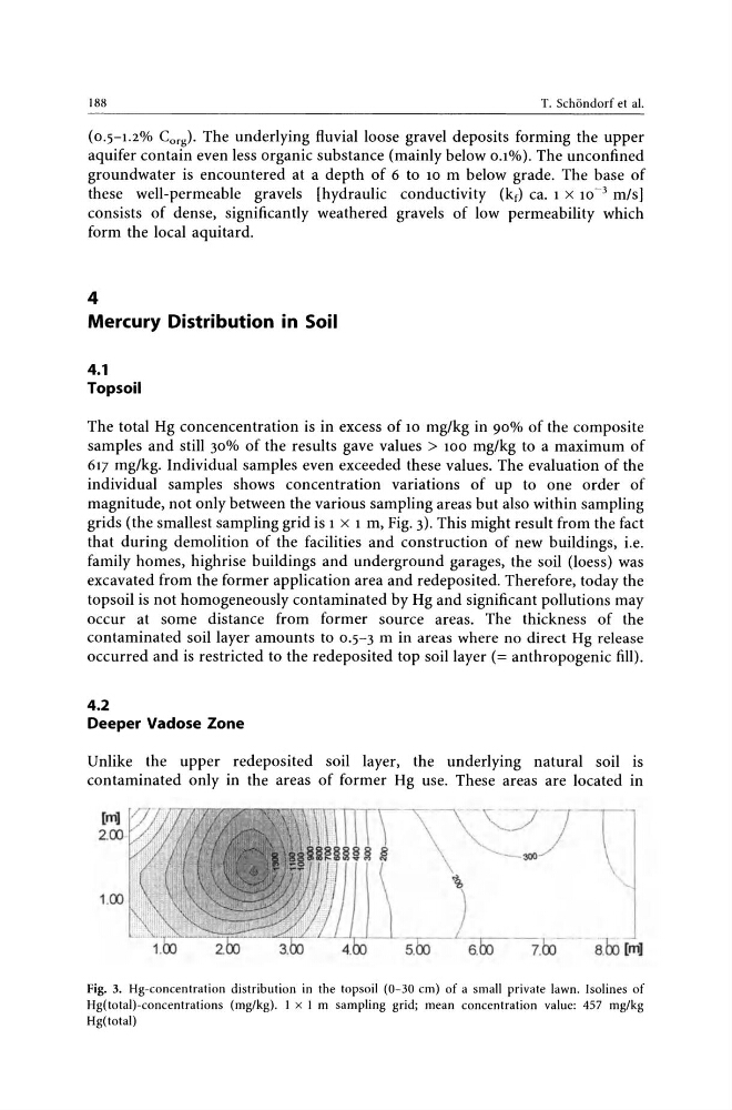
grids (the smallest sampling grid is 1 X 1 m, Fig. 3). This might result from the fact
that during demolition of the facilities and construction of new buildings, i.e.
family homes, highrise buildings and underground garages, the soil (loess) was
excavated from the former application area and redeposited. Therefore, today the
topsoil is not homogeneously contaminated by Hg and significant pollutions may
occur at some distance from former source areas. The thickness of the
contaminated soil layer amounts to 0.5-3 m in areas where no direct Hg release
occurred and is restricted to the redeposited top soil layer (= anthropogenic fill).
4.2
Deeper Vadose Zone
Unlike the upper redeposited soil layer, the underlying natural soil is
contaminated only in the areas of former Hg use. These areas are located in
-"'--J
-\
~
-,-5.00
) 00 - 006.
7.
- 8m [in]
Fig. 3. Hg-concentration distribution in the topsoil (0-30 cm) of a small private lawn. Isolines of
Hg(total)-concentrations (mg/kg). 1 x 1 m sampling grid; mean concentration value: 457 mg/kg
Hg(totai)
T. Schondorf et al.
(0.5-1.2% Corg). The underlying fluvial loose gravel deposits forming the upper
aquifer contain even less organic substance (mainly below 0.1%). The unconfined
groundwater is encountered at a depth of 6 to 10 m below grade. The base of
these well-permeable gravels [hydraulic conductivity (kr) ca. 1 x 10- 3 m/s)
consists of dense, significantly weathered gravels of low permeability which
form the local aquitard.
4
Mercury Distribution in Soil
4.1
Topsoil
The total Hg concencentration is in excess of 10 mg/kg in 90% of the composite
samples and still 30% of the results gave values> 100 mg/kg to a maximum of
617 mg/kg. Individual samples even exceeded these values. The evaluation of the
individual samples shows concentration variations of up to one order of
magnitude, not only between the various sampling areas but also within sampling
grids (the smallest sampling grid is 1 X 1 m, Fig. 3). This might result from the fact
that during demolition of the facilities and construction of new buildings, i.e.
family homes, highrise buildings and underground garages, the soil (loess) was
excavated from the former application area and redeposited. Therefore, today the
topsoil is not homogeneously contaminated by Hg and significant pollutions may
occur at some distance from former source areas. The thickness of the
contaminated soil layer amounts to 0.5-3 m in areas where no direct Hg release
occurred and is restricted to the redeposited top soil layer (= anthropogenic fill).
4.2
Deeper Vadose Zone
Unlike the upper redeposited soil layer, the underlying natural soil is
contaminated only in the areas of former Hg use. These areas are located in
-"'--J
-\
~
-,-5.00
) 00 - 006.
7.
- 8m [in]
Fig. 3. Hg-concentration distribution in the topsoil (0-30 cm) of a small private lawn. Isolines of
Hg(total)-concentrations (mg/kg). 1 x 1 m sampling grid; mean concentration value: 457 mg/kg
Hg(totai)