

Remote Sensing of Canopy Cover and IPAR
267
and the fraction occupied by sunlit leaves:
fv,sh = 1 - exp(-Kbe(O)Lr) - L$Kbe(O)(15.27)
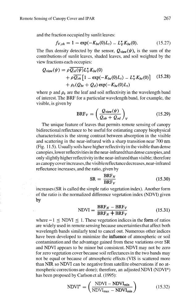
The flux density detected by the sensor, QView($), is the sum of the
contributions of sunlit leaves, shaded leaves, and soil weighted by the
view fractions each occupies:
Qview($> = PQsl($>L; Kbe(O>
+ PZ [I - exp(-Kbe(0)Lr) - L ; ~ ( o ) ] (15.28)
+
+ Qd) exp(-Kbe(O)Lt)
where p and p, are the leaf and soil reflectivity in the wavelength band
of interest. The BRF for a particular wavelength band, for example, the
visible, is given by
The unique feature of leaves that permits remote sensing of canopy
bidirectional reflectance to be useful for estimating canopy biophysical
characteristics is the strong contrast between absorption in the visible
and scattering in the near-infrared with a sharp transition near 700 nm
(Fig. 1 1.5). Usually soils have higher reflectivity in the visible than dense
canopies, lower reflectivities in the near-infrared than dense canopies, and
only slightly higher reflectivity in the near-infrared than visible; therefore
as canopy cover increases, the visible reflectance decreases, near-infrared
reflectance increases, and the ratio, given by
increases (SR is called the simple ratio vegetation index). Another form
of the ratio is the normalized difference vegetation index (NDVI) given
by
BRFN - BRFv
NDVI =
BRFN + BRFv
where - 1 5 NDVI 5 1. These vegetation indices in the form of ratios
are widely used in remote sensing because uncertainties that affect both
wavelength bands similarly tend to cancel out. Numerous other indices
have been developed to minimize the iduence of atmospheric or soil
contamination and the advantage gained from these variations over SR
and NDVI appears to be minor but consistent. NDVI may not be zero
for zero vegetation cover because soil reflectances in the two bands may
not be equal or because of atmospheric effects (VIS is scattered more
than NIR so NDVI can be negative from satellite observations if no atmospheric corrections are done); therefore, an adjusted NDVI (NDVI*)
has been proposed by Carlson et al. (1995):
NDVI - NDVIi,
NDVI* =
(15.32)
NDVI,,, - NDVI&,
267
and the fraction occupied by sunlit leaves:
fv,sh = 1 - exp(-Kbe(O)Lr) - L$Kbe(O)(15.27)
The flux density detected by the sensor, QView($), is the sum of the
contributions of sunlit leaves, shaded leaves, and soil weighted by the
view fractions each occupies:
Qview($> = PQsl($>L; Kbe(O>
+ PZ [I - exp(-Kbe(0)Lr) - L ; ~ ( o ) ] (15.28)
+
+ Qd) exp(-Kbe(O)Lt)
where p and p, are the leaf and soil reflectivity in the wavelength band
of interest. The BRF for a particular wavelength band, for example, the
visible, is given by
The unique feature of leaves that permits remote sensing of canopy
bidirectional reflectance to be useful for estimating canopy biophysical
characteristics is the strong contrast between absorption in the visible
and scattering in the near-infrared with a sharp transition near 700 nm
(Fig. 1 1.5). Usually soils have higher reflectivity in the visible than dense
canopies, lower reflectivities in the near-infrared than dense canopies, and
only slightly higher reflectivity in the near-infrared than visible; therefore
as canopy cover increases, the visible reflectance decreases, near-infrared
reflectance increases, and the ratio, given by
increases (SR is called the simple ratio vegetation index). Another form
of the ratio is the normalized difference vegetation index (NDVI) given
by
BRFN - BRFv
NDVI =
BRFN + BRFv
where - 1 5 NDVI 5 1. These vegetation indices in the form of ratios
are widely used in remote sensing because uncertainties that affect both
wavelength bands similarly tend to cancel out. Numerous other indices
have been developed to minimize the iduence of atmospheric or soil
contamination and the advantage gained from these variations over SR
and NDVI appears to be minor but consistent. NDVI may not be zero
for zero vegetation cover because soil reflectances in the two bands may
not be equal or because of atmospheric effects (VIS is scattered more
than NIR so NDVI can be negative from satellite observations if no atmospheric corrections are done); therefore, an adjusted NDVI (NDVI*)
has been proposed by Carlson et al. (1995):
NDVI - NDVIi,
NDVI* =
(15.32)
NDVI,,, - NDVI&,