

Reef Mapping
83
and this remained the only alternative to aerial photography
for remote reef mapping until the advent of satellites in
the 1970s. At the beginning of the 21st century there is
an impressive, and technologically bewildering, array of
optical devices mounted on satellites and aircraft available
for coral reef mappmg. as well as highly sophisticated
sonar devices on boats.
The common principle behind the use of remote
sensing is that coral reefs modify light or sound in a
different manner to their surroundings: coral reefs "look
different" to adjacent open water, seagrass beds, sand or
other substrates when viewed from above. In photographs,
as with satellites, it is the sun's light (usually the visible
portion of the electromagnetic spectrum) which is modified
by the coral reef, and enables it to be distinguished from
other habitats. This particular range of wavelengths of light
reflected by any subject is known as its spectral signature.
A raw image prepared by any remote sensing tool is
known as an unclassified image. To convert any such
image into a map it must be interpreted or classified.
Using digital images, one very simple approach is to
produce an unsupervised classification, in which no prior
knowledge is used, but the features on the map are
grouped together based on similar characteristics (such
as a range of shades of the same color). More useful,
particularly for the subtle but important variances in
reflectance characteristics on a coral reef, is to undertake
a supervised classification. This requires some prior
knowledge of the features to be classified, which may be
undertaken through field study (ground-truthing) or
utilizing existing independent knowledge, including maps
or photographs. Using digital techniques, mapping
software can be trained on particular localities within
an image and then extrapolated to the entire image, to
classify all areas with similar spectral signatures.
In attempting to identify the features on an image, the
interpreter is able to use considerably more than colors
reflected off the surface. A whole series of characteristics
including texture, relationships to other features, patterns
and scale can aid identification of habitats or other features in a remotely sensed image. Image interpretation can
be a highly skilled process which, if undertaken with care
and consideration, may greatly enhance the effective
resolution of an image. It is possible, for example, that a
coral patch may be too small to be picked up by a remote
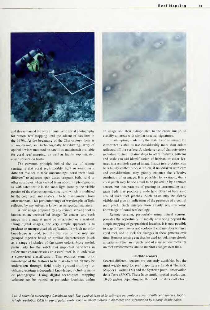
sensor, but that patterns of grazing in surrounding seagrass beds may produce a wide halo effect of bare sand
around such reef patches. Such halos may be clearly
visible and give an indication of the presence of a central
reef patch. Such interpretation clearly requires some
knowledge of coral reef ecology.
Remote sensing, particularly using optical sensors,
provides the opportunity of rapidly advancing beyond the
simple mapping of geographical location. It is now possible
to map different zones and ecological communities within a
coral reef, and to look for changes in these patterns over
time. Remote sensing can thus be used to look more closely
at patterns of human impacts, and of management measures
on reef environments, and to monitor changes over time.
Satellite sensors
Several different sensors are currently available, but the
most widely used for reef mapping are Landsat Thematic
Mapper (Landsat TM) and the Systeme pour I'observation
de la Terre (SPOT). These have similar spatial resolutions,
10-30 meters depending on the mode of data collection,
Left: A scientist surveying a Caribbean reef. The quadrat is used to estimate percentage cover of different species. Right:
A high resolution CASI image of patch reefs. Each is 20-50 meters in diameter and surrounded by clearly visible halos.
83
and this remained the only alternative to aerial photography
for remote reef mapping until the advent of satellites in
the 1970s. At the beginning of the 21st century there is
an impressive, and technologically bewildering, array of
optical devices mounted on satellites and aircraft available
for coral reef mappmg. as well as highly sophisticated
sonar devices on boats.
The common principle behind the use of remote
sensing is that coral reefs modify light or sound in a
different manner to their surroundings: coral reefs "look
different" to adjacent open water, seagrass beds, sand or
other substrates when viewed from above. In photographs,
as with satellites, it is the sun's light (usually the visible
portion of the electromagnetic spectrum) which is modified
by the coral reef, and enables it to be distinguished from
other habitats. This particular range of wavelengths of light
reflected by any subject is known as its spectral signature.
A raw image prepared by any remote sensing tool is
known as an unclassified image. To convert any such
image into a map it must be interpreted or classified.
Using digital images, one very simple approach is to
produce an unsupervised classification, in which no prior
knowledge is used, but the features on the map are
grouped together based on similar characteristics (such
as a range of shades of the same color). More useful,
particularly for the subtle but important variances in
reflectance characteristics on a coral reef, is to undertake
a supervised classification. This requires some prior
knowledge of the features to be classified, which may be
undertaken through field study (ground-truthing) or
utilizing existing independent knowledge, including maps
or photographs. Using digital techniques, mapping
software can be trained on particular localities within
an image and then extrapolated to the entire image, to
classify all areas with similar spectral signatures.
In attempting to identify the features on an image, the
interpreter is able to use considerably more than colors
reflected off the surface. A whole series of characteristics
including texture, relationships to other features, patterns
and scale can aid identification of habitats or other features in a remotely sensed image. Image interpretation can
be a highly skilled process which, if undertaken with care
and consideration, may greatly enhance the effective
resolution of an image. It is possible, for example, that a
coral patch may be too small to be picked up by a remote
sensor, but that patterns of grazing in surrounding seagrass beds may produce a wide halo effect of bare sand
around such reef patches. Such halos may be clearly
visible and give an indication of the presence of a central
reef patch. Such interpretation clearly requires some
knowledge of coral reef ecology.
Remote sensing, particularly using optical sensors,
provides the opportunity of rapidly advancing beyond the
simple mapping of geographical location. It is now possible
to map different zones and ecological communities within a
coral reef, and to look for changes in these patterns over
time. Remote sensing can thus be used to look more closely
at patterns of human impacts, and of management measures
on reef environments, and to monitor changes over time.
Satellite sensors
Several different sensors are currently available, but the
most widely used for reef mapping are Landsat Thematic
Mapper (Landsat TM) and the Systeme pour I'observation
de la Terre (SPOT). These have similar spatial resolutions,
10-30 meters depending on the mode of data collection,
Left: A scientist surveying a Caribbean reef. The quadrat is used to estimate percentage cover of different species. Right:
A high resolution CASI image of patch reefs. Each is 20-50 meters in diameter and surrounded by clearly visible halos.