

Melanesia
32s
Papua New Guinea
MAP 12a
Papua
New Guinea is one of the worlds major coral
reef nations, with a vast area of reefs. The total area
is probably considerably larger than the figure of
13 840 square kilometers provided here, as many reefs
remain unmapped in the present work. Lying on the
eastern edge of the great center of coral reef biodiversity
in Southeast Asia, there is every indication that this
country enjoys remarkably high levels of biodiversity. It
has suffered very little in terms of human impacts and
there are great opportunities for continued sustainable
management and conservation of its resources.
Papua New Guinea consists of the eastern half of
the island of New Guinea together with a large number of
smaller islands. To the west the country shares a land border
with Irian Jaya (West Papua). Indonesia. To the north of the
mainland, the Pacific Ocean becomes enclosed as the
Bismarck Sea, bounded by the Bismarck Archipelago to the
north and New Britain to the east. East of New Britain and
the mainland coast lies the Solomon Sea, further bounded
by Bougainville Island in the east and the Louisiade
Archipelago in the south. South of the mainland and the
Louisiade Archipelago is the Coral Sea, with the Gulf of
Papua and the Torres Strait to the west. The islands of the
Torres Strait are Australian, but come to within just a few
kilometers of the southern coast of Papua New Guinea. In
the southwest there are extensive coastal lowlands around
the Fly River. Further north the mainland is divided by the
long range of mountains known as the Highlands, reaching
over 3 000 meters in a number of places and more than
4 500 meters at the highest point (Mount Wilhelm). There
are further mountains along much of the north coast, divided
at the mouth of the Sepik River. The offshore islands also
show considerable relief The northern coastline and all the
islands to the north lie in a region of important tectonic
activity where the large Pacific, Australia and Caroline
tectonic plates come together, separated by a complex of
microplates underlying the Bismarck and Solomon Seas.
Papua New Guinea has a vast area of coral reefs,
including fringing, barrier and atoll formations, but there
is little information for much of the country and it seems
likely that there may still be large areas of unmapped and
possibly unknown reefs.
Mainland reefs
The north coast, pailicularly in the west, is little known,
however there are fringing reefs in many areas, including
around the nearshore chain of the Schouten Islands. East of
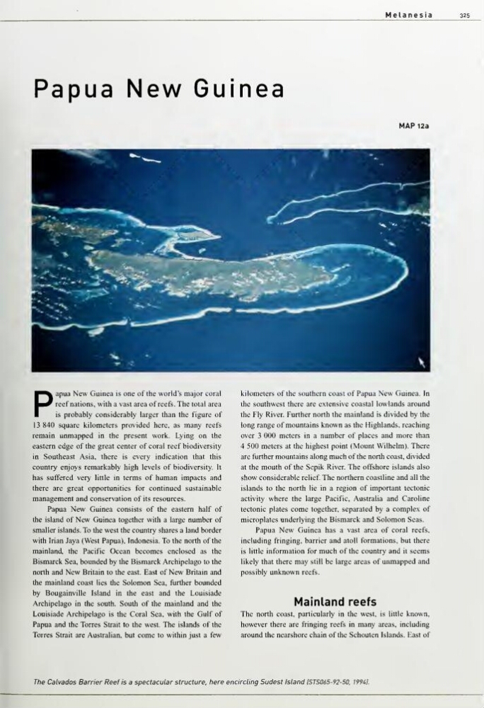
The Calvados Barrier Reef Is a spectacular structure, here encircling Sudest Island ISTS065-92-50. 199il.
32s
Papua New Guinea
MAP 12a
Papua
New Guinea is one of the worlds major coral
reef nations, with a vast area of reefs. The total area
is probably considerably larger than the figure of
13 840 square kilometers provided here, as many reefs
remain unmapped in the present work. Lying on the
eastern edge of the great center of coral reef biodiversity
in Southeast Asia, there is every indication that this
country enjoys remarkably high levels of biodiversity. It
has suffered very little in terms of human impacts and
there are great opportunities for continued sustainable
management and conservation of its resources.
Papua New Guinea consists of the eastern half of
the island of New Guinea together with a large number of
smaller islands. To the west the country shares a land border
with Irian Jaya (West Papua). Indonesia. To the north of the
mainland, the Pacific Ocean becomes enclosed as the
Bismarck Sea, bounded by the Bismarck Archipelago to the
north and New Britain to the east. East of New Britain and
the mainland coast lies the Solomon Sea, further bounded
by Bougainville Island in the east and the Louisiade
Archipelago in the south. South of the mainland and the
Louisiade Archipelago is the Coral Sea, with the Gulf of
Papua and the Torres Strait to the west. The islands of the
Torres Strait are Australian, but come to within just a few
kilometers of the southern coast of Papua New Guinea. In
the southwest there are extensive coastal lowlands around
the Fly River. Further north the mainland is divided by the
long range of mountains known as the Highlands, reaching
over 3 000 meters in a number of places and more than
4 500 meters at the highest point (Mount Wilhelm). There
are further mountains along much of the north coast, divided
at the mouth of the Sepik River. The offshore islands also
show considerable relief The northern coastline and all the
islands to the north lie in a region of important tectonic
activity where the large Pacific, Australia and Caroline
tectonic plates come together, separated by a complex of
microplates underlying the Bismarck and Solomon Seas.
Papua New Guinea has a vast area of coral reefs,
including fringing, barrier and atoll formations, but there
is little information for much of the country and it seems
likely that there may still be large areas of unmapped and
possibly unknown reefs.
Mainland reefs
The north coast, pailicularly in the west, is little known,
however there are fringing reefs in many areas, including
around the nearshore chain of the Schouten Islands. East of
The Calvados Barrier Reef Is a spectacular structure, here encircling Sudest Island ISTS065-92-50. 199il.