

Southeast Asia
281
Philippines
MAPS 10f and g
k
ik^'
Hi^^E'
i
C
iHi
,f
"^^ i1 m
Wbr
V
IR^.
^.
The
Philippines are a large and complex mass of
over 7 000 islands making up the north of insular
Southeast Asia. Together with Indonesia to the
south, the Philippines lie in the center of global coral reef
biodiversity and have a vast area of reefs.
In the far north the archipelago commences with the
Batanes and Babuyan Islands in the Luzon Strait, just south
of Taiwan. The northern third of Luzon itself is highly
mountainous and parts remain heavily forested, while the
central parts are predominantly agricultural with large areas
of low-lying land. Relatively close to Luzon are the islands
of Mindoro and Marinduque. the former mountainous and
still largely under forest. South of Luzon lies a complex
mass of islands known as the Visayas, including Panay,
Negros, Cebu, Bohol, Leyte and Samar, centered around
the Visayan Sea which, despite the tight configuration of
islands, reaches a depth of more than 200 meters in some
places. The southernmost major island is Mindanao, which
lies separated from the Visayas by the Bohol Sea. This is
another mountainous island, with a narrow shelf on all
sides. The Philippines Trench to the east of Mindanao and
Samar reaches depths of more than 10 000 meters at a distance of less than 80 kilometers from shore. Stretching to
the southwest from Mindanao is a chain of islands known
as the Sulu Archipelago, coming close to the coastline of
Sabah in Malaysia and separating the Sulawesi (Celebes)
Sea in the south from the Sulu Sea to the north. There are
several remote islands and atolls in the central Sulu Sea,
while its northern edge is marked by the long mountainous
island of Palawan as well as various smaller ones.
The eastern side of the country borders the Philippine
Sea and the Pacific Ocean and is affected by the ocean
currents of the Pacific. The North Equatorial Current
reaches this coastline and divides, with a northward
branch flowing up the coast of the Visayas and Luzon,
becoming the Kuroshio Current as it flows towards Taiwan
and Japan. The southward branch flows along the east
coast of Mindanao as the Mindanao Current. The western
side of the country, facing the South China and Sulu Seas,
is more directly affected by the reversing pattern of the
monsoon winds.
Fringing reefs are well developed around the Batanes
and Babuyan Islands, although live coral cover on the
former is reported as low (less than 25 percent). Around
Luzon itself reefs are by no means continuous. There are no
recorded reefs in the far northwest, and the first to appear
on this coast are fringing structures around the Hundred
Islands, an area in the Lingayen Gulf. The waters here may
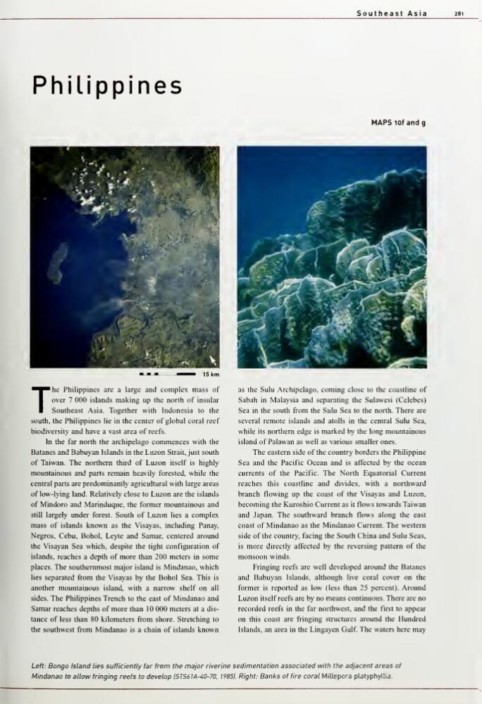
Left: Bongo Island lies sufficiently far from the major riverine sedimentation associated with the adjacent areas of
Mindanao to allow fringing reefs to develop ISTS61A-40-70, 19851. Right: Banks of fire coral Millepora platyphyUia.
281
Philippines
MAPS 10f and g
k
ik^'
Hi^^E'
i
C
iHi
,f
"^^ i1 m
Wbr
V
IR^.
^.
The
Philippines are a large and complex mass of
over 7 000 islands making up the north of insular
Southeast Asia. Together with Indonesia to the
south, the Philippines lie in the center of global coral reef
biodiversity and have a vast area of reefs.
In the far north the archipelago commences with the
Batanes and Babuyan Islands in the Luzon Strait, just south
of Taiwan. The northern third of Luzon itself is highly
mountainous and parts remain heavily forested, while the
central parts are predominantly agricultural with large areas
of low-lying land. Relatively close to Luzon are the islands
of Mindoro and Marinduque. the former mountainous and
still largely under forest. South of Luzon lies a complex
mass of islands known as the Visayas, including Panay,
Negros, Cebu, Bohol, Leyte and Samar, centered around
the Visayan Sea which, despite the tight configuration of
islands, reaches a depth of more than 200 meters in some
places. The southernmost major island is Mindanao, which
lies separated from the Visayas by the Bohol Sea. This is
another mountainous island, with a narrow shelf on all
sides. The Philippines Trench to the east of Mindanao and
Samar reaches depths of more than 10 000 meters at a distance of less than 80 kilometers from shore. Stretching to
the southwest from Mindanao is a chain of islands known
as the Sulu Archipelago, coming close to the coastline of
Sabah in Malaysia and separating the Sulawesi (Celebes)
Sea in the south from the Sulu Sea to the north. There are
several remote islands and atolls in the central Sulu Sea,
while its northern edge is marked by the long mountainous
island of Palawan as well as various smaller ones.
The eastern side of the country borders the Philippine
Sea and the Pacific Ocean and is affected by the ocean
currents of the Pacific. The North Equatorial Current
reaches this coastline and divides, with a northward
branch flowing up the coast of the Visayas and Luzon,
becoming the Kuroshio Current as it flows towards Taiwan
and Japan. The southward branch flows along the east
coast of Mindanao as the Mindanao Current. The western
side of the country, facing the South China and Sulu Seas,
is more directly affected by the reversing pattern of the
monsoon winds.
Fringing reefs are well developed around the Batanes
and Babuyan Islands, although live coral cover on the
former is reported as low (less than 25 percent). Around
Luzon itself reefs are by no means continuous. There are no
recorded reefs in the far northwest, and the first to appear
on this coast are fringing structures around the Hundred
Islands, an area in the Lingayen Gulf. The waters here may
Left: Bongo Island lies sufficiently far from the major riverine sedimentation associated with the adjacent areas of
Mindanao to allow fringing reefs to develop ISTS61A-40-70, 19851. Right: Banks of fire coral Millepora platyphyUia.