

Western Indian Ocean
197
MayottGp Comoros and
outlying islands
MAP 76
13 km
There
are a number of small oceanic islands lying
between Mozambique and Madagascar The most
important of these are the four large volcanic
islands of the Comoros Archipelago situated at the
northern entrance to this channel. Mayotte, the easternmost of these islands is a collectivite territoriale under
French control, while the remaining islands form the
Federal Islamic Republic of the Comoros. Mayotte is
geologically the oldest and is surrounded by a wide lagoon
which reaches 70 meters in depth before a barrier reef
some 3-15 kilometers offshore. The remaining islands are
surrounded by fringing reefs, although Ngazidja (Grande
Comore), the youngest island which is still volcanically
active, has very steep and barren shores and fringing reefs
are restricted to only a few parts of the coastline. Mwali
(Moheli) has the most extensive reef systems, with
fringing reefs on all coasts. East of these islands lies the
Banc du Geyser/Zelee (Map 7d), a horseshoe-shaped reef
which is probably part of the same volcanic system. This
reef breaks the surface during low tides, and lies between
Mayotte and the French territory of lies Glorieuses. All
of these reefs lie in the path of the westward flowing
Equatorial Counter Current, which coincides with the
northern leg of the Mozambique Gyre.
Mayotte
Mayotte "s reefs are relatively well studied, and harbor more
than 200 species of coral. They were adversely affected by
a bleaching event in 1982-83, which apparently caused mortality and degradation on about 36 percent of the fringing
reefs. Crown-of-thorns starfish outbreaks since 1983 have
been a major problem, although a bounty system resulted in
fishermen collecting large numbers, with a peak of some
8 000 collected in 1998. The 1998 bleaching event caused
even more widespread mortality, with greater than 90 percent mortality recorded on the outer slopes. Recovery from
this event is now being noted particularly on the inshore
reefs. Fisheries and tourism are important activities, with
some 3 600 fishermen and 9 000 visitor arrivals per year in
the late 1990s. Two protected areas have been established,
although these only cover some 2 percent of the total area
of the lagoon. A comprehensive management plan for the
lagoon was under development in late 2000.
Comoros
The densely populated Comoros is one of the world's
poorest countries. Deforestation and conversion of land to
agriculture are creating massive problems of soil erosion.
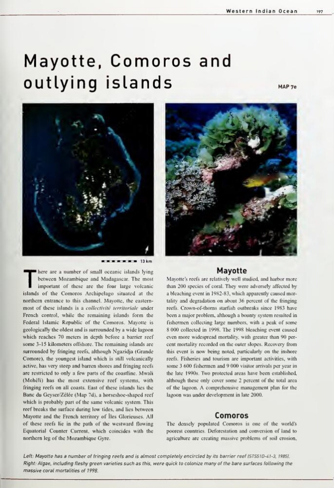
Left: Mayotte has a number of fringing reefs and is almost completely encircled by its barrier reef ISTS5W-41-3, 19851.
Right: Algae, including fleshy green varieties such as this, were quick to colonize many of the bare surfaces following the
massive coral mortalities of 1998.
197
MayottGp Comoros and
outlying islands
MAP 76
13 km
There
are a number of small oceanic islands lying
between Mozambique and Madagascar The most
important of these are the four large volcanic
islands of the Comoros Archipelago situated at the
northern entrance to this channel. Mayotte, the easternmost of these islands is a collectivite territoriale under
French control, while the remaining islands form the
Federal Islamic Republic of the Comoros. Mayotte is
geologically the oldest and is surrounded by a wide lagoon
which reaches 70 meters in depth before a barrier reef
some 3-15 kilometers offshore. The remaining islands are
surrounded by fringing reefs, although Ngazidja (Grande
Comore), the youngest island which is still volcanically
active, has very steep and barren shores and fringing reefs
are restricted to only a few parts of the coastline. Mwali
(Moheli) has the most extensive reef systems, with
fringing reefs on all coasts. East of these islands lies the
Banc du Geyser/Zelee (Map 7d), a horseshoe-shaped reef
which is probably part of the same volcanic system. This
reef breaks the surface during low tides, and lies between
Mayotte and the French territory of lies Glorieuses. All
of these reefs lie in the path of the westward flowing
Equatorial Counter Current, which coincides with the
northern leg of the Mozambique Gyre.
Mayotte
Mayotte "s reefs are relatively well studied, and harbor more
than 200 species of coral. They were adversely affected by
a bleaching event in 1982-83, which apparently caused mortality and degradation on about 36 percent of the fringing
reefs. Crown-of-thorns starfish outbreaks since 1983 have
been a major problem, although a bounty system resulted in
fishermen collecting large numbers, with a peak of some
8 000 collected in 1998. The 1998 bleaching event caused
even more widespread mortality, with greater than 90 percent mortality recorded on the outer slopes. Recovery from
this event is now being noted particularly on the inshore
reefs. Fisheries and tourism are important activities, with
some 3 600 fishermen and 9 000 visitor arrivals per year in
the late 1990s. Two protected areas have been established,
although these only cover some 2 percent of the total area
of the lagoon. A comprehensive management plan for the
lagoon was under development in late 2000.
Comoros
The densely populated Comoros is one of the world's
poorest countries. Deforestation and conversion of land to
agriculture are creating massive problems of soil erosion.
Left: Mayotte has a number of fringing reefs and is almost completely encircled by its barrier reef ISTS5W-41-3, 19851.
Right: Algae, including fleshy green varieties such as this, were quick to colonize many of the bare surfaces following the
massive coral mortalities of 1998.