

Northern Caribbean
Bermuda
MAP 4b
Bermuda
is an isolated group of 150 limestone
islands in the Sargasso Sea area of the Western
North Atlantic Ocean more than 1 000 kilometers
from continental USA. Most of the land area is represented by five islands which are joined together by
causeways. These islands are the high points of the
Bermuda Platform - the nearby Plantagenet and
Challenger Banks rise to 50 meters below sea level.
Together the three banks crown the Bermuda Rise, a midplate hotspot of similar origin to Hawai'i, although geologically older. Water in excess of 8 000 meters depth
occurs just 6 kilometers to the northwest of Bermuda, as the
sides of the Bermuda Rise fall steeply to the ocean floor.
The Bermuda Platform is 1 400 kilometers from
the nearest hermatypic coral reefs, in Florida and the
Bahamas, yet supports the northernmost coral reefs of
the Atlantic. A sub-tropical climate maintains shallow
water temperatures above 19°C in winter, with a summer
maximum of 27°C. The northerly occurrence of such
warm temperatures, at a similar latitude to the Canary
Islands, is due to the Gulf Stream which passes to the
north and west of Bermuda.
The reef flora and fauna of Bermuda are much less
diverse than in the Caribbean. Only one third of Caribbean
corals occur here, with the most notable absence being the
genus Acropora. Approximately 120 species of reef fish
have been recorded. Fringing, bank barrier and lagoonal
patch reefs are found on the Bermuda Platform and the
health of these small reefs is good overall. Coral cover
averaged 30-35 percent in 2000, reaching 50 percent on
the outer terrace. Grazing by parrotfishes and surgeonfishes was sufficient to prevent even a temporary increase
in the cover of fleshy algae after most of the Diadema
died in 1983.
Bermuda has a very high human population density.
It also enjoys one of the highest per-capita incomes in
the world, through both the provision of financial services and the development of luxury tourist facilities for
600 000 annual visitors. The tourist industry accounts
for an estimated 28 percent of gross domestic product and
attracts 84 percent of its business from North America.
The industrial sector is small, and agriculture is severely
limited by a lack of suitable land. Domestic waste is
the main source of terrestrial pollution. The occasional
grounding of large vessels is also a problem for the reefs.
Queen conch are reported to be commercially extinct, but
other reef fisheries are at a low level and appear to be
HH^^^
Bermu da
^^
General Data
Population (thousands)
63
GDPImillion US$1
1 797
Land area Ikm^l
39
Marine area (thousand km^l
450
Per capita fish consumption (kg/year)
UU
Status and Threats
Reefs at risk (%|
100
Recorded coral diseases
2
Biodiversity
Reef area (km^l
370
Coral diversity
26 /na
Mangrove area (km^)
0.16
No. of mangrove species
3
No. of seagrass species
U
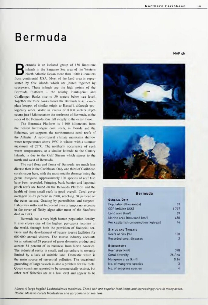
Above: A large hogfish Lachnolaimus maximus. These fish are popular food items and increasingly rare in many areas.
Below: Massive corals Montastrea and gorgonians or sea fans.
Bermuda
MAP 4b
Bermuda
is an isolated group of 150 limestone
islands in the Sargasso Sea area of the Western
North Atlantic Ocean more than 1 000 kilometers
from continental USA. Most of the land area is represented by five islands which are joined together by
causeways. These islands are the high points of the
Bermuda Platform - the nearby Plantagenet and
Challenger Banks rise to 50 meters below sea level.
Together the three banks crown the Bermuda Rise, a midplate hotspot of similar origin to Hawai'i, although geologically older. Water in excess of 8 000 meters depth
occurs just 6 kilometers to the northwest of Bermuda, as the
sides of the Bermuda Rise fall steeply to the ocean floor.
The Bermuda Platform is 1 400 kilometers from
the nearest hermatypic coral reefs, in Florida and the
Bahamas, yet supports the northernmost coral reefs of
the Atlantic. A sub-tropical climate maintains shallow
water temperatures above 19°C in winter, with a summer
maximum of 27°C. The northerly occurrence of such
warm temperatures, at a similar latitude to the Canary
Islands, is due to the Gulf Stream which passes to the
north and west of Bermuda.
The reef flora and fauna of Bermuda are much less
diverse than in the Caribbean. Only one third of Caribbean
corals occur here, with the most notable absence being the
genus Acropora. Approximately 120 species of reef fish
have been recorded. Fringing, bank barrier and lagoonal
patch reefs are found on the Bermuda Platform and the
health of these small reefs is good overall. Coral cover
averaged 30-35 percent in 2000, reaching 50 percent on
the outer terrace. Grazing by parrotfishes and surgeonfishes was sufficient to prevent even a temporary increase
in the cover of fleshy algae after most of the Diadema
died in 1983.
Bermuda has a very high human population density.
It also enjoys one of the highest per-capita incomes in
the world, through both the provision of financial services and the development of luxury tourist facilities for
600 000 annual visitors. The tourist industry accounts
for an estimated 28 percent of gross domestic product and
attracts 84 percent of its business from North America.
The industrial sector is small, and agriculture is severely
limited by a lack of suitable land. Domestic waste is
the main source of terrestrial pollution. The occasional
grounding of large vessels is also a problem for the reefs.
Queen conch are reported to be commercially extinct, but
other reef fisheries are at a low level and appear to be
HH^^^
Bermu da
^^
General Data
Population (thousands)
63
GDPImillion US$1
1 797
Land area Ikm^l
39
Marine area (thousand km^l
450
Per capita fish consumption (kg/year)
UU
Status and Threats
Reefs at risk (%|
100
Recorded coral diseases
2
Biodiversity
Reef area (km^l
370
Coral diversity
26 /na
Mangrove area (km^)
0.16
No. of mangrove species
3
No. of seagrass species
U
Above: A large hogfish Lachnolaimus maximus. These fish are popular food items and increasingly rare in many areas.
Below: Massive corals Montastrea and gorgonians or sea fans.