

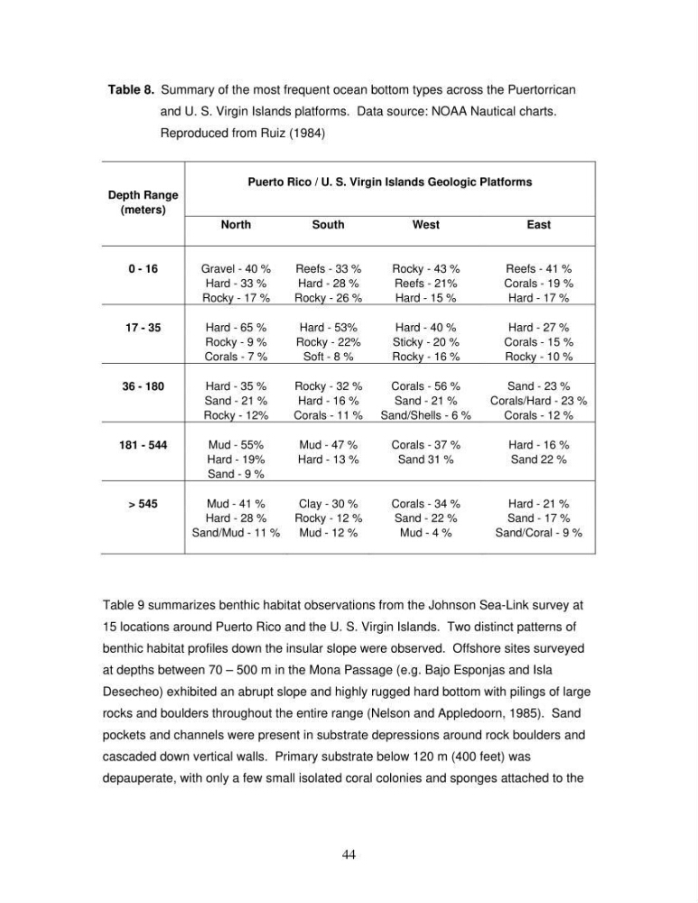
Table 8. Summary of the most frequent ocean bottom types across the Puertorrica
and U. S. Virgin Islands platforms. Data source: NOAA Nautical charts.
Reproduced from Ruiz (1984)
n
Puerto Rico / U. S. Virgin Islands Geologic Platforms
Depth Range
(meters)
North
South
West
East
0 - 16
Gravel - 40 %
Reefs - 33 %
Rocky - 43 %
Reefs - 41 %
Hard - 33 %
Hard - 28 %
Reefs - 21%
Corals - 19 %
Rocky - 17 %
Rocky - 26 %
Hard - 15 %
Hard - 17 %
17 - 35
Hard - 65 %
Hard - 53%
Hard - 40 %
Hard - 27 %
Rocky - 9 %
Rocky - 22%
Sticky - 20 %
Corals - 15 %
Corals - 7 %
Soft - 8 %
Rocky - 16 %
Rocky - 10 %
36 - 180
Hard - 35 %
Rocky - 32 %
Corals - 56 %
Sand - 23 %
Sand - 21 %
Hard - 16 %
Sand - 21 %
Corals/Hard - 23 %
Rocky - 12%
Corals - 11 %
Sand/Shells - 6 %
Corals - 12 %
181 - 544
Mud - 55%
Mud - 47 %
Corals - 37 %
Hard - 16 %
Hard - 19%
Hard - 13 %
Sand 31 %
Sand 22 %
Sand - 9 %
> 545
Mud - 41 %
Clay - 30 %
Corals - 34 %
Hard - 21 %
Hard - 28 %
Rocky - 12 %
Sand - 22 %
Sand - 17 %
Sand/Mud - 11 %
Mud - 12 %
Mud - 4 %
Sand/Coral - 9 %
Table 9 summarizes benthic habitat observations from the Johnson Sea-Link survey at
15 locations around Puerto Rico and the U. S. Virgin Islands. Two distinct patterns of
benthic habitat profiles down the insular slope were observed. Offshore sites surveyed
at depths between 70 – 500 m in the Mona Passage (e.g. Bajo Esponjas and Isla
Desecheo) exhibited an abrupt slope and highly rugged hard bottom with pilings of large
rocks and boulders throughout the entire range (Nelson and Appledoorn, 1985). Sand
pockets and channels were present in substrate depressions around rock boulders and
cascaded down vertical walls. Primary substrate below 120 m (400 feet) was
depauperate, with only a few small isolated coral colonies and sponges attached to the
44
and U. S. Virgin Islands platforms. Data source: NOAA Nautical charts.
Reproduced from Ruiz (1984)
n
Puerto Rico / U. S. Virgin Islands Geologic Platforms
Depth Range
(meters)
North
South
West
East
0 - 16
Gravel - 40 %
Reefs - 33 %
Rocky - 43 %
Reefs - 41 %
Hard - 33 %
Hard - 28 %
Reefs - 21%
Corals - 19 %
Rocky - 17 %
Rocky - 26 %
Hard - 15 %
Hard - 17 %
17 - 35
Hard - 65 %
Hard - 53%
Hard - 40 %
Hard - 27 %
Rocky - 9 %
Rocky - 22%
Sticky - 20 %
Corals - 15 %
Corals - 7 %
Soft - 8 %
Rocky - 16 %
Rocky - 10 %
36 - 180
Hard - 35 %
Rocky - 32 %
Corals - 56 %
Sand - 23 %
Sand - 21 %
Hard - 16 %
Sand - 21 %
Corals/Hard - 23 %
Rocky - 12%
Corals - 11 %
Sand/Shells - 6 %
Corals - 12 %
181 - 544
Mud - 55%
Mud - 47 %
Corals - 37 %
Hard - 16 %
Hard - 19%
Hard - 13 %
Sand 31 %
Sand 22 %
Sand - 9 %
> 545
Mud - 41 %
Clay - 30 %
Corals - 34 %
Hard - 21 %
Hard - 28 %
Rocky - 12 %
Sand - 22 %
Sand - 17 %
Sand/Mud - 11 %
Mud - 12 %
Mud - 4 %
Sand/Coral - 9 %
Table 9 summarizes benthic habitat observations from the Johnson Sea-Link survey at
15 locations around Puerto Rico and the U. S. Virgin Islands. Two distinct patterns of
benthic habitat profiles down the insular slope were observed. Offshore sites surveyed
at depths between 70 – 500 m in the Mona Passage (e.g. Bajo Esponjas and Isla
Desecheo) exhibited an abrupt slope and highly rugged hard bottom with pilings of large
rocks and boulders throughout the entire range (Nelson and Appledoorn, 1985). Sand
pockets and channels were present in substrate depressions around rock boulders and
cascaded down vertical walls. Primary substrate below 120 m (400 feet) was
depauperate, with only a few small isolated coral colonies and sponges attached to the
44