

31 |
Madison-Swanson Marine Reserve
Position
Latitude
Longitude
A
29°17’ 00”N
85°50’ 00”W
B
29°17’ 00”N
85°38’ 00”W
C
29°06’ 00”N
85°38’ 00”W
D
29°06’ 00”N
85°50’ 00”W
A
29°17’00” N
85°50’ 00”W
Steamboat Lumps Marine Reserve
Position
Latitude
Longitude
A
28°14’ 00”N
84°48’ 00”W
B
28°14’ 00”N
84°37’ 00”W
C
28°03’ 00”N
84°37’ 00”W
D
28°03’00” N
84°48’ 00”W
A
28°14’ 00”N
84°48’ 00”W
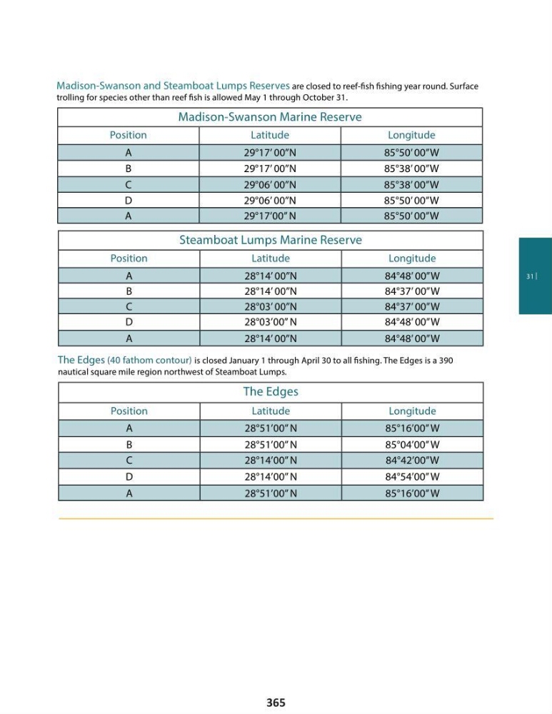
Madison-Swanson and Steamboat Lumps Reserves are closed to reef-fi sh fi shing year round. Surface
trolling for species other than reef fi sh is allowed May 1 through October 31.
The Edges
Position
Latitude
Longitude
A
28°51’00” N
85°16’00” W
B
28°51’00” N
85°04’00” W
C
28°14’00” N
84°42’00”W
D
28°14’00” N
84°54’00” W
A
28°51’00” N
85°16’00” W
The Edges (40 fathom contour) is closed January 1 through April 30 to all fi shing. The Edges is a 390
nautical square mile region northwest of Steamboat Lumps.
365
Madison-Swanson Marine Reserve
Position
Latitude
Longitude
A
29°17’ 00”N
85°50’ 00”W
B
29°17’ 00”N
85°38’ 00”W
C
29°06’ 00”N
85°38’ 00”W
D
29°06’ 00”N
85°50’ 00”W
A
29°17’00” N
85°50’ 00”W
Steamboat Lumps Marine Reserve
Position
Latitude
Longitude
A
28°14’ 00”N
84°48’ 00”W
B
28°14’ 00”N
84°37’ 00”W
C
28°03’ 00”N
84°37’ 00”W
D
28°03’00” N
84°48’ 00”W
A
28°14’ 00”N
84°48’ 00”W
Madison-Swanson and Steamboat Lumps Reserves are closed to reef-fi sh fi shing year round. Surface
trolling for species other than reef fi sh is allowed May 1 through October 31.
The Edges
Position
Latitude
Longitude
A
28°51’00” N
85°16’00” W
B
28°51’00” N
85°04’00” W
C
28°14’00” N
84°42’00”W
D
28°14’00” N
84°54’00” W
A
28°51’00” N
85°16’00” W
The Edges (40 fathom contour) is closed January 1 through April 30 to all fi shing. The Edges is a 390
nautical square mile region northwest of Steamboat Lumps.
365