

22
2017-2018 Texas Commercial Fishing Guide
FRESHWATER/SALTWATER BOUNDARY
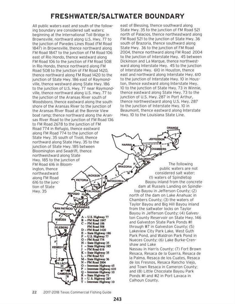
All public waters east and south of the following boundary are considered salt waters:
beginning at the International Toll Bridge in
Brownsville, northward along U.S. Hwy. 77 to
the junction of Paredes Lines Road (FM Road
1847) in Brownsville, thence northward along
FM Road 1847 to the junction of FM Road 106
east of Rio Hondo, thence westward along
FM Road 106 to the junction of FM Road 508
in Rio Hondo, thence northward along FM
Road 508 to the junction of FM Road 1420,
thence northward along FM Road 1420 to the
junction of State Hwy. 186 east of Raymondville, thence westward along State Hwy. 186
to the junction of U.S. Hwy. 77 near Raymondville, thence northward along U.S. Hwy. 77 to
the junction of the Aransas River south of
Woodsboro, thence eastward along the south
shore of the Aransas River to the junction of
the Aransas River Road at the Bonnie View
boat ramp; thence northward along the Aransas River Road to the junction of FM Road 136
to FM Road 2678 to the junction of FM
Road 774 in Refugio, thence eastward
along FM Road 774 to the junction of
State Hwy. 35 south of Tivoli, thence
northward along State Hwy. 35 to the
junction of State Hwy. 185 between
Bloomington and Seadrift, thence
northwestward along State
Hwy. 185 to the junction of
FM Road 616 in Bloomington, thence
northeastward
along FM Road
616 to the junction of State
Hwy. 35
east of Blessing, thence southward along
State Hwy. 35 to the junction of FM Road 521
north of Palacios, thence northeastward along
FM Road 521 to the junction of State Hwy. 36
south of Brazoria, thence southward along
State Hwy. 36 to the junction of FM Road
2004, thence northward along FM Road 2004
to the junction of Interstate Hwy. 45 between
Dickinson and La Marque, thence northwestward along Interstate Hwy. 45 to the junction
of Interstate Hwy. 610 in Houston, thence
east and northward along Interstate Hwy. 610
to the junction of Interstate Hwy. 10 in Houston, thence eastward along Interstate Hwy.
10 to the junction of State Hwy. 73 in Winnie,
thence eastward along State Hwy. 73 to the
junction of U.S. Hwy. 287 in Port Arthur,
thence northwestward along U.S. Hwy. 287
to the junction of Interstate Hwy. 10 in
Beaumont, thence eastward along Interstate
Hwy. 10 to the Louisiana State Line.
The following
public waters are not
considered salt water:
(1) waters of Spindletop
Bayou inland from the concrete
dam at Russels Landing on Spindletop Bayou in Jefferson County; (2)
north of the dam on Lake Anahuac in
Chambers County; (3) the waters of
Taylor Bayou and Big Hill Bayou inland
from the saltwater locks on Taylor
Bayou in Jefferson County; (4) Galveston County Reservoir on State Hwy. 146
and Galveston State Park Ponds #1
through #7 in Galveston County; (5)
Lakeview City Park Lake, West Guth
Park Pond, and Waldron Park Pond in
Nueces County; (6) Lake Burke-Crenshaw and Lake
Nassau in Harris County; (7) Fort Brown
Resaca, Resaca de la Guerra, Resaca de
la Palma, Resaca de los Cuates, Resaca
de los Fresnos, Resaca Rancho Viejo,
and Town Resaca in Cameron County;
and (8) Little Chocolate Bayou Park
Ponds #1 and #2 in Port Lavaca in
Calhoun County.
243
2017-2018 Texas Commercial Fishing Guide
FRESHWATER/SALTWATER BOUNDARY
All public waters east and south of the following boundary are considered salt waters:
beginning at the International Toll Bridge in
Brownsville, northward along U.S. Hwy. 77 to
the junction of Paredes Lines Road (FM Road
1847) in Brownsville, thence northward along
FM Road 1847 to the junction of FM Road 106
east of Rio Hondo, thence westward along
FM Road 106 to the junction of FM Road 508
in Rio Hondo, thence northward along FM
Road 508 to the junction of FM Road 1420,
thence northward along FM Road 1420 to the
junction of State Hwy. 186 east of Raymondville, thence westward along State Hwy. 186
to the junction of U.S. Hwy. 77 near Raymondville, thence northward along U.S. Hwy. 77 to
the junction of the Aransas River south of
Woodsboro, thence eastward along the south
shore of the Aransas River to the junction of
the Aransas River Road at the Bonnie View
boat ramp; thence northward along the Aransas River Road to the junction of FM Road 136
to FM Road 2678 to the junction of FM
Road 774 in Refugio, thence eastward
along FM Road 774 to the junction of
State Hwy. 35 south of Tivoli, thence
northward along State Hwy. 35 to the
junction of State Hwy. 185 between
Bloomington and Seadrift, thence
northwestward along State
Hwy. 185 to the junction of
FM Road 616 in Bloomington, thence
northeastward
along FM Road
616 to the junction of State
Hwy. 35
east of Blessing, thence southward along
State Hwy. 35 to the junction of FM Road 521
north of Palacios, thence northeastward along
FM Road 521 to the junction of State Hwy. 36
south of Brazoria, thence southward along
State Hwy. 36 to the junction of FM Road
2004, thence northward along FM Road 2004
to the junction of Interstate Hwy. 45 between
Dickinson and La Marque, thence northwestward along Interstate Hwy. 45 to the junction
of Interstate Hwy. 610 in Houston, thence
east and northward along Interstate Hwy. 610
to the junction of Interstate Hwy. 10 in Houston, thence eastward along Interstate Hwy.
10 to the junction of State Hwy. 73 in Winnie,
thence eastward along State Hwy. 73 to the
junction of U.S. Hwy. 287 in Port Arthur,
thence northwestward along U.S. Hwy. 287
to the junction of Interstate Hwy. 10 in
Beaumont, thence eastward along Interstate
Hwy. 10 to the Louisiana State Line.
The following
public waters are not
considered salt water:
(1) waters of Spindletop
Bayou inland from the concrete
dam at Russels Landing on Spindletop Bayou in Jefferson County; (2)
north of the dam on Lake Anahuac in
Chambers County; (3) the waters of
Taylor Bayou and Big Hill Bayou inland
from the saltwater locks on Taylor
Bayou in Jefferson County; (4) Galveston County Reservoir on State Hwy. 146
and Galveston State Park Ponds #1
through #7 in Galveston County; (5)
Lakeview City Park Lake, West Guth
Park Pond, and Waldron Park Pond in
Nueces County; (6) Lake Burke-Crenshaw and Lake
Nassau in Harris County; (7) Fort Brown
Resaca, Resaca de la Guerra, Resaca de
la Palma, Resaca de los Cuates, Resaca
de los Fresnos, Resaca Rancho Viejo,
and Town Resaca in Cameron County;
and (8) Little Chocolate Bayou Park
Ponds #1 and #2 in Port Lavaca in
Calhoun County.
243